Mount Morrison (Viktorialand)
| Mount Morrison | ||
|---|---|---|
| Höhe | 1895 m | |
| Lage | Viktorialand, Ostantarktika | |
| Gebirge | Prince Albert Mountains, Transantarktisches Gebirge | |
| Koordinaten | 76° 54′ 0″ S, 161° 32′ 0″ O | |
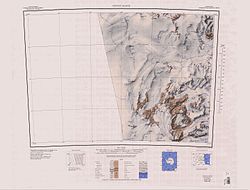
 Kartenblatt Convoy Range von 1988, Mount Morrison und Mount Brøgger in der südöstlichen Ecke | ||
Mount Morrison ist ein 1895 m hoher Berg im ostantarktischen Viktorialand. Er ragt zwischen dem Midship-Gletscher und dem Kopfende des Cleveland-Gletschers in den Prince Albert Mountains auf.
Entdeckt wurde er von Teilnehmern der britischen Discovery-Expedition (1901–1904), die ihn nach John Donald Morrison (* 1873) benannten, Offizier des Rettungsschiffs Morning bei dieser Forschungsreise.
Weblinks
- Mount Morrison. In: Geographic Names Information System. United States Geological Survey, United States Department of the Interior, archiviert vom (englisch).
- Mount Morrison auf geographic.org (englisch)
Auf dieser Seite verwendete Medien
Autor/Urheber: Alexrk2, Lizenz: CC BY-SA 3.0
Physische Positionskarte Antarktis, Mittabstandstreue Azimutalprojektion
1:250,000-scale topographic reconnaissance map of the Convoy Range area from 156°-162'E to 76°-77°S in Antarctica. Mapped, edited and published by the U.S. Geological Survey in cooperation with the National Science Foundation.


