Mount Liebig
| Mount Liebig | ||
|---|---|---|
 Mt. Liebig, Juli 2012 | ||
| Höhe | 1524 m | |
| Lage | Northern Territory, Australien | |
| Gebirge | MacDonnell Ranges | |
| Koordinaten | 23° 17′ 19″ S, 131° 21′ 52″ O | |
Der Mount Liebig ist ein Berg im Northern Territory in Australien. Er ist 1.524 Meter hoch und ist damit einer der höchsten Gipfel der MacDonnell Ranges. Der Mount Liebig wurde von dem Forscher Ernest Giles nach dem deutschen Chemiker Justus von Liebig benannt[1].
Weblinks
- Mt. Liebig bei www.peakbagger.com; 3. September 2009
- Mount Liebig and Surrounds (pdf) (Memento vom 4. Juni 2011 im Internet Archive) – amtliche Broschüre zu Mount Liebig und Umgebung (abgerufen 4. September 2009)
Einzelnachweise
- ↑ Ernest Favenc: The History of Australian Exploration from 1788 to 1888. Echo Library 2006, ISBN 978-1-4068-2067-6, S. 184
Auf dieser Seite verwendete Medien
Autor/Urheber: Tentotwo, Lizenz: CC BY-SA 3.0
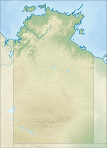
Relief location map of the Northern Territory, Australia Equidistant cylindrical projection, latitude of true scale 17.75° S (equivalent to equirectangular projection with N/S stretching 105 %). Geographic limits of the map:
- N: 10.6° S
- S: 26.5° S
- W: 127.5° E
- E: 139.5° E
Autor/Urheber: Summerdrought, Lizenz: CC BY-SA 4.0
Mount Liebig in the Northern Territory, Australia, looking east along the Gary Junction Road


