Mount Guyot (North Carolina)
| Mount Guyot | ||
|---|---|---|
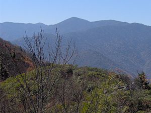
(c) I, Brian Stansberry, CC BY 2.5 Mount Guyot (Mitte) vom Mount Cammerer aus | ||
| Höhe | 2018 m | |
| Lage | North Carolina, Vereinigte Staaten | |
| Gebirge | Appalachen | |
| Koordinaten | 35° 42′ 0″ N, 83° 15′ 0″ W | |
Der Mount Guyot ist ein 2018 m hoher Berg in den Appalachen und Teil des Great-Smoky-Mountains-Nationalparks im US-Bundesstaat North Carolina an der Grenze zu Tennessee. Er befindet sich auf halben Weg zwischen Asheville und Knoxville. Der Berg wurde nach dem Geologen und Geographen Arnold Henri Guyot benannt, der im 19. Jahrhundert die erste exakte Karte dieses Teils der Appalachen verfertigte.
Auf dieser Seite verwendete Medien
(c) I, Brian Stansberry, CC BY 2.5
The Guyot massif in the Great Smoky Mountains, looking west from Mt. Cammerer. Mt. Guyot is the high peak at the center, flanked by Old Black on the right and Mount Chapman on the left. The elevation of Mt. Cammerer is 4,928 feet/1,502 meters.
Autor/Urheber: Alexrk2, Lizenz: CC BY 3.0
Physische Positionskarte von North Carolina, USA


