Mota Lava
| Mota Lava | ||
|---|---|---|
 | ||
| Gewässer | Korallenmeer | |
| Inselgruppe | Banks-Inseln | |
| Geographische Lage | 13° 41′ 0″ S, 167° 40′ 0″ O | |
| Fläche | 24 km² | |
| Höchste Erhebung | 411 m | |
| Einwohner | 1451 (2009) 60 Einw./km² | |
| Hauptort | Lahlap | |
 | ||
Mota Lava, auch Motalava, ist eine Insel der Banks-Inseln im Norden des pazifischen Inselstaates Vanuatu.
Sie liegt nordöstlich von Vanua Lava und zählt wie diese zur vanuatuischen Provinz Torba. Mota Lava ist bewohnt und verfügt sogar über ein kleines Flugfeld. Die 24 km²[1] große Insel besteht aus mindestens fünf basaltischen Schichtvulkanen sowie zwei Pyroklastischen Kegeln und erreicht eine Höhe von 411 m über dem Meer. Knapp 300 Meter vor der Südwestküste liegt die ebenfalls bewohnte Nebeninsel Ra. Ra und Mota Lava werden von einem gemeinsamen Korallenriff umgeben.
Weblinks
- Mota Lava im Global Volcanism Program der Smithsonian Institution (englisch)
Einzelnachweise
- ↑ UNEP Islands Directory (englisch)
Auf dieser Seite verwendete Medien
Autor/Urheber: Eric Gaba (Sting - fr:Sting), Lizenz: CC BY-SA 3.0
Blank physical map of Vanuatu in Oceania, for geo-location purpose.
Autor/Urheber:
- Banks_Islands-fr.svg: Mutichou
- derivative work: Womtelo (talk)
- Original source file for placenames: Womtelo
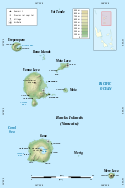
Map of Banks Islands, Vanuatu in English. Note: the shaded relief is a raster picture embedded in the SVG file.
Astronaut photo of Mota Lava island, in the Banks Islands, Vanuatu. North at top. Cropped from Image:ESC large ISS006 ISS006-E-26739.JPG, rotated, colour rebalanced. (If these manipulations give me any copyright in the transformed image, I release it to the public domain.)
Original image metadata follows:
- Mission: ISS006 Roll: E Frame: 26739 Mission ID on the Film or image: ISS006
- Country or Geographic Name: VANUATU
- Features: BANKS ISLANDS, MOTA, SADDLE I.
- Center Point Latitude: -14.0 Center Point Longitude: 167.5 (Negative numbers indicate south for latitude and west for longitude)
- Date: 20030210 (YYYYMMDD)GMT Time: 222701 (HHMMSS)
- Nadir Point Latitude: -14.1, Longitude: 165.5 (Negative numbers indicate south for latitude and west for longitude)
- Nadir to Photo Center Direction: East
- Sun Azimuth: 96 (Clockwise angle in degrees from north to the sun measured at the nadir point)
- Spacecraft Altitude: 211 nautical miles (391 km)
- Sun Elevation Angle: 50 (Angle in degrees between the horizon and the sun, measured at the nadir point)
- Orbit Number: 130


