Massachusetts Route 203
 | |
|---|---|
| Karte | |
 | |
| Basisdaten | |
| Gesamtlänge: | 5,18 mi (8,3 km)[1] |
| Eröffnung: | Anfang der 1970er Jahre |
| Anfangspunkt: | Jamaica Pond in Jamaica Plain |
| Endpunkt: | |
| County: | Suffolk County |
| Wichtige Stadt: | Boston |
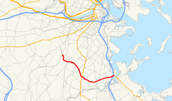
Die Massachusetts Route 203 ist eine 5,18 mi (8,3 km) lange State Route in Boston im Bundesstaat Massachusetts der Vereinigten Staaten mit Verlauf von Westen nach Osten. Sie beginnt im Stadtteil Jamaica Plain am Jamaica Pond und verläuft dann südost- bzw. ostwärts über den Arborway sowie die Parkways Morton Street und Gallivan Boulevard bis zu ihrem Ende am Neponset Circle im Stadtteil Dorchester, wo sie Anschlussverbindungen an den U.S. Highway 1, die I-93, Massachusetts Route 3 und die Massachusetts Route 3A bietet.
Instandhaltung
Bevor das Massachusetts Department of Transportation (MassDOT) im Jahr 2009 gegründet wurde, befand sich die Massachusetts Route 203 vollständig im Eigentum des Department of Conservation and Recreation (DCR). Am 1. November 2009 wurden dann der Msgr. William Casey Highway Overpass in Jamaica Plain, die Morton Street in Mattapan und der Gallivan Boulevard in Dorchester an das MassDOT übertragen, während der Arborway unter der Kontrolle des DCR blieb.[2][3]
Geschichte
Die Massachusetts Route 203 wurde in den frühen 1970er Jahren als Teil einer umfangreichen Neubenennung bzw. Neunummerierung von Straßen im Umfeld der Stadt Boston gebildet. Der größte Teil der Strecke war zuvor Teil der Massachusetts Route 3, die südlich mit dem U.S. Highway 1 entlang des Jamaicaway verlief und von diesem in Richtung Osten entlang der heutigen Streckenführung abzweigte. An der Granite Avenue wandte sich die Route 3 nach Süden, um in Milton auf den Southeast Expressway zu treffen, während die nicht abzweigende Strecke als Massachusetts Route 3A weitergeführt wurde.
Im Zuge der neuen Nummerierung wurden die Route 3 auf dem Southeast Expressway bis in das Stadtzentrum geführt, die Route 3A bis an ihr heutiges Ende gekürzt und die ehemaligen Streckenführungen der Route 3 und 3A neu zur Route 203 zusammengesetzt. Zugleich wurde das Ende des U.S. Highway 1 verlegt, so dass es heute nicht mehr an eine nummerierte State Route anschließt.
Siehe auch
Einzelnachweise
- ↑ Road Inventory. (Nicht mehr online verfügbar.) Massachusetts Department of Transportation, archiviert vom Original am 20. Juni 2012; abgerufen am 15. Oktober 2012 (englisch). Info: Der Archivlink wurde automatisch eingesetzt und noch nicht geprüft. Bitte prüfe Original- und Archivlink gemäß Anleitung und entferne dann diesen Hinweis.
- ↑ Session Laws. Chapter 25. Massachusetts General Court, 2009, abgerufen am 15. Oktober 2012 (englisch).
- ↑ Christina Pazzanese: A big concern on two major parkways. In: The Boston Globe. 12. September 2009, abgerufen am 15. Oktober 2012 (englisch).
Auf dieser Seite verwendete Medien
600 mm by 600 mm (24 in by 24 in) Massachusetts Route shield, made to the specifications of the 1996 edition of Construction and Traffic Standard Details (sign M1-5). Uses the Roadgeek 2005 fonts. (United States law does not permit the copyrighting of typeface designs, and the fonts are meant to be copies of a U.S. Government-produced work anyway.) The outside border has a width of 1 (1 mm) and a color of black so it shows up; in reality, signs have no outside border. The specs actually do not show the curve on the outside border, instead making it a perfect square, but all signs I have seen round the corners.
Official highway sign placed along many state highways indicating a corporate boundary. This sign indicates entering the city of Boston.
Autor/Urheber: Jameslwoodward, Lizenz: CC BY-SA 3.0
Morton Street, Boston, MA
750 mm by 600 mm (30 in by 24 in) Massachusetts Route shield, made to the specifications of the 1996 edition of Construction and Traffic Standard Details (sign M1-5). Uses the Roadgeek 2005 fonts. (United States law does not permit the copyrighting of typeface designs, and the fonts are meant to be copies of a U.S. Government-produced work anyway.) The outside border has a width of 1 (1 mm) and a color of black so it shows up; in reality, signs have no outside border. The specs actually do not show the curve on the outside border, instead making it a perfect rectangle, but all signs I have seen round the corners. Note: The specs specify Series D font for the numbers. However, that font does not fit when none of the characters is a one, and so those signs actually use Series C. This image is true to real signs, not the specs.
600 mm by 600 mm (24 in by 24 in) Massachusetts Route shield, made to the specifications of the 1996 edition of Construction and Traffic Standard Details (sign M1-5). Uses the Roadgeek 2005 fonts. (United States law does not permit the copyrighting of typeface designs, and the fonts are meant to be copies of a U.S. Government-produced work anyway.) The outside border has a width of 1 (1 mm) and a color of black so it shows up; in reality, signs have no outside border. The specs actually do not show the curve on the outside border, instead making it a perfect square, but all signs I have seen round the corners.
600 mm × 600 mm (24 in × 24 in) U.S. Highway shield, made to the specifications of the 2004 edition of Standard Highway Signs. (Note that there is a missing "J" label on the left side of the diagram.) Uses the Roadgeek 2005 fonts. (United States law does not permit the copyrighting of typeface designs, and the fonts are meant to be copies of a U.S. Government-produced work anyway.)
Map of Massachusetts Route 203


