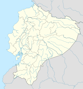
Montecristi
| Montecristi | |||
|---|---|---|---|
| |||
| Koordinaten | 1° 3′ 1″ S, 80° 39′ 37″ W | ||
| Basisdaten | |||
| Staat | Ecuador | ||
| Provinz | Manabí | ||
| Kanton | Montecristi | ||
| Stadtgründung | 1741 | ||
| Einwohner | 46.311 (2010) | ||
| Detaildaten | |||
| Höhe | 140 m | ||
| Stadtgliederung | 6 Parroquias urbanas | ||
| Zeitzone | UTC−5 | ||
| Website | |||
Montecristi ist eine Stadt im Westen Ecuadors nahe der Stadt Manta. Sie liegt in der Provinz Manabí und ist Verwaltungssitz des gleichnamigen Kantons. Die Stadt hatte 2010 46.000 Einwohner.[1]
Geschichte
Montecristi war eine der ersten Städte, die sich der Revolution vom 9. Oktober 1820 anschloss und am 23. Oktober 1820 ihre Unabhängigkeit ausrief.
Kultur und Sehenswürdigkeiten
Montecristi ist vor allem für die Produktion von Panamahüten bekannt. Die qualitativ hochwertigsten Hüte nennt man daher auch montecristi superfino. Hier fand die Verfassunggebende Versammlung Ecuadors 2007/08 statt im Konferenzzentrum Ciudad Alfaro. Dieses wurde zu Ehren eines berühmten Sohns der Stadt benannt, Eloy Alfaro (1842–1912), Präsident Ecuadors von 1895 bis 1901 und von 1906 bis 1911. Größte Kirche im Ort ist die Basílica Nuestra Señora de Monserrate.
Galerie
Municipio
Das Municipio von Montecristi hat eine Fläche von 639,9 km². Beim Zensus 2010 betrug die Einwohnerzahl 67.842. Das Municipio ist in folgende Parroquias urbanas gegliedert:
- Montecristi
- Aníbal San Andrés (⊙ 1999 gegründet)
- Colorado (⊙ 2007 gegründet)
- General Alfaro (⊙ 2007 gegründet; Namensgeber war Eloy Alfaro)
- Leonidas Proaño (⊙ 2007 gegründet; Namensgeber war Leonidas Proaño)
- Isabel Muentes (⊙ 2019 gegründet; Namensgeberin war María Isabel Muentes (* 1838), eine Heldin der Revolución Alfarista, die am 5. Juni 1864 einen Aufstand anführte; umfasst folgende Sectores: Tierra Santa, Santa Isabela, San Rafael, Los Artesanos, Ciudad Jardín, Cielito Lindo, Belo Horizonte, 4 de Agosto und Cuna de Alfaro)
![]() Karte mit allen Koordinaten: OSM | WikiMap
Karte mit allen Koordinaten: OSM | WikiMap
Weblinks
Einzelnachweise
- ↑ Ecuador: Provinces, Major Cities & Towns - Population Statistics in Maps and Charts. Abgerufen am 24. November 2017 (englisch).
Auf dieser Seite verwendete Medien
Autor/Urheber: Agencia de Noticias ANDES, Lizenz: CC BY-SA 2.0
Montecristi, Manabí, 09 de may (Andes).-Al pie del cerro de Montecristi se levanta el Centro Cívico Ciudad Alfaro, la obra que fue presentada en el 2007, es un centro cívico lleno de arquitectura combinada con rasgos de la historia de Manabí y el país.
Foto:César Muñoz/AndesAutor/Urheber: Arabsalam, Lizenz: CC BY-SA 4.0
Basílica Nuestra Señora de Monserrate
Autor/Urheber: Agencia de Noticias ANDES, Lizenz: CC BY-SA 2.0
Montecristi, Manabí, 09 de may (Andes).-Al pie del cerro de Montecristi se levanta el Centro Cívico Ciudad Alfaro, la obra que fue presentada en el 2007, es un centro cívico lleno de arquitectura combinada con rasgos de la historia de Manabí y el país. Dentro se levanta un monumento de Eloy Alfaro de seis metros de altura
Foto:César Muñoz/AndesAutor/Urheber: Sylvain2803, Lizenz: CC BY-SA 3.0
Panorama of Montecristi, Ecuador, from Ciudad Alfaro


