Montagny-lès-Seurre
| Montagny-lès-Seurre | ||
|---|---|---|
| ||
| Staat | ||
| Region | Bourgogne-Franche-Comté | |
| Département (Nr.) | Côte-d’Or (21) | |
| Arrondissement | Beaune | |
| Kanton | Brazey-en-Plaine | |
| Gemeindeverband | Communauté de communes Rives de Saône | |
| Koordinaten | 47° 1′ N, 5° 15′ O | |
| Höhe | 181–193 m | |
| Fläche | 7,16 km² | |
| Einwohner | 115 (1. Januar 2022) | |
| Bevölkerungsdichte | 16 Einw./km² | |
| Postleitzahl | 21250 | |
| INSEE-Code | 21424 | |
 Montagny-lès-Seurre | ||
Montagny-lès-Seurre ist eine französische Gemeinde mit 115 Einwohnern (Stand 1. Januar 2022) im Département Côte-d’Or in der Region Bourgogne-Franche-Comté. Sie gehört zum Arrondissement Beaune und zum Kanton Brazey-en-Plaine.
Nachbargemeinden sind Franxault im Norden, Saint-Aubin im Nordosten, Tichey im Osten, Bousselange im Südosten, Grosbois-lès-Tichey im Süden und Pagny-le-Château im Westen.
Bevölkerungsentwicklung
| Jahr | 1962 | 1968 | 1975 | 1982 | 1990 | 1999 | 2008 | 2015 | |
|---|---|---|---|---|---|---|---|---|---|
| Einwohner | 109 | 111 | 112 | 107 | 119 | 112 | 107 | 104 | |
| Quellen: Cassini und INSEE | |||||||||
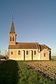 Kirche Saint-Vincent
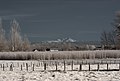 Blick zum Mont Blanc von Montagny-lès-Seurre aus
Siehe auch
- Liste der Monuments historiques in Montagny-lès-Seurre
Weblinks
Commons: Montagny-lès-Seurre – Sammlung von Bildern, Videos und Audiodateien
Auf dieser Seite verwendete Medien

France adm-2 location map.svg
(c) Karte: NordNordWest, Lizenz: Creative Commons by-sa-3.0 de
Positionskarte von Frankreich mit Regionen und Départements
(c) Karte: NordNordWest, Lizenz: Creative Commons by-sa-3.0 de
Positionskarte von Frankreich mit Regionen und Départements

Montagny les Seurre 0038.JPG
Autor/Urheber: Grondin, Lizenz: CC BY-SA 3.0
Village de Tichey photographié depuis l'ancienne école de Montagny-lès-Seurre (Côte d'Or, Bourgogne, France)
Autor/Urheber: Grondin, Lizenz: CC BY-SA 3.0
Village de Tichey photographié depuis l'ancienne école de Montagny-lès-Seurre (Côte d'Or, Bourgogne, France)

Montagny-lès-Seurre 2014 02 17 03 IR M8.jpg
Autor/Urheber: Bertrand GRONDIN → (Talk),
Lizenz: CC BY-SA 3.0
→ (Talk),
Lizenz: CC BY-SA 3.0
Diese Grafik wurde mit Qtpfsgui erstellt.
Autor/Urheber: Bertrand GRONDIN
Diese Grafik wurde mit Qtpfsgui erstellt.

Montagny-lès-Seurre 2014 02 17 08 M8.jpg
Autor/Urheber: Bertrand GRONDIN → (Talk),
Lizenz: CC BY-SA 3.0
Diese Grafik wurde mit Qtpfsgui erstellt.
Autor/Urheber: Bertrand GRONDIN
Diese Grafik wurde mit Qtpfsgui erstellt.