Mobile County
 | |
| Verwaltung | |
|---|---|
| US-Bundesstaat: | Alabama |
| Verwaltungssitz: | Mobile |
| Adresse des Verwaltungssitzes: | County Courthouse 205 Government Street Mobile, AL 36602-2613 |
| Gründung: | 18. Dezember 1812 |
| Gebildet aus: | Original-County |
| Vorwahl: | 001 251 |
| Demographie | |
| Einwohner: | 414.809 (Stand: 2020) |
| Bevölkerungsdichte: | 129,87 Einwohner/km² |
| Geographie | |
| Fläche gesamt: | 4258 km² |
| Wasserfläche: | 1064 km² |
| Karte | |
 | |
| Website: www.mobilecountyal.gov | |
Das Mobile County[1][2] ist ein County im US-Bundesstaat Alabama. Bei der Volkszählung im Jahr 2020 hatte das County 414.809 Einwohner und eine Bevölkerungsdichte von 129,3 Einwohnern pro Quadratkilometer. Der Verwaltungssitz (County Seat) ist Mobile.[3]
Geographie
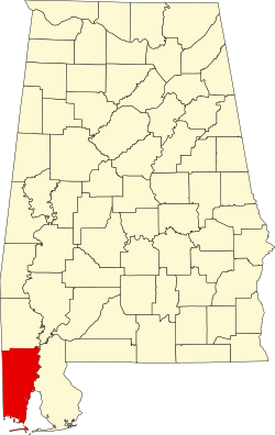
Das County liegt im äußersten Südwesten von Alabama an der Mündung des Mobile River in die Mobile Bay, einen Teil des Golf von Mexiko, der das County im Süden begrenzt. Es hat eine Fläche von 4.258 Quadratkilometern, wovon 1.064 Quadratkilometer Wasserflächen sind. An das Mobile County grenzen folgende Countys:
| Greene County (Mississippi) | Washington County | |
| George County (Mississippi) |  | Baldwin County |
| Jackson County (Mississippi) |
Botanik im County

In Theodore befindet sich das historische Bellingrath Gardens and Home, ein 26 Hektar großer botanischer Garten. Der Garten liegt am Fowl River und wurde am 19. Oktober 1982 als Historic District unter der Nummer 82001609 in das National Register of Historic Places eingetragen.[4]
Ein anderer botanischer Garten des Countys befindet sich in Mobile, dem Verwaltungssitz. Es sind dies die Mobile Botanical Gardens, mit einer Fläche von 404.656 m².
Geschichte


Das Gebiet des heutigen Mobile County gehörte von 1702 bis 1763 zu Frankreich, danach bis 1780 zu Großbritannien und von 1780 bis 1813 zu Spanien.
Das Mobile County wurde am 18. Dezember 1812 per Proklamation durch David Holmes, den damaligen Gouverneur des Mississippi-Territoriums, gebildet. Die Benennung erfolgte nach der gleichnamigen Bucht, Fluss und Stadt. Diese wiederum gründen in dem französischen Fort Louis de la Mobile, das hier 1702 entstand und seinen Namen von den dort ursprünglich lebenden Mobile ableitete.[5]
Das Gerichtsgebäude wurde 1832, 1840 und 1872 jeweils durch ein Feuer zerstört.

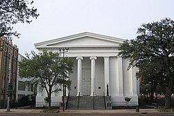
137 Bauwerke und Stätten im County sind im National Register of Historic Places (NRHP) eingetragen (Stand 5. April 2020), darunter haben vier den Status eines National Historic Landmarks: das Schlachtschiff USS ALABAMA, das U-Boot USS DRUM, die Mobile City Hall und die Government Street Presbyterian Church.[6]
Demografische Daten
| Bevölkerungswachstum | |||
|---|---|---|---|
| Census | Einwohner | ± rel. | |
| 1820 | 2.672 | — | |
| 1830 | 6.267 | 134,5 % | |
| 1840 | 18.741 | 199 % | |
| 1850 | 27.600 | 47,3 % | |
| 1860 | 41.131 | 49 % | |
| 1870 | 49.311 | 19,9 % | |
| 1880 | 48.653 | −1,3 % | |
| 1890 | 51.587 | 6 % | |
| 1900 | 62.740 | 21,6 % | |
| 1910 | 80.854 | 28,9 % | |
| 1920 | 100.117 | 23,8 % | |
| 1930 | 118.363 | 18,2 % | |
| 1940 | 141.974 | 19,9 % | |
| 1950 | 231.105 | 62,8 % | |
| 1960 | 314.301 | 36 % | |
| 1970 | 317.308 | 1 % | |
| 1980 | 364.980 | 15 % | |
| 1990 | 378.643 | 3,7 % | |
| 2000 | 399.843 | 5,6 % | |
| 2010 | 412.992 | 3,3 % | |
| 2020 | 414.809 | 0,4 % | |
| Vor 1900[7] 1900–1990[8] 2000[9] 2010[10] 2020[11] | |||
Nach der Volkszählung im Jahr 2010 lebten im Mobile County 412.992 Menschen in 155.657 Haushalten. Die Bevölkerungsdichte betrug 129,3 Einwohner pro Quadratkilometer.
Ethnisch betrachtet setzte sich die Bevölkerung zusammen aus 60,2 Prozent Weißen, 34,6 Prozent Afroamerikanern, 0,9 Prozent amerikanischen Ureinwohnern, 1,8 Prozent Asiaten sowie aus anderen ethnischen Gruppen; 1,5 Prozent stammten von zwei oder mehr Ethnien ab. Unabhängig von der ethnischen Zugehörigkeit waren 2,4 Prozent der Bevölkerung spanischer oder lateinamerikanischer Abstammung.
In den 155.657 Haushalten lebten statistisch je 2,55 Personen.
25,9 Prozent der Bevölkerung waren unter 18 Jahre alt, 61,6 Prozent waren zwischen 18 und 64 und 12,5 Prozent waren 65 Jahre oder älter. 52,0 Prozent der Bevölkerung war weiblich.
Das jährliche Durchschnittseinkommen eines Haushalts lag bei 39.828 USD. Das Prokopfeinkommen betrug 21.274 USD. 18,7 Prozent der Einwohner lebten unterhalb der Armutsgrenze.[12]
Orte im Mobile County
Census-designated places (CDP)
|
andere Unincorporated Communitys
|
|
|
- weitere Orte
- Akka
- Allenville
- Bayleys Corner
- Chastang
- Cottage Hill
- Country Club Estates
- Country Club Village
- Cox Beach
- Crichton
- Dawes
- Delchamps
- Dixon Corner
- Farnell
- Faustinas
- Forest Hill
- Forest Park
- Fort Gaines
- Fort Stoddard
- Fowl River
- Georgetown
- Hatters
- Jackson Heights
- Laurendine
- Lloyds
- Mackies
- Magazine
- Mann
- Mertz
- Millertown
- Moffet
- Movico
- Navco
- Neely
- Nenemoosha
- Neshota
- North Mobile
- Oak Grove
- Orchard
- Pennsylvania
- Pine Grove
- Pineola
- Plateau
- Salco
- San Souci Beach
- Seven Hills
- Sibert
- Sidney
- Smithport
- Smithtown
- South Orchard
- Spring Hill
- Summerville
- Sunny Cove
- Tacon
- Tanner Williams
- Toulminville
- Union Church
- Warley
- Wheelerville
Literatur
- Thomas McAdory Owen: History of Alabama and Dictionary of Alabama Biography. S. J. Clarke Publishing Co., Chicago IL 1921.
- Virginia O. Foscue: Place Names in Alabama. University of Alabama Press, Tuscaloosa u. a. 1989, ISBN 0-8173-0410-X.
Weblinks
- Offizielle Website
- U.S. Census Buero, State & County QuickFacts - Mobile County
- Yahoo Bildersuche - Mobile County
- www.city-data.com - Mobile County
- Herbert J. “Jim” Lewis: Mobile County. In: Encyclopedia of Alabama.
Einzelnachweise
- ↑ Mobile County. In: Geographic Names Information System. United States Geological Survey, United States Department of the Interior, abgerufen am 5. September 2024 (englisch).
- ↑ Mobile County bei alabama.gov Abgerufen am 12. Februar 2011
- ↑ National Association of Counties Abgerufen am 28. November 2011
- ↑ Bellingrath Gardens and Home im National Register Information System. National Park Service, abgerufen am 19. April 2020.
- ↑ Charles Curry Aiken, Joseph Nathan Kane: The American Counties: Origins of County Names, Dates of Creation, Area, and Population Data, 1950–2010. 6. Auflage. Scarecrow Press, Lanham 2013, ISBN 978-0-8108-8762-6, S. 209.
- ↑ Suchmaske Datenbank im National Register Information System. National Park Service, abgerufen am 5. April 2020.
Weekly List im National Register Information System. National Park Service, abgerufen am 5. April 2020.
Listing of National Historic Landmarks by State: Alabama. National Park Service, abgerufen am 5. April 2020. - ↑ U.S. Census Bureau - Census of Population and Housing Abgerufen am 15. März 2011.
- ↑ Auszug aus Census.gov Abgerufen am 28. Februar 2011.
- ↑ Auszug aus factfinder.census.gov (Seite nicht mehr abrufbar, festgestellt im Dezember 2022. Suche in Webarchiven) Info: Der Link wurde automatisch als defekt markiert. Bitte prüfe den Link gemäß Anleitung und entferne dann diesen Hinweis. Abgerufen am 28. Februar 2011
- ↑ United States Census 2010 Abgerufen am 28. November 2011.
- ↑ Eintrag bei Census.gov. Abgerufen am 29. Januar 2022.
- ↑ U.S. Census Buero, State & County QuickFacts - Mobile County ( des vom 15. Juli 2011 auf WebCite) Info: Der Archivlink wurde automatisch eingesetzt und noch nicht geprüft. Bitte prüfe Original- und Archivlink gemäß Anleitung und entferne dann diesen Hinweis. Abgerufen am 28. November 2011
Koordinaten: 30° 47′ N, 88° 13′ W
Auf dieser Seite verwendete Medien
Bellingrath Gardens and Home, the creation of Mr. and Mrs. Walter Bellingrath in Theodore, Alabama
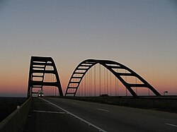
General Walter K. Wilson Bridge carrying Interstate 65 over the Mobile River north of Mobile, Alabama.
Original description: County court house and jail, Mobile, Ala. Additional description: Built by Rudolph Benz in 1889, hurricanes in 1906 and 1916 would remove its clock and much of its statuary. It is already missing at least one standing "Goddess of Liberty" over the main Government Street portico in this image, although one is visible on the Royal Street side gable. It was demolished in the 1950s and a new courthouse was built on the site. That new courthouse has also been demolished, as of 2007.
Mobile Government Plaza in Mobile, Alabama. Houses city and county government. View of Church Street facade from the southeast.
This is a locator map showing Mobile County in Alabama. For more information, see Commons:United States county locator maps.
Government Street Presbyterian Church in Mobile, Alabama.


