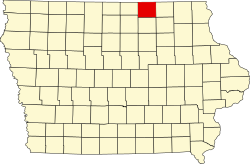
Mitchell County (Iowa)
![Mitchell Das County Courthouse in Osage, gelistet im NRHP Nr. 77000542[1]](http://upload.wikimedia.org/wikipedia/commons/thumb/c/c9/Mitchell_County_Courthouse%2C_Osage.jpg/298px-Mitchell_County_Courthouse%2C_Osage.jpg) Mitchell Das County Courthouse in Osage, gelistet im NRHP Nr. 77000542[1] | |
| Verwaltung | |
|---|---|
| US-Bundesstaat: | Iowa |
| Verwaltungssitz: | Osage |
| Adresse des Verwaltungssitzes: | County Courthouse 508 State Street Osage, IA 50461-1250 |
| Gründung: | 1851 |
| Gebildet aus: | Chickasaw County |
| Vorwahl: | 001 641 |
| Demographie | |
| Einwohner: | 10.565 (Stand: 2020) |
| Bevölkerungsdichte: | 8,7 Einwohner/km2 |
| Geographie | |
| Fläche gesamt: | 1216 km² |
| Wasserfläche: | 1 km² |
| Karte | |
 | |
| Website: www.mitchellcoia.us | |
Das Mitchell County[2] ist ein County im US-Bundesstaat Iowa. Bei der Volkszählung im Jahr 2020 hatte das County 10.565[3] Einwohner und eine Bevölkerungsdichte von 8,7 Einwohnern pro Quadratkilometer. Der Verwaltungssitz (County Seat) ist Osage[4], benannt nach Orrin Sage einem frühen Förderer der Stadt.
Geographie
Das County liegt im Nordosten von Iowa, grenzt im Norden an Minnesota und hat eine Fläche von 1.216 Quadratkilometern, wovon ein Quadratkilometer Wasserfläche ist. Es grenzt an folgende Nachbarcountys:
| Mower County (Minnesota) | ||
| Worth County |  | Howard County |
| Cerro Gordo County | Floyd County | Chickasaw County |
Geschichte

Das Mitchell County wurde 1851 aus ehemaligen Teilen des Chickasaw County gebildet. Benannt wurde es nach John Mitchel (1815–1875), einem irischen Patrioten.
10 Bauwerke des Countys sind im National Register of Historic Places eingetragen.[5]
Demografische Daten
| Bevölkerungswachstum | |||
|---|---|---|---|
| Census | Einwohner | ± rel. | |
| 1860 | 3.409 | — | |
| 1870 | 9.582 | 181,1 % | |
| 1880 | 14.363 | 49,9 % | |
| 1890 | 13.299 | −7,4 % | |
| 1900 | 14.916 | 12,2 % | |
| 1910 | 13.435 | −9,9 % | |
| 1920 | 13.921 | 3,6 % | |
| 1930 | 14.065 | 1 % | |
| 1940 | 14.121 | 0,4 % | |
| 1950 | 13.945 | −1,2 % | |
| 1960 | 14.043 | 0,7 % | |
| 1970 | 13.108 | −6,7 % | |
| 1980 | 12.329 | −5,9 % | |
| 1990 | 10.928 | −11,4 % | |
| 2000 | 10.874 | −0,5 % | |
| 2010 | 10.776 | −0,9 % | |
| 2020 | 10.565 | −2 % | |
| Vor 1900[6] 1900–1990[7] 2000–2010[8] | |||
Nach der Volkszählung im Jahr 2010 lebten im Mitchell County 10.776 Menschen in 4.186 Haushalten. Die Bevölkerungsdichte betrug 8,9 Einwohner pro Quadratkilometer.
Ethnisch betrachtet setzte sich die Bevölkerung zusammen aus 98,6 Prozent Weißen, 0,2 Prozent Afroamerikanern, 0,1 Prozent amerikanischen Ureinwohnern, 0,3 Prozent Asiaten sowie aus anderen ethnischen Gruppen; 0,5 Prozent stammten von zwei oder mehr Ethnien ab. Unabhängig von der ethnischen Zugehörigkeit waren 1,0 Prozent der Bevölkerung spanischer oder lateinamerikanischer Abstammung.
In den 4.186 Haushalten lebten statistisch je 2,51 Personen.
24,7 Prozent der Bevölkerung waren unter 18 Jahre alt, 53,6 Prozent waren zwischen 18 und 64 und 21,7 Prozent waren 65 Jahre oder älter. 50,7 Prozent der Bevölkerung war weiblich.
Das jährliche Durchschnittseinkommen eines Haushalts lag bei 46.684 USD. Das Prokopfeinkommen betrug 22.622 USD. 9,0 Prozent der Einwohner lebten unterhalb der Armutsgrenze.[8]
Orte im Mitchell County
|
|
|
|
1 – teilweise im Howard County
Gliederung
Das Mitchell County ist in 16 Townships eingeteilt[10]:
|
|
|
|
Einzelnachweise
- ↑ Auszug aus dem National Register of Historic Places Abgerufen am 13. März 2011
- ↑ Mitchell County. In: Geographic Names Information System. United States Geological Survey, United States Department of the Interior, abgerufen am 26. Februar 2011 (englisch).
- ↑ US Census Bureau: Search Results Total Population in Mitchell County, Iowa. Abgerufen am 21. Februar 2024 (amerikanisches Englisch).
- ↑ National Association of Counties Abgerufen am 22. Januar 2012
- ↑ Suchmaske Datenbank im National Register Information System. National Park Service, abgerufen am 26. August 2017.
- ↑ U.S. Census Bureau - Census of Population and Housing Abgerufen am 15. März 2011
- ↑ Auszug aus Census.gov Abgerufen am 16. Februar 2011
- ↑ a b U.S. Census Buero, State & County QuickFacts - Mitchell County, IA ( vom 14. Juli 2011 auf WebCite) Abgerufen am 22. Januar 2012
- ↑ Auszug aus dem National Register of Historic Places - Nr. 02001030 Abgerufen am 22. Januar 2012
- ↑ 2010 US Census Iowa Township and Other Subdivision Population. (PDF) Abgerufen am 23. Juli 2019.
Weblinks
Koordinaten: 43° 21′ N, 92° 47′ W
Auf dieser Seite verwendete Medien
This is a locator map showing Mitchell County in Iowa. For more information, see Commons:United States county locator maps.
(c) Billwhittaker in der Wikipedia auf Englisch, CC BY-SA 3.0
Downtown Osage, Iowa
[Added by Nyttend:] picture appears to be taken looking westward along Main Street at the intersection with 8th Street; the buildings shown are part of the Osage Commercial Historic District listed on the National Register of Historic Places
(c) Billwhittaker in der Wikipedia auf Englisch, CC BY-SA 3.0
Downtown Stacyville, Iowa
The Mitchell County Courthouse, located at 500 State St. in Osage, Mitchell County, Iowa, United States. Built in 1858, it was added to the National Register of Historic Places on 29 August 1977.
Image source John Mitchel's Jail Journel first published 1861


