Misool
| Misool | ||
|---|---|---|
 | ||
| Gewässer | Seramsee | |
| Inselgruppe | Raja Ampat | |
| Geographische Lage | 1° 54′ S, 130° 5′ O | |
| ||
| Fläche | 2 034 km² | |
| Höchste Erhebung | Gunung Ful 565 m | |
| Hauptort | Waigama | |
 | ||
Misool (auch Misoöl)[1] ist mit einer Fläche von (je nach Quelle) 2034 km² bis 2041 km² eine der vier Hauptinseln des Archipels von Raja Ampat vor der Küste Westneuguineas (Indonesien).
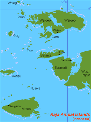
Misool liegt in der Seramsee, im Südwesten des Archipels und südwestlich der Vogelkopfhalbinsel. Nördlich liegen die Inseln Kofiau und Nusela, weiter nach Nordwesten die drei anderen Hauptinseln des Archipels: Salawati, Batanta und Waigeo. Der Archipel gehört zum Regierungsbezirk Raja Ampat der Provinz Papua Barat Daya.
Die höchste Erhebung Misools ist 565 m hoch.
Weblinks
Einzelnachweise
- ↑ Marine Regions · Misool (Island). In: marineregions.org. Abgerufen am 7. Juli 2023.
Auf dieser Seite verwendete Medien
Autor/Urheber: Sentinel-2 cloudless 2016 by EOX IT Services GmbH is licensed under a Creative Commons Attribution 4.0 International License., Lizenz: CC BY-SA 4.0
Misool Island, ID, Sentinel-2
Map (rough) of Raja Ampat islands, Indonesia, own work composed from various mapreferences
(c) Karte: NordNordWest, Lizenz: Creative Commons by-sa-3.0 de
Positionskarte der Molukken und von West-Neuguinea, Indonesien


