Miami and Erie Canal


Der Miami and Erie Canal ist ein stillgelegter Schifffahrtskanal im Westen des US-Bundesstaats Ohio. Er verbindet auf einer Länge von ca. 290 km die Stadt Cincinnati am Ohio River im Süden mit dem Eriesee im Norden, dabei verläuft er auf etwa der Hälfte seiner Länge durch das Tal des Great Miami River. Seitenkanäle führen nach Defiance am Wabash River und zum Grand Lake St. Marys, einem künstlichen See, der als Reservoir für den Miami and Erie Canal angelegt wurde. Einzelne Bauwerke des Kanals wurden in das National Register of Historic Places aufgenommen, darunter die Lockington Locks, sieben Schleusen an bzw. nahe der Scheitelhaltung.
Der Bau des Kanals wurde im Jahr 1825 vom Parlament Ohios beschlossen, er dauerte von 1825 bis 1845. Nach einem Hochwasser 1913 wurden Teile des Kanals zerstört, 1929 wurde er offiziell aufgegeben. Die begonnene, aber aufgegebene Cincinnati Subway folgt teilweise dem zeitgleich mit dem U-Bahn-Bau stillgelegten Miami and Erie Canal.
- Überwucherte Reste des Kanals (2008)
- Stillgelegte Schleuse in Lockington
- Mit einem Pferd getreideltes Boot auf einem erhaltenen Kanalabschnitt in Piqua
Siehe auch
Weblinks
- Kanäle in Ohio, siehe Buchstabe A ( vom 22. Januar 2008 im Internet Archive)
Koordinaten: 39° 6′ 3″ N, 84° 29′ 49″ W
Auf dieser Seite verwendete Medien
(c) Oydman at en.wikipedia, CC BY-SA 3.0
w:Miami and Erie Canal Deep Cut in summer; photograph taken from the Auglaize County portion looking northward into Allen County.
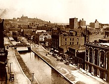
A canal once ran through the heart of Cincinnati. It was drained in 1920.
General Harrison of Piqua canal boat in the Piqua, Ohio Historical Area. This photo shows the captain steering the canal boat and the donkey/ass pulling the boat along the Miami and Erie Canal.
Looking up toward the bottom of the second of the Lockington Locks, located in the southwestern part of the village of Lockington, Ohio, United States. Built in 1833 as a part of the Miami and Erie Canal, the locks are listed on the National Register of Historic Places.
Autor/Urheber: Wholtone, Lizenz: CC BY 3.0
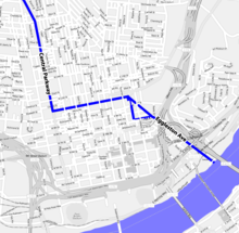
A map showing the former location of the Miami and Erie Canal in downtown Cincinnati. The canal followed modern day Central Parkway until it reached the intersection of Eggleston Ave, at which point it followed Eggleston Ave and cut through Sawyer point and ended in the Ohio River. 1838 bridges at Liberty, 12th, Elm, Race, Vine, Walnut, Main, Sycamore, Court, Broadway, 3rd, and East Front (which no longer exist and is now a part of Sawyer Point) Streets are shown on the map. This map was derived from a free openstreetmap.org map. The location of the bridges and canal was determined from Image:Cincinnati-map-1838.jpg. The triangular section of the canal allowed boats to more easily turn around.


