Metropolregion Tokio

Die Metropolregion Tokio (japanisch 東京大都市圏Tōkyō Dai-toshi-ken, englisch Tokyo Major Metropolitan Area) liegt auf einer Fläche von 13.561[1] Quadratkilometern an der japanischen Pazifikküste und bildet das wirtschaftliche, politische und kulturelle Zentrum des Landes. Japanische Namen dafür sind Tōkyōken (jap. 東京圏; dt. etwa „Tokio-Bereich“), Shutoken (首都圏; dt. etwa „Hauptstadtbereich“), Itto Sanken (一都三県; dt. etwa „eine Metropole, drei Präfekturen“), Minami-Kantō (南関東; dt. etwa „Süd-Kantō“) oder Metropolregion Kantō (関東大都市圏Kantō Dai-toshi-ken), die jedoch nicht synonym sind, sowie auf Englisch Greater Tokyo Area, Tokyo-Yokohama Major Metropolitan Area aka Keihinyo Major Metropolitan Area (京浜葉大都市圏Keihin'yō Dai-toshi-ken).
Ausdehnung und Bevölkerung
Mit rund 38 Millionen Einwohnern (2023) gilt die Region Tokio je nach Definition (vgl. Abschnitt Definitionsvarianten) als größter oder nach dem Perlflussdelta zweitgrößter Ballungsraum der Erde.[2][3] Die vier Millionenstädte Tokio (bzw. die 23 Stadtbezirke), Yokohama, Kawasaki, Saitama sowie Chiba und Sagamihara bilden die Kernstädte. Die Region besteht aus den vier Präfekturen Tokio, Kanagawa, Saitama und Chiba, dehnt sich aber neuerdings auch in die Präfektur Ibaraki aus.
Die Metropolregion ist seit Mitte des 20. Jahrhunderts rasch gewachsen, sowohl nach Fläche wie auch nach Einwohnerzahl. In ihr leben ungefähr 30 Prozent der Gesamtbevölkerung Japans.[1] Ihre äußere Grenze liegt etwa 70 Kilometer vom Stadtzentrum Tokios entfernt. Demgegenüber hat sich seit 1965 die Bevölkerung der 23 Stadtbezirke Tokios verringert, steigt aber seit 1995 durch Reurbanisierung wieder an.
Definitionsvarianten
Unterschiedliche Quellen ziehen die Grenze für die Metropolregion auf unterschiedliche Weise. Je nach Definition schwankt die Einwohnerzahl etwa zwischen 30 und 40 Millionen. Für Wirtschaftsstatistiken hat die Universität Tokio ein „Hauptstadtbeschäftigungsgebiet“ aus Gebieten mit hohem Pendleranteil definiert. Andere Definitionen wie die Region Kantō oder das „Hauptstadtgebiet“ umfassen mehrere Präfekturen als Ganzes.
- Unterschiedliche Definitionen der Region Tokio
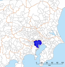 23 Bezirke Tokios (東京23区Tōkyō nijūsan ku; 9,3 Mio. Einwohner, 2015)
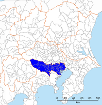
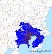 Toshi Koyōken (都市雇用圏, dt. „Hauptstadtbeschäftigungsgebiet“; 35,3 Mio. Einwohner, 2015) der Universität Tokio
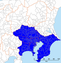
 Metropolregion Kantō (関東大都市圏Kantō Dai-toshi-ken; 36,9 Mio. Einwohner, 2015) des japanischen Statistikamts
 Kantō (関東Kantō; 43,0 Mio. Einwohner, 2015)
 Hauptstadtgebiet (首都圏shutoken; 43,8 Mio. Einwohner, 2015) des Gesetzes zur Sanierung des Hauptstadtgebietes (首都圏整備法shutoken-seibi-hō)
Verkehr und Verwaltung
Eine Hauptaufgabe der Gesamtregion ist der Ausbau der Infrastruktur für den Verkehr in der Metropolregion Tokio und der Betrieb der dortigen öffentlichen Verkehrsmittel.
Eine weitere Aufgabe, der sich die Verwaltung der Metropolregion annimmt, sind die Vorkehrungen angesichts des hohen Erdbebenrisikos. Dafür gibt es gemeinsame Standards für erdbebensicheres Bauen. 92 % der Wohngebäude sind inzwischen so gebaut, dass sie einem Erdbeben der Stärke 7 (gemäß der in Japan gebräuchlichen JMA-Magnituden-Skala) standhalten sollen.[4] Von 2024 bis 2033 will die Metropolregion Tokio umgerechnet 44 Milliarden Euro in den Schutz vor Erdbeben und anderen Naturkatastrophen investieren.[4]
Weblinks
Einzelnachweise
- ↑ a b Statistical Handbook of Japan 2023. (PDF; 4,7 MB) 6. Population Density and Regional Distribution – (2) Population Distribution. Japanisches Statistikamt, 2022, S. 21, abgerufen am 29. Juli 2024 (englisch, Daten aus Tabelle 2.11 – Kanto Major Metropolitan Area: Bevölkerung 38.034 Mio.; 30,2 % der Gesamtbevölkerung; Fläche 13.561 km²; Bevölkerungsdichte 2.804,7 pro km²).
- ↑ Demographia World Urban Areas 19th Annual Edition August 2023 – Schedule 2: Largest Built-Up Urban Areas or World Agglomerations. (PDF; 2,3 MB) In: demographia.com. August 2023, S. 21, abgerufen am 29. Juli 2024 (englisch): „Rank: 1.; Geography: Japan; Urban Area: Tokyo-Yokohama; Population Estimate: 37.785.000“
- ↑ Hannes Taubenböck, Matthias Weigand, Thomas Esch, Jeroen Staab, Michael Wurm, Johannes Mast, Stefan Dech: A new ranking of the world's largest cities—Do administrative units obscure morphological realities? In: Remote Sensing of Environment. Band 232, August 2019, doi:10.1016/j.rse.2019.111353 (englisch, researchgate.net [abgerufen am 29. Juli 2024]).
- ↑ a b Tim Kanning: Wissen, was zu tun ist. Nach dem schweren Erbeben in Japan am Neujahrstag trifft es nun Taiwan. In: Frankfurter Allgemeine Zeitung, 4. April 2024, S. 3.
Auf dieser Seite verwendete Medien

Autor/Urheber: Kenichidon, Lizenz: CC BY-SA 4.0
Map of the Tokyo Urban Employment Area, one of the various definitions of Tokyo/Kanto as of 2015. The definition is from English Wikipedia.

Autor/Urheber: Kzaral, Lizenz: CC BY-SA 4.0
Map of the 23 Special Wards of Tokyo, one of the various definitions of Tokyo/Kanto.
Autor/Urheber:
Chrissib1989
, Lizenz: PD-Schöpfungshöhe
Die Bevölkerungsentwicklung im Ballungsraum Tokio von 1920 - 2007

Autor/Urheber: Kzaral, Lizenz: CC BY-SA 4.0
Map of the South Kanto region, one of the various definitions of Tokyo/Kanto.

Autor/Urheber: Kzaral, Lizenz: CC BY-SA 4.0
Map of the National Capital Region (首都圏) of Japan, one of the various definitions of Tokyo/Kanto. The definition is according to the National Capital Region Planning Act (首都圏整備法). It should be noted that in informal occasions, the word National Capital Region (首都圏) often means much smaller area (Greater Tokyo).

Autor/Urheber: Kzaral, Lizenz: CC BY-SA 4.0
Map of the Tokyo Metropolis, one of the various definitions of Tokyo/Kanto. The map omits Izu/Ogasawara Islands, which is also the part of the metropolis.

Autor/Urheber: Kzaral, Lizenz: CC BY-SA 4.0
Map of the Kanto region, one of the various definitions of Tokyo/Kanto.

Autor/Urheber: Kenichidon, Lizenz: CC BY-SA 4.0
Map of the Kanto Major Metropolitan Area, one of the various definitions of Tokyo/Kanto. The definition is from Japan Statistic Bureau official website. [1]