Mercury (Nevada)
Mercury ist eine Ansiedlung in Nevada, USA nordwestlich von Las Vegas.

In Mercury befinden sich zahlreiche Arbeitsstätten und Wohnquartiere für Beschäftigte der Nevada Test Site. Der Zugang ist für die Öffentlichkeit gesperrt (Kontrolltor). Die Ausfahrt Mercury an der US 95 und das Eingangstor zur Nevada Test Site werden alljährlich zu bestimmten Anlässen (u. a. "Mothers Day") von Demonstranten blockiert, die die Einstellung der Atomtests und die Rückgabe des vom Energieministerium (DoE) beschlagnahmten Landes an die Western Shoshone-Indianer fordern.
1957 wurden in der Nähe von Mercury bei 36°40' nördlicher Breite und 115°59' westlicher Länge Raketen des Typs Asp gestartet zur Untersuchung der Explosionswolken der Atombomben der Operation Plumbbob.
Weblinks
- Mercury in der Encyclopedia Astronautica (englisch)
Koordinaten: 36° 40′ N, 116° 0′ W
Auf dieser Seite verwendete Medien
Autor/Urheber: Finlay McWalter, Lizenz: CC BY-SA 3.0
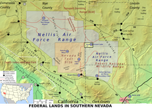
Map of federal lands in southern Nevada, including:
- Nellis Air Force Base
- Area 51
- Tonopah Test Range
- Yucca Mountain
- Mercury
- Nevada Test Site
- Nellis Air Force Range
- Desert National Wildlife Range
- Method of production
- a topographic map was rendered using Demis' mapserver. This combines public domain datasets and renders an image. Demis allows unlimited use of this: [1] says With this statement DEMIS BV grants you permission to freely copy the PNG images returned by our server and use them for your own purposes, including web pages.
- A second version was referenced with the same geometry but with all the available layers turned on. This was used as a guideline for the positions of roads and cities, although the second rendered map is not used in the final rendered image.
- The map was imported in to Inkscape where annotations were drawn in several layers over the bitmap.
- Roads were manually traced from the road lines in the detail map, and cities located from that reference.
- Maps (listed in references) used for reference when placing features (most features are somewhat schematic, with only moderate attention to details of precise size and location).
- Errors
0. Numerous federal land areas are missing
1. Names are outdated
2. The scale is not consistent within the image


