Melalap
| Melalap | ||
|---|---|---|
| Koordinaten | 5° 16′ N, 116° 0′ O | |
| Basisdaten | ||
| Staat | Malaysia | |
| Bundesstaat | Sabah | |
| ISO 3166-2 | MY-12 | |
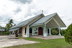
Photo by CEphoto, Uwe Aranas or alternatively © CEphoto, Uwe Aranas, CC BY-SA 3.0 Katholische Kirche von Melalap | ||
Melalap ist ein Dorf im malaysischen Bundesstaat Sabah und gehört zum Verwaltungsbezirk Distrikt Tenom in der Interior Division. In der Kolonialzeit war Melalap durch die hier ansässige Naturkautschuk-Plantage Melalap Rubber Estate bekannt.
Geographie
Melalap liegt am Sungai Melalap, einem rechten Nebenfluss des Sungai Pegalan.
Geschichte
Durch den zu Beginn des 20. Jahrhunderts in Nordborneo einsetzenden Kautschukboom wurde in Melalap eine große Plantage, die Melalap Rubber Estate eröffnet. Dies geschah unter der Voraussetzung, dass die North Borneo Chartered Company die infrastrukturellen Randbedingungen zum Abtransport des Rohkautschuks bereitstellte. Direkt im Anschluss an die Anbindung Tenoms an die North Borneo Railway erfolgte 1906 unter dem Ingenieur Arthur J. West deshalb die Verlängerung der Schienenstrecke um 16 km nach Melalap.
Die Anpflanzung von Kautschukbäumen im Gebiet von Melalap wurde aufgrund der nachhaltig hohen Gewinnmargen auf Ölpalmen umgestellt.
Infrastruktur
Das Dorf liegt an der Bundesstraße SA3 von Tenom nach Keningau. Der Streckenabschnitt Melalap-Tenom der Sabah State Railway wurde bereits 1970 aufgegeben.
Gemeinschaftseinrichtungen
Melalap verfügt über eine Schule, eine Versammlungshalle und eine katholische Kirche.
Literatur
- Owen Rutter: British North Borneo – An Account of its History, Ressources and Native Tribes. Constable & Company, London 1922; archive.org.
- K. G. Tregonning: A History Of Modern Sabah (North Borneo 1881–1963). 2. Ausgabe. University of Malaya Press, Kuala Lumpur 1965, Reprint 1967.
Weblinks
Auf dieser Seite verwendete Medien
Autor/Urheber: Uwe Dedering, Lizenz: CC BY-SA 3.0
Location map of Malaysia.
Equirectangular projection. Strechted by 100.0%. Geographic limits of the map:
* N: 8.0° N
* S: 0.0° N
* W: 99.0° E
* E: 120.0° E
Made with Natural Earth. Free vector and raster map data @ naturalearthdata.com.
Photo by CEphoto, Uwe Aranas or alternatively © CEphoto, Uwe Aranas, CC BY-SA 3.0
Melalap, Sabah, Malaysia: Sekolah Kebangsaan Melalap
Photo by CEphoto, Uwe Aranas or alternatively © CEphoto, Uwe Aranas, CC BY-SA 3.0
Melalap, Sabah, Malaysia: Former Railway Station of North Borneo Railway
Flag of the Malaysian state Sabah. Based on a GIF from a government website, colors from a photo. Drawn by Mysid. The flag was adopted September 16, 1988.
- The mountain on the left is Mount Kinabalu.
Per the Constitution of the State of Sabah:
"The State Flag is in a rectangular shape and is in the proportion of 1:2. The canton which extends at the head half way to the fly and 2/3 at the hoist to the foot is in Icicle Blue (C1T9) as the background to a graphic silhouette of Mount Kinabalu which is in Royal Blue (B10) positioned at ¼ of the height of the canton from end to end. The fly of the flag is divided equally into three bands of colours the foot division of which extends right to the hoist. The top band is in Zircon Blue (C5T5) the second band is in white and the third band is in Chili Red (S6R4)."Photo by CEphoto, Uwe Aranas or alternatively © CEphoto, Uwe Aranas, CC BY-SA 3.0
Melalap, Sabah, Malaysia: Catholic Church (Gereja Katolik) Melalap


