Matureivavao
| Matureivavao | ||
|---|---|---|
| NASA-Bild von Matureivavao | ||
| Gewässer | Pazifischer Ozean | |
| Archipel | Actéon-Inseln, Tuamotu-Archipel | |
| Geographische Lage | 21° 29′ S, 136° 25′ W | |
| Anzahl der Inseln | – | |
| Landfläche | 3,96 km² | |
| Lagunenfläche | 18 km² | |
| Gesamtfläche | 28,62 km² | |
| Einwohner | unbewohnt | |
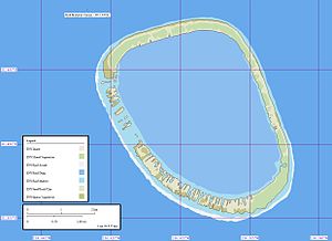
| Karte des Atolls | ||
Matureivavao (alter Name: Melbourne Island) ist ein Atoll des Tuamotu-Archipels in Französisch-Polynesien. Matureivavao ist das östlichste und größte Atoll der Actéon-Inseln. Matureivavao liegt 15 km westlich von Marutea Sud und 15 km südöstlich von Vahanga entfernt, die Lagune des Atolls hat keinen schiffbaren Eingang zum Meer. Administrativ gehört Matureivavao zur Gemeinde Gambier.
Die Gesamtfläche beträgt 28,62 km² (Landfläche, Riff und Lagune).[1]
Auf Matureivavao stehen einige Häuser, es ist jedoch nicht bewohnt. Bei schlechtem Wetter schwappt das Meer über das Atoll. Der Sandstrand des Atolls ist von einer üppigen Vegetation begrenzt.
Literatur
- Sailing Directions. Pub 126, Pacific Islands NIMA 2002, S. 12.
Weblinks
- Vogelwelt des Atolls (englisch)
- Fauna und Flora des Atolls (PDF, englisch)
- Bild und Kurzbeschreibung (englisch) (Memento vom 23. Dezember 2010 im Internet Archive)
Einzelnachweise
Auf dieser Seite verwendete Medien
Autor/Urheber: Eric Gaba (Sting - fr:Sting), Lizenz: CC BY-SA 3.0
Blank physical map of the overseas collectivity of French Polynesia, France, for geo-location purpose.
Autor/Urheber: User:Zscout370, Lizenz: CC BY-SA 2.5
The flag of the Tuamotu Islands (Tuamotu and Gambier Islands, French Polynesia). SVG file created by me.
Karte des Matureivavao-Atolls, Tuamotu-Archipel, Französisch-Polynesien
NASA-Astronautenbild des Atolls Matureivavao (Tuamotu-Archipel, Französisch-Polynesien) im Pazifischen Ozean


