Marion County (Texas)
 Das Marion County Courthouse in Jefferson | |
| Verwaltung | |
|---|---|
| US-Bundesstaat: | Texas |
| Verwaltungssitz: | Jefferson |
| Adresse des Verwaltungssitzes: | Marion County Courthouse P.O. Box 763 Jefferson, TX 75657-0420 |
| Gründung: | 1860 |
| Gebildet aus: | Cass County |
| Vorwahl: | 001 903 |
| Demographie | |
| Einwohner: | 9.725 (Stand: 2020) |
| Bevölkerungsdichte: | 9,84 Einwohner/km2 |
| Geographie | |
| Fläche gesamt: | 1089 km² |
| Wasserfläche: | 101 km² |
| Karte | |
 | |
| Website: www.co.marion.tx.us | |
Das Marion County[1] ist ein County im US-Bundesstaat Texas. Das U.S. Census Bureau hat bei der Volkszählung 2020 eine Einwohnerzahl von 9.725[2] ermittelt. Der Sitz der County-Verwaltung (County Seat) befindet sich in Jefferson.[3]
Geographie
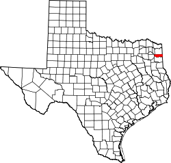
Das County liegt im Nordosten von Texas an der Grenze zu Louisiana und etwa 10 km von der Grenze zu Arkansas. Es hat eine Fläche von 1089 Quadratkilometern, wovon 101 Quadratkilometer Wasserfläche sind. Es grenzt an folgende Countys und Parishes:
| Morris County | Cass County | |
| Upshur County |  | Caddo Parish (Louisiana) |
| Harrison County |
Geschichte
Das Marion County wurde am 8. Februar 1860 aus Teilen des Cass County gebildet. Benannt wurde es nach Francis Marion (1732–1795), einem General im amerikanischen Unabhängigkeitskrieg mit dem Spitznamen “Swamp Fox” („Sumpf-Fuchs“) und Mitglied im Senat von South Carolina.[4]

18 Bauwerke und Bezirke im County sind im National Register of Historic Places („Nationales Verzeichnis historischer Orte“; NRHP) eingetragen (Stand 27. November 2021), darunter das Alley-Carlson House, der Jefferson Historic District und das Old U.S. Post Office and Courts Building.[5]
Demografische Daten
| Bevölkerungswachstum | |||
|---|---|---|---|
| Census | Einwohner | ± rel. | |
| 1860 | 3.977 | — | |
| 1870 | 8.562 | 115,3 % | |
| 1880 | 10.983 | 28,3 % | |
| 1890 | 10.962 | −0,2 % | |
| 1900 | 10.754 | −1,9 % | |
| 1910 | 10.472 | −2,6 % | |
| 1920 | 10.886 | 4 % | |
| 1930 | 10.371 | −4,7 % | |
| 1940 | 11.457 | 10,5 % | |
| 1950 | 10.172 | −11,2 % | |
| 1960 | 8.049 | −20,9 % | |
| 1970 | 8.517 | 5,8 % | |
| 1980 | 10.360 | 21,6 % | |
| 1990 | 9.984 | −3,6 % | |
| 2000 | 10.941 | 9,6 % | |
| 2010 | 10.546 | −3,6 % | |
| 2020 | 9.725 | −7,8 % | |
| 1860–2010[6] 2020[7] | |||


Nach der Volkszählung im Jahr 2010 lebten im Marion County 10.546 Menschen in 4.989 Haushalten. Die Bevölkerungsdichte betrug 10,7 Einwohner pro Quadratkilometer.
Ethnisch betrachtet setzte sich die Bevölkerung zusammen aus 73,5 Prozent Weißen, 22,0 Prozent Afroamerikanern, 0,8 Prozent amerikanischen Ureinwohnern, 0,5 Prozent Asiaten sowie aus anderen ethnischen Gruppen; 2,1 Prozent stammten von zwei oder mehr Ethnien ab. Unabhängig von der ethnischen Zugehörigkeit waren 3,1 Prozent der Bevölkerung spanischer oder lateinamerikanischer Abstammung. In den 4.989 Haushalten lebten statistisch je 2,09 Personen.
20,0 Prozent der Bevölkerung waren unter 18 Jahre alt, 58,8 Prozent waren zwischen 18 und 64 und 21,2 Prozent waren 65 Jahre oder älter. 51,6 Prozent der Bevölkerung war weiblich.
Das jährliche Durchschnittseinkommen eines Haushalts lag bei 31.210 USD. Das Prokopfeinkommen betrug 19.082 USD. 24,6 Prozent der Einwohner lebten unterhalb der Armutsgrenze.[8]
Städte, Gemeinden und andere Ortschaften
|
|
|
Siehe auch
Einzelnachweise
- ↑ Marion County. In: Geographic Names Information System. United States Geological Survey, United States Department of the Interior (englisch). Abgerufen am 22. Februar 2011
- ↑ Explore Census Data Total Population in Marion County, Texas. Abgerufen am 5. März 2023.
- ↑ National Association of Counties Abgerufen am 10. Oktober 2011
- ↑ Charles Curry Aiken, Joseph Nathan Kane: The American Counties: Origins of County Names, Dates of Creation, Area, and Population Data, 1950–2010. 6. Auflage. Scarecrow Press, Lanham 2013, ISBN 978-0-8108-8762-6, S. 194.
- ↑ Suchmaske Datenbank im National Register Information System. National Park Service, abgerufen am 27. November 2021.
Weekly List im National Register Information System. National Park Service, abgerufen am 27. November 2021. - ↑ Texas Almanac: Population History of Countys from 1850–2010 (PDF; 698 kB), abgerufen am 18. September 2012.
- ↑ Eintrag bei Census.gov. Abgerufen am 27. November 2021.
- ↑ U.S. Census Buero, State & County QuickFacts - Marion County (Memento des vom 14. Juli 2011 auf WebCite) Info: Der Archivlink wurde automatisch eingesetzt und noch nicht geprüft. Bitte prüfe Original- und Archivlink gemäß Anleitung und entferne dann diesen Hinweis. Abgerufen am 10. Oktober 2011
Weblinks
- Yahoo Bildersuche - Marion County
- Marion County im Handbuch von Texas
- Offizielle Website
- "Marion County Profile" der Texas Association of Counties
- U.S. Census Buero, State & County QuickFacts - Marion County
- www.city-data.com - Marion County
Koordinaten: 32° 48′ N, 94° 22′ W
Auf dieser Seite verwendete Medien
This is a locator map showing Marion County in Texas. For more information, see Commons:United States county locator maps.
Lake O’ the Pines on Big Cypress Bayou, Marion County, Texas, USA. The lake is impounded by Ferrells Bridge Dam, a concrete-and-earthfill dam that is over 2 miles (3.2 km) long. The U.S. Army Corps of Engineers constructed the dam in 1951 for flood control and water supply.
Autor/Urheber: Renelibrary, Lizenz: CC BY-SA 4.0
Alley-Carlson House in Jefferson, Texas
The spillway at Ferrells Bridge Dam, impounding Lake O’ the Pines on Big Cypress Bayou, Marion County, Texas, USA. The concrete-and-earthfill dam is over 2 miles (3.2 km) long and this picture shows only the spillway of the dam. The U.S. Army Corps of Engineers constructed the dam in 1951 for flood control and water supply. View is to the north.
Autor/Urheber: Renelibrary, Lizenz: CC BY-SA 4.0
Marion County Courthouse in Jefferson, Texas
Autor/Urheber:
- real name: Artur Jan Fijałkowski
- pl.wiki: WarX
- commons: WarX
- mail: [1]
- jabber: WarX@jabber.org
- irc: [2]
- software: own perl scripts
Age pyramid for Marion County, Texas, United States of America, based on census 2000 data


