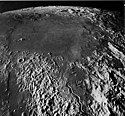
Mare Vaporum
| Mare Vaporum | ||
|---|---|---|
 | ||
| Mare Vaporum in der Draufsicht. In der oberen Bildmitte Lacus Felicitatis. | ||
| Position | 13,57° N, 3,69° O | |
| Durchmesser | 242 km | |
| Siehe auch Gazetteer of Planetary Nomenclature | ||
Das Mare Vaporum (Lat. „Meer der Dünste“) ist ein Mondmeer auf dem Erdmond. Es hat die selenographischen Koordinaten 14° N 4° E und einen mittleren Durchmesser von 240 km.
Es befindet sich südwestlich des Mare Serenitatis und südöstlich des Mare Imbrium. Das Meer wird durch den Höhenzug Montes Apenninus begrenzt.
Südlich vom Mare Vaporum am Mondkrater Ukert kann beim Mondalter von zirka 6,7 Tagen, kurz vor dem Erreichen des ersten Mondviertels der visuelle Effekt Lunar V am Mondterminator beobachtet werden.
Weblinks
- Lunar.arc.nasa.gov: Mare Vaporum (englisch)
- Spektrum.de: Amateuraufnahmen [1]
- The-moon.wikispaces.com: Mare Vaporum (englisch)
Auf dieser Seite verwendete Medien
Apollo, AS17-1674 (M) (Altitude: 104km): It is common for the circular form of a very old basin to survive even after all basin materials are obliterated. Mare Vaporum, as shown in this south looking oblique photograph, provides a good example. Its average width is about 200 km. Its circular form marks the outer edge of the ancient, deeply buried Vaporum basin. All the terrae surrounding Mare Vaporum are blanketed by massive ejecta of the Imbrium basin, the center of which lies to the north, behind and to the right of the camera. The ejecta disappears beneath Mare Vaporum. The circularity is enhanced at the left (east) of the picture by a system of mare ridges and scarps that was localized over an old Vaporum basin ring. The cratered, linear Hyginus Rille is near the southern horizon, and the sinuous Conon Rille, to be described later in this book, is in the foreground. (Figure 35 in: H. Masursky, G.W. Colton, and F. El-Baz (eds.) (1978). Apollo over the moon: A view from orbit. NASA, Washington DC)
Mare Vaporum, the "Sea of Vapors", is located between the southwest rim of Mare Serenitatis, and the southeast rim of Mare Imbrium. The lunar material surrounding the mare is from the Lower Imbrian epoch, and the mare material is from the Eratosthenian epoch. The mare lies in an old basin or crater that is within the Procellarum basin. The crater Manilius can be seen as the bright circular object to the right of the mare. You can barely make out some of the rays coming off of the crater. To the south is a light colored thin line. This feature is Rima Hyginus. In the upper left side of the photo is the mountain range Montes Apenninus.
NASA lunar chart of equatorial region (latitudes 45S to 45N) 1 : 10.000.000 (LPC-1).


