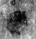
Mare Smythii
| Mare Smythii | ||
|---|---|---|
 | ||
| Position | 1,71° S, 87,05° O | |
| Durchmesser | 374 km | |
| Benannt nach | Smyth, William Henry; British astronomer (1788–1865). | |
| Siehe auch Gazetteer of Planetary Nomenclature | ||
Das Mare Smythii (Lat. „Smyth-Meer“; nach William Henry Smyth) ist ein Mondmeer auf dem Erdmond.
Es hat einen mittleren Durchmesser von 373 km und weist ein Mascon auf.
Das Mare befindet sich am Äquator an der östlichen Grenze zur erdabgewandten Mondseite, auf den selenographischen Koordinaten 1° 18' N; 87° 30' E.
Weblinks
- Lunar.arc.nasa.gov: Mare Smythii (englisch)
- Mare Smythii im The Moon-Wiki (englisch)

Auf dieser Seite verwendete Medien
NASA lunar chart of equatorial region (latitudes 45S to 45N) 1 : 10.000.000 (LPC-1).
Autor/Urheber: Martin Pauer (Power), Lizenz: CC BY-SA 3.0
Vergleich der Topographie der Oberfläche (oben) und des Gravitationsfeldes.
en:Mare Smythii is located along the equator on the easternmost edge of the near side. The Smythii basin where the mare is located is of the Pre-Nectarian epoch, while the surrounding features are of the Nectarian system. The mare material, which make up the floor of the mare, is a high alumious basalt, and consists of Upper Imbrian basalt covered by Eratosthenian basalt. The Crater located to the north of the mare, at the top of the photo, is Neper. This crater makes up part of the southern rim of Mare Marginis. Just off to the northwest of the mare are the craters Schubert (top) and Schubert B (bottom). The dark mare filled crater at the southern edge of Smythii is the crater Kastner.


