Manorcunningham
| Manorcunningham Mainéar Uí Chuinneagáin Manorcunningham | |||
|---|---|---|---|
| |||
| Koordinaten | 54° 57′ 12″ N, 7° 37′ 16″ W | ||
| Basisdaten | |||
| Staat | Irland | ||
| Provinz | Ulster | ||
| Grafschaft | Donegal | ||
| ISO 3166-2 | IE-DL | ||
| Höhe | 43 m | ||
| Fläche | 0,5 km² | ||
| Einwohner | 830 (2022[1]) | ||
| Dichte | 1.645,5 Ew./km² | ||
| Postleitzahl | F92 | ||
| Telefonvorwahl | +353 (0)74 | ||
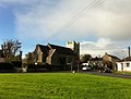
 (c) Kenneth Allen, CC BY-SA 2.0 Manorcunningham, Ortszentrum | |||
Manorcunningham (irisch Mainéar Uí Chuinneagáin, deutsch: „Herrenhaus des [Forts des] Ó Cuinneagáin“) ist ein Dorf im County Donegal (Republik Irland) mit 830 Einwohnern (Stand 2022[1]).
Lage
Manorcunningham liegt etwa sieben Kilometer östlich von Letterkenny am Ästuar des River Corkey. Durch die Ortschaft führt die N13 von Letterkenny nach Derry. Von hier gehrt die N14 nach Lifford ab.
Sehenswürdigkeiten
- anglikanische Kirche
- Pluck Standing Stone National Monument
 Anglikanische Kirche
Weblinks
Einzelnachweise
- ↑ a b Manorcunningham auf citypopulation.de, abgerufen am 20. April 2025
| Towns | Ballybofey | Ballyshannon | Buncrana | Bundoran | Carndonagh | Castlefin | Donegal | Dungloe | Falcarragh | Glenties | Killybegs | Letterkenny | Lifford | Ramelton | Stranorlar | |
| Dörfer | Annagry | Ardara | Ballindrait | Ballintra | Ballyliffin | Bridgend | Bruckless | Burnfoot | Burtonport | Carrick | Carrigans | Carrigart | Churchill | Cloghan | Clonmany | Convoy | Cranford | Creeslough | Crolly | Culdaff | Doochary | Downings | Drumkeen | Dunfanaghy | Dunkineely | Dunlewey | Fahan | Fintown | Frosses | Glen | Glencolmcille | Greencastle | Inver | Kerrykeel | Kilcar | Killea | Killygordon | Kilmacrennan | Laghy | Leabgarrow | Lettermacaward | Loughanure | Malin | Malin Beg | Manorcunningham | Meenlaragh | Milford | Mountcharles | Moville | Muff | Narin | Newtowncunningham | Pettigo | Porthall | Portnablagh | Quigley’s Point | Raphoe | Rathmullan | Redcastle | Rossnowlagh | Shrove | St. Johnston | Teelin | Termon |
Auf dieser Seite verwendete Medien

(c) Karte: NordNordWest, Lizenz: Creative Commons by-sa-3.0 de
Positionskarte von Irland
(c) Kenneth Allen, CC BY-SA 2.0
Road at Manorcunningham Buildings to the right include the Post Office and a hair salon

Autor/Urheber: Dana2011, Lizenz: CC BY-SA 3.0
A church in Manorcunningham, Co Donegal, Ireland

Autor/Urheber:
- Island_of_Ireland_location_map.svg: *Ireland_location_map.svg: NordNordWest
- Northern_Ireland_location_map.svg: NordNordWest
- Northern_Ireland_-_Counties.png: Maximilian Dörrbecker (Chumwa)
- derivative work: Rannpháirtí anaithnid (talk)
- derivative work: Mabuska (talk)
The island of Ireland, showing international border between Ireland and Northern Ireland, traditional provinces, traditional counties, and local authority areas in Ireland and Northern Ireland.