Mandakini
| Mandakini | ||
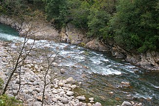
Mandakini nahe Guptakashi | ||
| Daten | ||
| Lage | Uttarakhand (Indien) | |
| Flusssystem | Ganges | |
| Abfluss über | Alaknanda → Ganges → Indischer Ozean | |
| Ursprung | Chorabarigletscher 30° 44′ 45″ N, 79° 3′ 50″ O | |
| Quellhöhe | 3865 m | |
| Mündung | Alaknanda bei RudraprayagKoordinaten: 30° 17′ 15″ N, 78° 58′ 40″ O 30° 17′ 15″ N, 78° 58′ 40″ O | |
| Mündungshöhe | ca. 600 m | |
| Höhenunterschied | ca. 3265 m | |
| Sohlgefälle | ca. 47 ‰ | |
| Länge | ca. 70 km | |
| Linke Nebenflüsse | Kaliganga, Madhyamaneshwar | |
| Kleinstädte | Rudraprayag | |
| Gemeinden | Kedarnath, Gaurikund | |
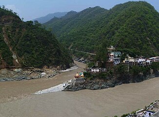
Mündung des Mandakini in die Alaknanda | ||
Der Mandakini (Hindi:मंदाकिनी) ist ein rechter Nebenfluss der Alaknanda, dem linken Quellfluss des Ganges, im Himalaya im indischen Bundesstaat Uttarakhand.
Das Quellgebiet des Mandakini liegt an der Südflanke des Berges Kedarnath im Süden der Gangotri-Gruppe im Garhwal-Himalaya auf einer Höhe von 3865 m. Der Fluss wird vom Chorabarigletscher gespeist. Nahe der Quelle liegt der hinduistische Wallfahrtsort Kedarnath. Der Mandakini fließt in überwiegend südlicher Richtung durch den Distrikt Rudraprayag und mündet schließlich bei der Distrikthauptstadt Rudraprayag in die Alaknanda. Der Mandakini hat eine Länge von ca. 70 km.
Weblinks
Auf dieser Seite verwendete Medien
Autor/Urheber: Mukerjee, Lizenz: CC BY-SA 3.0
confluence of Alaknanda (bottom, flowing in from right) and Mandakini River (flowing in from top - North) at Rudraprayag. the Chamundi mandir (temple) at the confluence can be seen. the scene is almost unrecognizable compared to what it was like before 17 June 2013. there used to be a footbridge (jhula) over the mandakini that was washed away in the 2013 Uttarakhand floods. the stones at the bottom of the stairs were not there, and there was a viewing gallery, and a very large rock called the Narad Shila.
Autor/Urheber: Vvnataraj, Lizenz: CC BY-SA 3.0
Mandakini near town of Guptakashi


