Malinao (Vulkan)
| Malinao | ||
|---|---|---|
 | ||
| Höhe | 1548 m | |
| Lage | Insel Luzon, Philippinen | |
| Gebirge | Einzel stehender Berg | |
| Koordinaten | 13° 24′ 11″ N, 123° 36′ 28″ O | |
| Typ | Stratovulkan | |
| Gestein | Andesit | |
| Letzte Eruption | vor 60.000 Jahren | |
Der Malinao, auch Buhi oder Takit, ist ein 1548 m hoher Stratovulkan auf den Philippinen. Er liegt an der Grenze der Provinzen Albay und Camarines Sur, in der Region Bicol, auf der Insel Luzon in der Nähe der Vulkane Mayon und Masaraga.
Der bewaldete Berg wird als erloschener Stratovulkan beschrieben, der vor 500.000 bis 60.000 Jahren aktiv war, also im Quartär. An der Ostseite des Vulkans befinden sich die ausgedehntesten Geothermalquellenfelder auf der Insel Luzon. Zwei ausgedehnte Thermalquellenfelder sind das Naglabong- und das Tiwi-Thermalquellenfeld.
Weblinks
- Malinao (Vulkan) im Global Volcanism Program der Smithsonian Institution (englisch)
- https://www.mountain-forecast.com/peaks/Mt-Malinao
Auf dieser Seite verwendete Medien
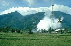
Mount Malinao is a forested stratovolcano with a summit crater that is breached to the east. The Tiwi geothermal field, seen here with the volcano in the background, is located on the east flanks of Malinao. The geothermal field is located near Luzon's largest fumarole field, which includes siliceous sinter deposits at Naglabong.
Autor/Urheber: Carport, Lizenz: CC BY-SA 3.0
Physische Positionskarte der Philippinen


