Mae Nam Mae Klong
| Mae Nam Mae Klong Mae Klong | ||
 | ||
| Daten | ||
| Lage | Zentralthailand | |
| Flusssystem | Mae Nam Mae Klong | |
| Ursprung | Zusammenfluss von Khwae Noi und Khwae Yai bei Kanchanaburi 14° 1′ 5″ N, 99° 31′ 40″ O | |
| Mündung | In der Provinz Samut Songkhram in den Golf von ThailandKoordinaten: 13° 21′ 46″ N, 100° 0′ 1″ O 13° 21′ 46″ N, 100° 0′ 1″ O
| |
| Länge | 140 km | |
Der Mae Nam Mae Klong (Thai:แม่น้ำแม่กลอง, Aussprache:[mɛ̂ː náːm mɛ̂ː klɔːŋ]), oder nur Mae Klong, ist ein Fluss im westlichen Teil der Zentralregion von Thailand. Der Fluss beginnt am Zusammenfluss von Khwae Noi und Khwae Yai bei Kanchanaburi. Er mündet später in der Provinz Samut Songkhram in den Golf von Thailand.
Der Fluss ist 140 Kilometer lang.
In den 1960er-Jahren wurde der Oberlauf des Flusses bis zur Provinzhauptstadt Kanchanaburi in Khwae Yai (แม่น้ำแควใหญ่, „Großer Nebenfluss“) umbenannt, da bis dahin die berühmte Brücke über den Kwai über den Mae Klong und nicht über den Fluss Khwae (Kwai) führte.

Mae Klong

Mae Klong bei Samut Songkhram

Mae Klong
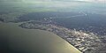
Mündung des Mae Klong in Samut Songkhram
Weblinks
Commons: Mae Klong – Sammlung von Bildern, Videos und Audiodateien
Auf dieser Seite verwendete Medien

Mae Klong in Samut Songkhram.jpg
Autor/Urheber:
Mae Klong in Samut Songkhram, Thailand.
Autor/Urheber:
ผู้สร้างสรรค์ผลงาน/ส่งข้อมูลเก็บในคลังข้อมูลเสรีวิกิมีเดียคอมมอนส์ - เทวประภาส มากคล้าย
,
Lizenz: CC BY 2.5
Mae Klong in Samut Songkhram, Thailand.


Mouth of the Mae Klong River aerial view.jpg
Autor/Urheber: Paul_012, Lizenz: CC BY-SA 3.0
Aerial photograph of the mouth of the Mae Klong in Samut Songkhram Province, Thailand. Sunlight reflected in water surfaces show the numerous coastal prawn farms and salt works in the area.
Autor/Urheber: Paul_012, Lizenz: CC BY-SA 3.0
Aerial photograph of the mouth of the Mae Klong in Samut Songkhram Province, Thailand. Sunlight reflected in water surfaces show the numerous coastal prawn farms and salt works in the area.