Mackay-Gletscher
| Mackay-Gletscher | ||
|---|---|---|
| Lage | Viktorialand, Ostantarktika | |
| Gebirge | Transantarktisches Gebirge | |
| Koordinaten | 76° 58′ S, 162° 0′ O | |
| ||
| Entwässerung | Granite Harbor | |
Der Mackay-Gletscher ist ein mächtiger antarktischer Gletscher, der vom Polarplateau im Viktorialand in östliche Richtung zwischen der Convoy und der Clare Range fließt. An der Scott-Küste mündet er im südlichen Bereich des Granite Harbor in Form einer markanten Gletscherzunge[1] ins Rossmeer.
Der Gletscher wurde von Teilnehmern der Nimrod-Expedition (1907–1909) unter der Leitung des britischen Polarforschers Ernest Shackleton entdeckt. Benannt ist er nach dem schottischen Arzt Alistair Mackay (1878–1914), einem Teilnehmer der Expedition.
Siehe auch
Weblinks
- Mackay Glacier. In: Geographic Names Information System. United States Geological Survey, United States Department of the Interior, archiviert vom (englisch).
- Mackay Glacier auf geographic.org (englisch)
- Mackay Glacier. In: Kenneth J. Bertrand und Fred G. Alberts, Geographic names of Antarctica, U.S. Govt. Print. Off., Washington 1956, S. 200 (englisch)
Einzelnachweise
- ↑ Williamson Glacier Tongue. In: Geographic Names Information System. United States Geological Survey, United States Department of the Interior, archiviert vom (englisch).
Mackay Glacier Tongue auf geographic.org (englisch)
Landkarten
 Mittelteil des Mackay-Gletschers im Südosten der Karte
 Zunge des Mackay-Gletschers im Südwesten der Karte
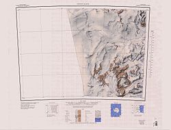
 Westteil des Mackay-Gletschers im Norden der Karte
Auf dieser Seite verwendete Medien

C77198s1 Ant.Map Taylor Glacier.jpg
1:250,000-scale topographic reconnaissance map of the Taylor Glacier area from 156°-162'E to 77°-78°S in Antarctica. Mapped, edited and published by the U.S. Geological Survey in cooperation with the National Science Foundation.
1:250,000-scale topographic reconnaissance map of the Taylor Glacier area from 156°-162'E to 77°-78°S in Antarctica. Mapped, edited and published by the U.S. Geological Survey in cooperation with the National Science Foundation.

Antarctica relief location map.jpg
Autor/Urheber: Alexrk2, Lizenz: CC BY-SA 3.0
Physische Positionskarte Antarktis, Mittabstandstreue Azimutalprojektion
Autor/Urheber: Alexrk2, Lizenz: CC BY-SA 3.0
Physische Positionskarte Antarktis, Mittabstandstreue Azimutalprojektion

C76198s1 Ant.Map Convoy Range.jpg
1:250,000-scale topographic reconnaissance map of the Convoy Range area from 156°-162'E to 76°-77°S in Antarctica. Mapped, edited and published by the U.S. Geological Survey in cooperation with the National Science Foundation.
1:250,000-scale topographic reconnaissance map of the Convoy Range area from 156°-162'E to 76°-77°S in Antarctica. Mapped, edited and published by the U.S. Geological Survey in cooperation with the National Science Foundation.

C76191s1 Ant.Map Franklin Island.jpg
Map of Antarctica by the United States Antarctic Resource Center of the US Geological Society.
Map of Antarctica by the United States Antarctic Resource Center of the US Geological Society.