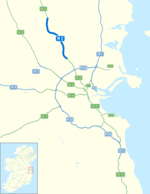
M2 motorway (Irland)
| M2 motorway in Irland | ||||||||||||||||||||||
 | ||||||||||||||||||||||
| Karte | ||||||||||||||||||||||
 | ||||||||||||||||||||||
| Basisdaten | ||||||||||||||||||||||
| Betreiber: | Transport Infrastructure Ireland | |||||||||||||||||||||
| Straßenbeginn: | M50 motorway (Irland) Junction 5 | |||||||||||||||||||||
| Straßenende: | Ashbourne | |||||||||||||||||||||
| Gesamtlänge: | 12,5 km | |||||||||||||||||||||
 | ||||||||||||||||||||||
| Anfang der M2 bei Ashbourne | ||||||||||||||||||||||
Straßenverlauf
| ||||||||||||||||||||||

Der M2 motorway (englisch für „Autobahn M2“, irisch Mótarbhealach M2) ist eine 12,5 km lange, nicht mautpflichtige hochrangige Straßenverbindung in der Republik Irland, die vom Dubliner Autobahnring M50 motorway über ein 4,1 km langes Verbindungsstück der Nationalstraße N2 nach Nordnordwesten Richtung Ardee und Carrickmacross führt; die N2 führt in Irland weiter nach Monaghan und überschreitet dann die Grenze zu Nordirland.[1]
Weblinks
Einzelnachweise
- ↑ Ordnance Survey Ireland/Ordnance Survey Northern Ireland (Hrsg.): Official Road Atlas Ireland/Atlas oifigiúil Bóitre Éireann, 7th Edition 2018, ISBN 978-1-908852-83-0
Auf dieser Seite verwendete Medien
Autobahnkreuz (Icon) in blau.
Autor/Urheber: Dake (Diskussion · Beiträge), Booyabazooka (Diskussion · Beiträge), Roulex 45 (Diskussion · Beiträge), and Doodledoo (Diskussion · Beiträge), Lizenz: CC BY-SA 2.5
Dieses Bild wurde in der Grafikwerkstatt (fr) überarbeitet. Du kannst dort ebenfalls Bilder vorschlagen, die zu überarbeiten, verändern oder übersetzen sind.
M2 Motorway Symbol Ireland
Autor/Urheber: Sswonk (talk), Lizenz: CC BY-SA 3.0
Map of M2 motorway (Ireland) and Dublin area roads with M2 blue bolded, Nxx routes in green and Mxx routes in blue
"Picture of M2 RCS"
Dálniční ukazatele u Kilkshane
M50 Motorway Symbol Ireland
Irish National Route shield
Ireland regional road shield


