Møre og Romsdal
| Wappen | Karte |
|---|---|
 | (c) Karte: NordNordWest, Lizenz: Creative Commons by-sa-3.0 de |
| Basisdaten | |
| Land: | Norwegen |
| Verwaltungszentrum: | Molde |
| Fläche: | 14.356 km² (1. Januar 2025) |
| Einwohner: | 272.413 (1. Januar 2025) |
| Bevölkerungsdichte: | 19 Einw. pro km² |
| Kommunen: | 27 |
| ISO 3166-2 | NO-15 |
| Internet: | Møre og Romsdal |
| Politik | |
| Fylkesordfører: | Anders Riise (2023) |
| Statsforvalter: | Else-May Botten |
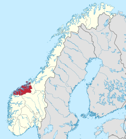
Møre og Romsdal ist die nördlichste Provinz (Fylke) der Region Vestlandet in Norwegen. Dort leben 272.413 Einwohner (1. Januar 2025) in 26 Kommunen auf einer Fläche von 14.359 Quadratkilometern bei einer Bevölkerungsdichte von 18,5 Einwohnern pro Quadratkilometer. Ihre Hauptstadt ist Molde, größte Gemeinde ist jedoch Ålesund. Møre og Romsdal grenzt an die Provinzen Innlandet, Trøndelag und Vestland.
Vor der Reform von 1919 hieß die Provinz Romsdals amt und war in die Vogteien (fogderi) Nordmøre, Romsdal und Sunnmøre eingeteilt. Per 1919 wurde es in Møre umbenannt, 1935 erhielt es den heute noch gültigen Doppelnamen. Das Wappen des Distrikts zeigt drei stilisierte Wikingerschiffe, eines für jede Vogtei.
Der Nordosten, also Romsdal, wird in mancher Hinsicht auch zusammen mit Trøndelag als Mittelnorwegen betrachtet.
Kommunen
Zum 1. Januar 2019 wechselte Rindal ins Fylke Trøndelag. Zum 1. Januar 2020 gab es folgende Gemeindezusammenlegungen:
- Haram, Sandøy, Skodje und Ørskog zu Ålesund
- Midsund und Nesset zu Molde
- Norddal und Stordal zu einer neuen Gemeinde Fjord
- Fræna und Eide zu einer neuen Gemeinde Hustadvika
Außerdem wechselte die Kommune Hornindal aus Sogn og Fjordane und fusioniert mit Volda. Halsa hingegen vereinigte sich mit Hemne und einem Teil von Snillfjord, beide in Trøndelag, zu Heim und verließ damit Møre og Romsdal.[1]
Zum 1. Januar 2024 wurde Haram wieder eigenständig.
(c) Karte: NordNordWest, Lizenz: Creative Commons by-sa-3.0 de
|
| Kommunen- nummer | Karte | Name | Einwohner (1. Januar 2025) | Fläche (km²) | Sprach- form |
|---|---|---|---|---|---|
| 1505 | Kristiansund | 24.578 | 87,44 | neutral | |
| 1506 | Molde | 33.163 | 1.503,36 | neutral | |
| 1508 | Ålesund | 59.198 | 371,34 | neutral | |
| 1511 | Vanylven | 3048 | 385,11 | Nynorsk | |
| 1514 | Sande | 2435 | 93,24 | Nynorsk | |
| 1515 | Herøy | 9031 | 119,53 | Nynorsk | |
| 1516 | Ulstein | 8862 | 97,2 | Nynorsk | |
| 1517 | Hareid | 5320 | 82,27 | Nynorsk | |
| 1520 | Ørsta | 11.055 | 661,58 | Nynorsk | |
| 1525 | Stranda | 4380 | 865,86 | Nynorsk | |
| 1528 | Sykkylven | 7626 | 337,8 | Nynorsk | |
| 1531 | Sula | 9759 | 58,51 | Nynorsk | |
| 1532 | Giske | 8773 | 40,58 | Nynorsk | |
| 1535 | Vestnes | 7242 | 404,59 | neutral | |
| 1539 | Rauma | 7196 | 1.449,26 | neutral | |
| 1547 | Aukra | 3759 | 60,66 | Nynorsk | |
| 1554 | Averøy | 5992 | 175,7 | neutral | |
| 1557 | Gjemnes | 2708 | 381,63 | neutral | |
| 1560 | Tingvoll | 3077 | 336,81 | neutral | |
| 1563 | Sunndal | 7193 | 1.713,37 | neutral | |
| 1566 | Surnadal | 5950 | 1.366,03 | Nynorsk | |
| 1573 | Smøla | 2168 | 271,91 | neutral | |
| 1576 | Aure | 3394 | 641,28 | neutral | |
| 1577 | Volda | 11.131 | 876,87 | Nynorsk | |
| 1578 | Fjord | 2506 | 1.190,58 | Nynorsk | |
| 1579 | Hustadvika | 13.460 | 521,93 | neutral | |
| 1580 | Haram | 9409 | 261,19 | neutral | |
| 15 | Møre og Romsdal | 272.413 | 14.355,63 | Nynorsk |
Weblinks
- Aktuelle Webpräsenz auf mrfylke.no
- Møre og Romsdal auf snl.no im Store Norske Leksikon (norwegisch)
- Geschichtliches zu Møre og Romsdal ( vom 19. August 2006 im Internet Archive)
Nachweise
- ↑ Navn på nye kommuner auf www.regjeringen.no, abgerufen am 1. Mai 2019
Koordinaten: 62° 44′ N, 7° 25′ O
Auf dieser Seite verwendete Medien
Autor/Urheber: Jay1279, Lizenz: CC0
Map of Fjord municipality in Møre og Romsdal county, Norway (established: 2020)
Map showing the position of Smøla within Møre og Romsdal, made by Jon Harald Søby.
(c) Karte: NordNordWest, Lizenz: Creative Commons by-sa-3.0 de
Lage der Provinz Møre og Romsdal in Norwegen, Stand: 1. Januar 2024
Map showing the position of Vestnes within Møre og Romsdal, made by Jon Harald Søby.
Map showing the position of Tingvoll within Møre og Romsdal, made by Jon Harald Søby.
Autor/Urheber: Jay1279, Lizenz: CC0
Map of Volda Municipality in Møre og Romsdal county, Norway (starting in 2020)
Map showing the position of Averøy within Møre og Romsdal, made by Jon Harald Søby.
Møre & Romsdal's county coat of arms. Shows three yellow Viking ships seen from the front on a blue background.
Autor/Urheber: Jay1279, Lizenz: CC0
Map of Molde municipality in Møre og Romsdal county, Norway (est. 2020)
(c) SteveJothen in der Wikipedia auf Englisch, CC BY-SA 3.0
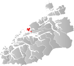
Re-upload of User:Marmelad's Møre og Romsdal map so that it can be used in templates on Møre og Romsdal, Kristiansund, etc.
Map showing the position of Vanylven within Møre og Romsdal, made by Jon Harald Søby.
Map showing the position of Kristiansund within Møre og Romsdal, made by Jon Harald Søby.
Map showing the position of Herøy, Møre og Romsdal within Møre og Romsdal, made by Jon Harald Søby.
Map showing the position of Ørsta within Møre og Romsdal, made by Jon Harald Søby.
Map showing the position of Sula, Norway within Møre og Romsdal, made by Jon Harald Søby.
Autor/Urheber: Jay1279, Lizenz: CC0
Map of Haram Municipality in Møre og Romsdal county, Norway
Map showing the position of Sykkylven within Møre og Romsdal, made by Jon Harald Søby.
Autor/Urheber: Jay1279, Lizenz: CC0
Map of Hustadvika municipality in Møre og Romsdal county, Norway (est. 2020)
Map showing the position of Sande, Møre og Romsdal within Møre og Romsdal, made by Jon Harald Søby.
Map showing the position of Giske within Møre og Romsdal, made by Jon Harald Søby.
Map showing the position of Gjemnes within Møre og Romsdal, made by Jon Harald Søby.
(c) Karte: NordNordWest, Lizenz: Creative Commons by-sa-3.0 de
Positionskarte von Møre og Romsdal, Norwegen
Map showing the position of Stranda within Møre og Romsdal, made by Jon Harald Søby.
Autor/Urheber: Jay1279, Lizenz: CC0
Map of Ålesund Municipality in Møre og Romsdal county, Norway
Map showing the position of Hareid within Møre og Romsdal, made by Jon Harald Søby.
Map showing the position of Surnadal within Møre og Romsdal, made by Jon Harald Søby.
Map showing the position of Sunndal within Møre og Romsdal, made by Jon Harald Søby.
Map showing the position of Rauma, Norway within Møre og Romsdal, made by Jon Harald Søby.
Map showing the position of Aukra within Møre og Romsdal, made by Jon Harald Søby.
Map showing the position of Ulstein within Møre og Romsdal, made by Jon Harald Søby.


