Prinzregent-Luitpold-Land
| Prinzregent-Luitpold-Land Luitpold Coast, costa Confín | ||
|---|---|---|
 Landsat-8-Aufnahme der Luitpold-Küste | ||
| Lage | Coatsland, Ostantarktika | |
| Gewässer | Weddellmeer | |
| Von | Hayes-Gletscher 76° 16′ 0,1″ S, 27° 54′ 0″ W | |
| Bis | Übergang Vahselbucht – Filchner-Schelfeis 78° 15′ 0″ S, 36° 0′ 0″ W | |
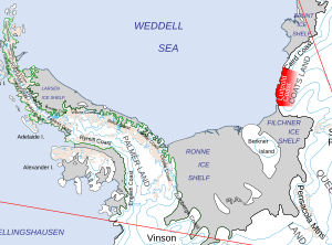
 Kartenskizze mit Luitpold Coast | ||
Koordinaten: 77° 30′ S, 32° 0′ W
Das Prinzregent-Luitpold-Land (auch bekannt als Luitpold-Küste, in Argentinien Costa Confín[1]) erstreckt sich von 77° bis 78°15′ südlicher Breite und von 27°54′, bis 36° westliche Länge an der Küste des Weddell-Meeres und bildet den südwestlichen Teil von Coatsland. (Süd-)Westlich des Prinzregent-Luitpold-Landes liegt Queen Elizabeth Land. Im Osten schließt sich die Caird-Küste an. Entdeckt wurde es von Wilhelm Filchner, dem Leiter der Zweiten Deutschen Antarktisexpedition von 1911/12, und ist nach Prinzregent Luitpold von Bayern (1821–1912) benannt. Argentinische Wissenschaftler benannten den Küstenabschnitt nach seiner Lage, da er die östliche Begrenzung des Weddel-Meeres darstellt (spanisch confín ‚Grenze, Ende‘).[2]
Das Prinzregent-Luitpold-Land ist mit Ausnahme von drei kleinen Nunatakgruppen (Littlewood-, Bertrab- und Moltke-Nunataks) vollständig eisbedeckt.
Literatur
- Georg Kleinschmidt: Geology of nunataks of Prinzregent-Luitpold-Land (Coats Land, Antarctica) and their geotectonic importance. In: Courier Forschungs-Institut Senckenberg. Band 237, 2002, S. 1–14.
Weblinks
- Antarctic Gazetteer, Australian Antarctic Division abgerufen am 30. November 2009
- Luitpold Coast. In: Geographic Names Information System. United States Geological Survey, United States Department of the Interior, archiviert vom (englisch).
Einzelnachweise
- ↑ Confín, costa im Composite Gazetteer of Antarctica, abgerufen am 19. August 2021 (englisch).
- ↑ John Stewart: Antarctica – An Encyclopedia. Bd. 2, McFarland & Co., Jefferson und London 2011, ISBN 978-0-7864-3590-6, S. 956 (englisch).
Auf dieser Seite verwendete Medien
Autor/Urheber: Alexrk2, Lizenz: CC BY-SA 3.0
Physische Positionskarte Antarktis, Mittabstandstreue Azimutalprojektion
Autor/Urheber: O.V.E.R.V.I.E.W., Lizenz: CC BY 2.0
Observational Data courtesy of Landsat 8 satellite (Bands: 2, 3, 4, 8) & USGS. Data processed by Paul Quast.
Data Specifications: Coordinates: -76.9645, -31.2986. Acquired: 9-Dec-2016 (Entity ID: LC81841152016344LGN00, Path: 184, Row: 115).
Features of interest:
Guano Stained Ice (from Penguin Colony) [Middle].Location of the Luitpold Coast of Coats Land, in the British Antarctic Territory


