London Borough of Sutton
| London Borough of Sutton | |
|---|---|
 | |
| Status | London Borough |
| Region | Greater London |
| Verwaltungssitz | Sutton |
| Fläche | 43,85 km² |
| Einwohner | 204.525 |
| Bevölkerungsdichte | 4.664 Einwohner/km² |
| Stand | 30. Juni 2018[1] |
| ONS-Code | 00BF |
| Website | www.sutton.gov.uk |
Der London Borough of Sutton [] ist ein Stadtbezirk von London. Er liegt im Süden der Stadt. Bei der Gründung der Verwaltungsregion Greater London im Jahr 1965 entstand er aus dem Municipal Borough of Sutton and Cheam, dem Municipal Borough of Beddington and Wallington und dem Carshalton Urban District in der Grafschaft Surrey.
Stadtteile
- Beddington
- Beddington Corner
- Belmont[2]
- Benhilton
- Carshalton
- Carshalton Beeches
- Carshalton on the Hill
- Cheam
- Hackbridge
- North Cheam
- Rosehill
- St. Helier
- Sutton
- The Wrythe
- Wallington
- Worcester Park
 Leonie Bridge im Grove Park
 Grove Park
 Oaks Park
 Mayfield Lavendel Felder
 Manor Park
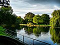 (c) scott brawn, CC BY-SA 2.0Beddington Park
 (c) Wilf Jones, CC BY-SA 2.0Butter Hill
Persönlichkeiten
- Martin Adams (* 1956), Dartspieler
- Harry Aikines-Aryeetey (* 1988), Leichtathlet
- Keith Ballisat (1928–1996), Autorennfahrer
- Jeff Beck (1944–2023), Gitarrist
- Aggie Beever-Jones (* 2003), Fußballspielerin
- Johnny Borrell (* 1980), Sänger
- Quentin Crisp (1908–1999), Dandy, Exzentriker und Schwulenikone
- Jack Draper (* 2001), Tennisspieler
- Paul Greengrass (* 1955), Regisseur und Autor
- David Hunt (1960–2015), Rennfahrer
- Ronald Jenkins (1907–1975), Ingenieur
- Phyllis King (1905–2006), Tennisspielerin
- Peter Ladefoged (1925–2006), Phonetiker
- Peter Manley (* 1962), Dartspieler
- Robbie McIntosh (* 1957), Rockgitarrist
- Rebecca Romero (* 1980), Radsportlerin
- Erick Rowsell (* 1990), Radsportler
- Joanna Rowsell (* 1988), Radsportlerin
- Andrew Stunell (1942–2024), Politiker
- David Wood (* 1944), Schauspieler, Autor und Theaterregisseur
- Ruth Wynne-Davies (1926–2012), Orthopädin
Städtepartnerschaften
Minden und der Berliner Bezirk Charlottenburg-Wilmersdorf sind Partnerstädte.
Weblinks
Commons: London Borough of Sutton – Sammlung von Bildern, Videos und Audiodateien
- Sutton Borough Council (Bezirksverwaltung)
Einzelnachweise und Anmerkungen
- ↑ Mid 2018 Estimates of the population for the UK, England and Wales, Scotland and Northern Ireland
- ↑ Zu „Belmont“ gibt es noch keinen eigenen Artikel, nur eine Weiterleitung zum Lemma „London Borough of Sutton“.
Koordinaten: 51° 22′ N, 0° 12′ W
Auf dieser Seite verwendete Medien

Oaks Park, London Borough of Sutton, colourful trees.jpg
Autor/Urheber: Maureen Barlin from Richmond, UK, Lizenz: CC BY-SA 2.0
24. The London Loop Section 6 Coulsdon South to Banstead Downs 7km
Autor/Urheber: Maureen Barlin from Richmond, UK, Lizenz: CC BY-SA 2.0
24. The London Loop Section 6 Coulsdon South to Banstead Downs 7km

Boating lake, Beddington Park - geograph.org.uk - 1212630.jpg
(c) scott brawn, CC BY-SA 2.0
Boating lake, Beddington Park Boating lake, Beddington Park in September 2006
(c) scott brawn, CC BY-SA 2.0
Boating lake, Beddington Park Boating lake, Beddington Park in September 2006
.jpg)
Leoni Bridge, Carshalton (South Face - 02).jpg
Autor/Urheber: Massimo Usai from London, England, Lizenz: CC BY 2.0
Carshalton
Autor/Urheber: Massimo Usai from London, England, Lizenz: CC BY 2.0
Carshalton

Snow in Manor Park Sutton.jpg
Autor/Urheber: Kemal ATLI, Lizenz: CC BY-SA 2.0
Snow in Manor Park Sutton
Autor/Urheber: Kemal ATLI, Lizenz: CC BY-SA 2.0
Snow in Manor Park Sutton

Waterfall London Borough of Sutton.jpg
Autor/Urheber: Sarah Fraser, Lizenz: CC BY-SA 2.0
Another attempt same day with new ND filter, same place but different POV. I think in this shot the focus on the rocks perhaps improves the look?
Autor/Urheber: Sarah Fraser, Lizenz: CC BY-SA 2.0
Another attempt same day with new ND filter, same place but different POV. I think in this shot the focus on the rocks perhaps improves the look?

Mayfield Lavender Field LB Sutton.jpg
Autor/Urheber: Kemal ATLI, Lizenz: CC BY-SA 2.0
Lavender Field
Autor/Urheber: Kemal ATLI, Lizenz: CC BY-SA 2.0
Lavender Field
Sutton in Greater London.svg
Autor/Urheber: TUBS
 ,
Lizenz: CC BY-SA 3.0
,
Lizenz: CC BY-SA 3.0
Lage des Stadtviertels XY (siehe Dateiname) in Greater London.
Autor/Urheber: TUBS
Lage des Stadtviertels XY (siehe Dateiname) in Greater London.

The fountain at Butter Hill - geograph.org.uk - 362488.jpg
(c) Wilf Jones, CC BY-SA 2.0
The fountain at Butter Hill
(c) Wilf Jones, CC BY-SA 2.0
The fountain at Butter Hill