Lock and Dam No. 11
| Lock and Dam No. 11 | |
|---|---|
 | |
| Wehr | |
| Art: | Segmentwehr Walzenwehr |
| Maximale Stauhöhe: | 2,70 m |
| Dammlänge (beweglicher Teil): | 450,50 m |
| Schleuse | |
| nutzbare Länge: | 182,90 m |
| nutzbare Breite: | 33,50 m |
| Lock and Dam No. 11 Historic District | |||
|---|---|---|---|
| National Register of Historic Places | |||
| Historic District | |||
| |||
| Lage | Dubuque, Iowa Grant County, Wisconsin | ||
| Koordinaten | 42° 32′ 25″ N, 90° 38′ 39″ W | ||
| Fläche | 46,22 ha | ||
| Erbaut | 1934–1937 | ||
| Architekt | Edwin E. Abbott W. A. Turner | ||
| NRHP-Nummer | 04000171 | ||
| Ins NRHP aufgenommen | 2004 | ||
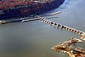
Lock and Dam No. 11 (Schleuse und Staustufe Nr. 11) ist eines von 29 Stauwerken, die die Schifffahrt am oberen Mississippi ermöglichen. Das zwischen 1934 und 1937 vom United States Army Corps of Engineers errichtete kombinierte Bauwerk befindet sich zwischen Dubuque in Iowa und dem Grant County in Wisconsin. Im Jahr 2004 wurde das Lock and Dam No. 11 Historic District in das NRHP aufgenommen.[1]
Staustufe
Zur Staustufe gehören ein 1018 m langer Steindamm auf der Wisconsin-Seite und ein 450,5 m langer regelbarer Teil, der aus einem 13-teiligen Segmentwehr und drei Stauwalzen besteht.
Die Stauhöhe beträgt neun Fuß (2,70 m). Der Zweck des Wehres ist nicht in erster Linie der Hochwasserschutz, sondern das Aufstauen des Mississippi für die Schifffahrt.
Schleuse
Die Schleuse ist 182,9 m lang und 33,5 m breit. Daneben befindet sich eine zweite, jedoch nicht fertiggestellte kleinere Schleusenkammer.
Bilder
 Blick von Wisconsin zum Iowa-Ufer
 Blick von der Schleuse Dubuque über das Wehr nach Wisconsin
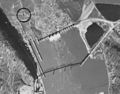 Luftbild von 1940 mit der ehemaligen Eagle Point Bridge
Einzelnachweise
- ↑ Auszug aus dem National Register of Historic Places - Nr. 04000171 Abgerufen am 19. Juli 2012
Weblinks
Auf dieser Seite verwendete Medien

Autor/Urheber: Dirk Hansen, Lizenz: CC BY-SA 3.0
View of Lock and Dam No. 11 as seen from Eagle Point Park in Dubuque, Iowa

Aerial view of Lock and Dam No. 11 on the Mississippi River at Dubuque, Iowa.
- The official name is General Zebulon Pike Lock and Dam.
(c) FluffyGryphon in der Wikipedia auf Englisch, CC BY 2.5
Description: This is Lock and Dam 11 as seen from Eagle Point Park in Dubuque Iowa - Source: I took this photo - Date: Jun 28, 2006 - Author: Daniel Callahan

Mississippi River Lock and Dam No. 11, with the Eagle Point Bridge, near Dubuque in Dubuque County, Iowa and Grant County, Wisconsin.
- Photograph Agency Source Information
- Agency : USDA
- Subject : Water Roll-Exp : 11A-73
- 11/17/1940
- The source agencies responsible for the original flights are the United States Department of Agriculture (USDA) and the United States Geological Survey (USGS). The vast majority of the state was flown by the USDA. Only parts of Forest, Florence, Iron, Marinette, Oneida, and Vilas counties were flown by the USGS.
Photograph Information:
- Format: The original aerial photographs are black and white. They measure either (a)seven inches by nine inches (7”x9”) or (b) nine inches by nine inches (9”x9”).
- Scale: All photographs in the 1937-41 series are 1:20,000 or 1”=1667’
- Copyright: As works of the United States government, all photographs in this collection are in the public domain.

Autor/Urheber: Alexrk2, Lizenz: CC BY 3.0
Diese Landkarte wurde mit GeoTools erstellt.