Local Government Areas im Northern Territory
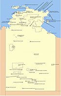
Im australischen Bundesterritorium Northern Territory trat am 1. Juli 2008 eine Neuordnung der Gebietsgliederung in Kraft. Danach gibt es nur noch 17 Local Government Areas (LGAs), davon 5 Municipalities und 11 Shires. Daneben gibt es fünf meist verstreute Unincorporated Areas (etwa gemeindefreie Gebiete), die zu keiner LGA gehören, die jedoch nur noch 1,45 Prozent der Gesamtfläche (19.428 km²) mit vier Prozent der Bevölkerung auf sich vereinigen.
Gliederung seit Juli 2008

Municipalities
- City of Darwin
- City of Palmerston
- Alice Springs Town
- Town of Katherine
- Litchfield Municipality
Shires und Regions
- Barkly Region
- Belyuen Shire
- Central Desert Region
- Coomalie Shire
- East Arnhem Region
- MacDonnell Region
- Roper Gulf Region
- Tiwi Islands Region
- Victoria Daly Region
- Wagait Shire
- West Arnhem Region
Unincorporated Areas
- Alyangula (2,10 km²)
- Darwin Rates Act Area (East Arm) (52,15 km²)
- Nhulunbuy (7,12 km²)
- Unincorporated Top End Region (Finnis-Mary) (19.263,22 km²)
- Yulara (103,33 km², pop. 986)
Frühere Gliederung
Das Northern Territory war bis zum 30. Juni 2008 in 63 lokale Verwaltungsgebiete (Local Government Areas) unterteilt.
Es gab vier Klassifikationen von LGA im Northern Territory
- Municipalities (M.) (6)
- Community Government Council (C.G.C.) (30)
- Incorporated Associations (Inc.) (26)
- Special Purpose Town (S.P.T.) (1)
Daneben gab es das Unincorporated Northern Territory, eine zusammenhängende Fläche, die 92 Prozent des Territoriums (1.237.999 von 1.349.310 km²) mit 16 Prozent der Bevölkerung (30.523 von 192.898)[1][2] einnahm und in dem die LGAs sozusagen als Enklaven lagen.
A
| B
| C
|
D
| E
| G
|
I
| J
| K
|
L
| M
| N
|
P
| R
| T
|
U
| W
| Y
|
Weblinks
- Überblick aller Councils im Northern Territory (englisch)
- Northern Territory Government, Department of Planning and Infrastructure: Northern Territory Local Government Areas - 1st July 2008, Dezember 2004 (PDF; 10,0 MB)
Einzelnachweise
- ↑ Unincorporated NT. 2006 Census Quickstat. Australian Bureau of Statistics, 25. Oktober 2007, abgerufen am 1. Mai 2020 (englisch).
- ↑ Northern Territory. 2006 Census Quickstat. Australian Bureau of Statistics, 25. Oktober 2007, abgerufen am 1. Mai 2020 (englisch).
Auf dieser Seite verwendete Medien
Flag of Australia, when congruence with this colour chart is required (i.e. when a "less bright" version is needed).
See Flag of Australia.svg for main file information.(c) Piano01 in der Wikipedia auf Englisch, CC BY-SA 3.0
Entirely my own work for the Local Government Areas in the Northern Territory
Autor/Urheber:
- Australia_Northern_Territory_location_map.svg: NordNordWest
- derivative work: Cassowary (talk)
Location map of the Northern Territory, Australia


