Livingston-Insel
| Livingston-Insel | ||
|---|---|---|
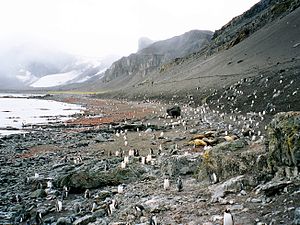
| Der Liverpool Beach an der Südküste der Livingston-Insel | ||
| Gewässer | Südlicher Ozean (zwischen Drake- und Bransfieldstraße) | |
| Inselgruppe | Südliche Shetlandinseln | |
| Geographische Lage | 62° 36′ S, 60° 30′ W | |
| Länge | 73 km | |
| Breite | 35 km | |
| Fläche | 974 km² | |
| Höchste Erhebung | Mount Friesland 1700 m | |
| Karte der Livingston-Insel | ||
Die Livingston-Insel (englisch Livingston Island) ist die zweitgrößte Insel der Südlichen Shetlandinseln vor der Westantarktis.
Die Insel ist 73 km lang und 34 km breit, die Fläche beträgt 974 km². Sie liegt westlich der benachbarten Greenwich Island sowie nördlich der Deception-Insel. Der höchste Punkt Livingstons ist mit 1700 Metern der Berggipfel Mount Friesland in den Tangra Mountains. Die Temperaturen im Sommer überschreiten kaum 3 °C, im Winter kann es bis −14 °C kalt werden.
Die Insel wurde am 19. Februar 1819 vom englischen Seefahrer William Smith entdeckt und bereits kurz darauf von Robbenjägern aufgesucht.
Heute befinden sich auf Livingston einige antarktische Forschungsstationen, darunter die spanische Juan-Carlos-I.-Station und die bulgarische St.-Kliment-Ohridski-Station. Die Insel ist auch Station für den Besuch von Kreuzfahrtschiffen.
Nach dem deutschen Politiker Manfred Wörner wurde der hier vorhandene Bergsattel Wörner Gap benannt.
Karten
- L. L. Ivanov: Antarctica: Livingston Island and Greenwich, Robert, Snow and Smith Islands. Topografische Karte im Maßstab 1:120.000. Manfred-Wörner-Stiftung, Troyan, 2009, ISBN 978-954-92032-6-4
- L. L. Ivanov. Antarctica: Livingston Island and Smith Island. Scale 1:100000 topographic map. Manfred Wörner Foundation, 2017. ISBN 978-619-90008-3-0
Weblinks
- Ivanov, L. General Geography and History of Livingston Island. In: Bulgarian Antarctic Research: A Synthesis. Eds. C. Pimpirev and N. Chipev. Sofia: St. Kliment Ohridski University Press, 2015. S. 17–28. ISBN 978-954-07-3939-7
- Gildea, D. Mountaineering in Antarctica: complete guide: Travel guide. Primento and Editions Nevicata, 2015. ISBN 978-2-51103-136-0
- Ivanov, L.L. Livingston Island: Tangra Mountains, Komini Peak, west slope new rock route; Lyaskovets Peak, first ascent; Zograf Peak, first ascent; Vidin Heights, Melnik Peak, Melnik Ridge, first ascent. The American Alpine Journal, 2005. S. 312–315.
Auf dieser Seite verwendete Medien
Autor/Urheber: Apcbg, Lizenz: CC BY-SA 4.0
L.L. Ivanov. Antarctica: Livingston Island and Smith Island. Scale 1:100000 topographic map. Manfred Wörner Foundation, 2017. ISBN 978-619-90008-3-0
Autor/Urheber: Lyubomir Ivanov, Lizenz: GPL
Liverpool Beach at Hannah Point on Livingston Island in the South Shetland Islands, one of the most popular tourist sites in Antarctica.
- Viewpoint location: Hannah Point, the northwest side of the entrance to South Bay, Livingston Island in the South Shetland Islands
- Viewpoint elevation: 2 meters
- View direction: north
- Camera: HP PhotoSmart C945 (V01.54)
Autor/Urheber: NordNordWest, Lizenz: CC BY-SA 3.0
Positionskarte der Südlichen Shetlandinseln


