Little America (Antarktis)
Koordinaten: 78° 30′ S, 164° 20′ W

Little America I bis V waren im Zeitraum von 1928 bis 1958 bestehende US-amerikanische Stationen auf dem Ross-Schelfeis im antarktischen Rossmeer. Die erste Station wurde im Rahmen der ersten Antarktisexpedition (1928–1930) des US-amerikanischen Polarforschers Richard Evelyn Byrd errichtet. Weitere entstanden bei Byrds zweiter Expedition (1933–1935), als Westbasis der United States Antarctic Service Expedition (1939–1941), bei der Operation Highjump (1946–1947) und bei der ersten Operation Deep Freeze (1955–1956). Die Forschungsbasen sind Namensgeber für das Little America Basin, ein Seebecken unweit der Bay of Whales.
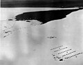
Luftaufnahme der Bucht der Wale mit Little America IV (südlicher Sommer 1946–47)

Little America IV (ca. 1947)
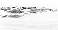
Luftaufnahme von Little America V (1956)
Weblinks
Auf dieser Seite verwendete Medien

View of the rows of tents and other structures that formed the "Little America IV" station in the Antarctic during the U.S. Navy "Operation Highjump".
A map illustrating the locations of Little America I, II, III, and IV

This scanned image of the Little America IV camp is of poor quality due to the condition of the original photo. The camp is in the lower right. Three ships are moored at the ice edge at center left. This expedition was part of the US Navy's Operation Highjump, 1946-1947. Admiral Richard Byrd had established Little America I, II, III, and IV all within this same general area at the Bay of Whales. Ten years later when the US Navy returned to establish Little America V as part of the International Geophysical Year (IGY), they were unable to reach this site due to ice, so built the final Little America station farther east.

Aerial view of Little America V.