Liste von Theokratien
Dies ist eine Liste von Theokratien, besser bekannt als Gottesstaaten.
Literatur
- Mario Ferrero: The Economics of Theocracy. in: Ronald Wintrobe, Mario Ferrero (Hrsg.): The Political Economy of Theocracy. 2009 (Online-Auszug)
Auf dieser Seite verwendete Medien
PapalStates1700.png
Autor/Urheber: Gabagool, Lizenz: CC BY 3.0
Locator map showing the Papal States, with its enclaves, in the year 1700.
(Partially based on Euratlas map of Europe - 1700.)
Autor/Urheber: Gabagool, Lizenz: CC BY 3.0
Locator map showing the Papal States, with its enclaves, in the year 1700.
(Partially based on Euratlas map of Europe - 1700.)
Second world war asia 1937-1942 map en6.png
Autor/Urheber: Original Author: User:San Jose
Derivative Author: Dead Mary, Lizenz: CC-BY-SA-3.0
A map of the Japanese advance from 1937 to 1942.
Autor/Urheber: Original Author: User:San Jose
Derivative Author: Dead Mary, Lizenz: CC-BY-SA-3.0
A map of the Japanese advance from 1937 to 1942.
Vatican City map DE.png
(c) Thomas Römer/OpenStreetMap data, CC BY-SA 3.0
Karte der Vatikanstadt (deutsche Version)
(c) Thomas Römer/OpenStreetMap data, CC BY-SA 3.0
Karte der Vatikanstadt (deutsche Version)
Umayyad750ADloc.png
Autor/Urheber: Gabagool, Lizenz: CC BY 3.0
Locator map for the Umayyad Caliphate at its greatest extent, c. AD 750. (Partially based on Atlas of World History (2007) - World 500-750, map.)
Autor/Urheber: Gabagool, Lizenz: CC BY 3.0
Locator map for the Umayyad Caliphate at its greatest extent, c. AD 750. (Partially based on Atlas of World History (2007) - World 500-750, map.)
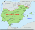
Califato de Córdoba - 1000 de.svg
Autor/Urheber:
Kalifat von Cordoba im Jahr 1000.
Autor/Urheber:
- Califato de Córdoba - 1000.svg: Tyk
- this file: Furfur
Kalifat von Cordoba im Jahr 1000.
Fula jihad states map general c1830.png
I made this, using the commons' en:Image:Africa_map_blank.svg as a template. Shows the major Fula / Fulani /Peul Jihad states of West Africa, circa 1830, prior to the rise of Umar Tall.
I made this, using the commons' en:Image:Africa_map_blank.svg as a template. Shows the major Fula / Fulani /Peul Jihad states of West Africa, circa 1830, prior to the rise of Umar Tall.
Ottoman empire de.svg
Autor/Urheber:
Das Osmanisches Reich von 1481 bis 1683
Autor/Urheber:
- Ottoman_empire.svg: André Koehne
- derivative work: Furfur
Das Osmanisches Reich von 1481 bis 1683
Afghanistan physical map.svg
Autor/Urheber: Urutseg, Lizenz: CC0
Physical map of Afghanistan, parameters are equal to File:Afghanistan location map.svg
Autor/Urheber: Urutseg, Lizenz: CC0
Physical map of Afghanistan, parameters are equal to File:Afghanistan location map.svg
Kingdom of Israel 1020 map-de.svg
Autor/Urheber: Online-today, Lizenz: CC BY-SA 4.0
German translation
Autor/Urheber: Online-today, Lizenz: CC BY-SA 4.0
German translation
Safavid Empire 1501 1722 AD.png
A map depicting the extent the Safavid Empire at its greatest extent under Ismail I.
A map depicting the extent the Safavid Empire at its greatest extent under Ismail I.
Ancestral Puebloan territory.svg
Autor/Urheber: Maproom, Lizenz: CC BY-SA 3.0
Map of the extent of Ancestral Puebloan settlements.
Autor/Urheber: Maproom, Lizenz: CC BY-SA 3.0
Map of the extent of Ancestral Puebloan settlements.
Escalade-battle-2.jpg
L'Escalade à Genève, 1602. Gravure en taille-douce à l'acide.
The Escalade in Geneva in 1602. Etching enhanced with watercolor painting.
L'Escalade à Genève, 1602. Gravure en taille-douce à l'acide.
The Escalade in Geneva in 1602. Etching enhanced with watercolor painting.
Mohammad adil-Rashidun-empire-at-its-peak-close.PNG
(c) Mohammad adil aus der englischsprachigen Wikipedia, CC BY-SA 3.0
Empire of the Rashidun Caliphate at its peak.
(c) Mohammad adil aus der englischsprachigen Wikipedia, CC BY-SA 3.0
Empire of the Rashidun Caliphate at its peak.
Iran in its region.svg
Autor/Urheber: TUBS
 ,
Lizenz: CC BY-SA 3.0
Lage von XY (siehe Dateiname) in der Region.
Autor/Urheber: TUBS
Lage von XY (siehe Dateiname) in der Region.
Senegalvalleystatesc1850.png
The states of the lower Senegal River valley (roughly), circa 1850, before the rise of Umar Tall
The states of the lower Senegal River valley (roughly), circa 1850, before the rise of Umar Tall
Fatimid Islamic Caliphate.png
The Fatimid Caliphate at its greatest extent.
The Fatimid Caliphate at its greatest extent.
Territorial control of the ISIS.svg
Autor/Urheber: NordNordWest, Spesh531, Lizenz: CC BY-SA 3.0
Autor/Urheber: NordNordWest, Spesh531, Lizenz: CC BY-SA 3.0
Vom IS kontrolliertes Gebiet
Vom IS beanspruchtes Gebiet
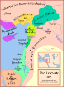
Map Crusader states 1135-de.svg
Autor/Urheber: MapMaster, Lizenz: CC BY-SA 3.0
Die Levante, 1135, zwischen den Ersten und Zweiten Kreuzzügen. Kreuzzugsstaaten sind mit einem roten Kreuz gekennzeichnet
Autor/Urheber: MapMaster, Lizenz: CC BY-SA 3.0
Die Levante, 1135, zwischen den Ersten und Zweiten Kreuzzügen. Kreuzzugsstaaten sind mit einem roten Kreuz gekennzeichnet
Italy 1454 after the Peace of Lodi.jpg
Italien nach dem Frieden von Lodi 1454.
Italien nach dem Frieden von Lodi 1454.
MuensterUnderSiege1534.jpg
The city of Münster under siege by Prince-Bishop Franz von Waldeck in 1534. The picture shows the first attack at Pentecost. The text below the image says: "Ein verzeychnung der Stat Münster mit all irer gelegenheit / mauren / thüren / zinnen / waten / schrankken / pasteyen / unnd geweren / wassergreben. Auch wie die von irem Bischoff am Freytage vor Pfingsten / des M.D. xxxiiii. Jars berennt / (und?) Zibben legern ringhweis .... zu übergeben/und nachmals an Sant Egidien abent an fünff orten an gelauffen/ und hefftig gestürmbt worden. Alda ir seer vil vom Adel sambt andern kriegs volck auff beiden theylen erlegen seind / wie etlich sagen / bey drey tausenden! Gott..."
First century Iudaea province.gif
This is a map of first century Iudaea Province that I created using Illustrator CS2. I traced this image for the general geographic features. I then manually input data from maps found in a couple of sources.
This is a map of first century Iudaea Province that I created using Illustrator CS2. I traced this image for the general geographic features. I then manually input data from maps found in a couple of sources.
- Robert W. Funk and the Jesus Seminar. The Acts of Jesus. HarperSanFrancisco: 1998. p. xxiv.
- Michael Grant. Jesus: An Historian's Review of the Gospels. Charles Scribner's Sons: 1977. p. 65-67.
- John P. Meier. A Marginal Jew. Doubleday: 1991. p. 1:434.
Bhutan relief location map.jpg
Autor/Urheber: NordNordWest, Lizenz: CC BY-SA 3.0 de
Positionskarte von Bhutan
Autor/Urheber: NordNordWest, Lizenz: CC BY-SA 3.0 de
Positionskarte von Bhutan
Sokoto caliphate.png
Autor/Urheber: WikiEditor2004, Lizenz: CC0
Sokoto Caliphate in the 19th century.
Autor/Urheber: WikiEditor2004, Lizenz: CC0
Sokoto Caliphate in the 19th century.
Abbasids Dynasty 750 - 1258 (AD).PNG
(c) Arab League in der Wikipedia auf Englisch, CC BY-SA 3.0
Abbasid Empire 750-788. Note that during the era of the Abbasid caliphate's maximum expansion, Fustat was actually the main city of Egypt...
(c) Arab League in der Wikipedia auf Englisch, CC BY-SA 3.0
Abbasid Empire 750-788. Note that during the era of the Abbasid caliphate's maximum expansion, Fustat was actually the main city of Egypt...
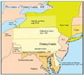
Penncolony.png
Autor/Urheber: Die Autorenschaft wurde nicht in einer maschinell lesbaren Form angegeben. Es wird Kmusser als Autor angenommen (basierend auf den Rechteinhaber-Angaben)., Lizenz: CC BY-SA 2.5
This is a map of the Province of Pennsylvania that I made. Boundary disputes between colonies not involving Pennsylvania are not shown.
Inca Expansion.svg
Autor/Urheber: QQuantum, Lizenz: CC BY-SA 4.0
Map of the expansion of the Inca Empire from 1438 CE to 1533 CE with present-day borders.
Autor/Urheber: QQuantum, Lizenz: CC BY-SA 4.0
Map of the expansion of the Inca Empire from 1438 CE to 1533 CE with present-day borders.
Mamluks1279.png
Autor/Urheber: Gabagool, Lizenz: CC BY 3.0
Map of the Mamluk sultanate of Egypt, AD 1279. (Partially based on [1])
Autor/Urheber: Gabagool, Lizenz: CC BY 3.0
Map of the Mamluk sultanate of Egypt, AD 1279. (Partially based on [1])
Kingdoms of Israel and Judah map 830.svg
Autor/Urheber:
Approximate map showing (blue) and (orange), ancient Southern Levant borders and ancient cities such as Urmomium and Jerash. The map shows the region in the 9th century BCE.
Autor/Urheber:
- Oldtidens_Israel_&_Judea.svg: FinnWikiNo
- derivative work: Richardprins (talk)
Approximate map showing (blue) and (orange), ancient Southern Levant borders and ancient cities such as Urmomium and Jerash. The map shows the region in the 9th century BCE.
Empire almohade.PNG
Autor/Urheber: Omar-Toons, Lizenz: CC BY-SA 3.0
Carte de l'Empire almohade.
Selon: Qantara-Med.org [1] [2]
Autor/Urheber: Omar-Toons, Lizenz: CC BY-SA 3.0
Carte de l'Empire almohade.
Selon: Qantara-Med.org [1] [2]


