Liste von Flüssen in Mosambik

Dies ist eine Liste von Flüssen in Mosambik. In dem langgestreckten Küstenstaat Mosambik in Südost-Afrika münden mehrere große Flüsse. Der größte ist der Sambesi, gefolgt von Limpopo, Save und Rovuma. Zusammen mit dem Lurio machen die Einzugsgebiete dieser Flüsse über die Hälfte des Landes aus. Allerdings hat Mosambik auf Grund seiner Geographie nur einen vergleichsweise geringen Anteil an den Einzugsgebieten der Internationalen Flüsse. Zudem ist das Land im Monsun recht niederschlagsreich mit einer flachen Küste und besitzt daher auch viele Küstenflüsse.
Im Folgenden sind die Flüsse nach Einzugsgebiet (von Nord nach Süd) und alphabetisch sortiert (Auswahl).[1]
Mündungsreihenfolge

- Messinge
- Lucheringo
- Chiulezo
- Lugenda
- Luambala
- Luatize
- Lureco

- Luangwa
- Hunyani
- Angwa
- Umsengedsi
- Luia
- Vuboe
- Muangadeze
- Luangua
- Capoche
- Sadzo
- Mucumbuzi
- Luatize
- Piauanhe
- Mucumbuzi
- Nhimbe
- Cherize
- Revuboe
- Lifidzi
- Maue
- Livirandzi
- Namanzi
- Ponfi
- Condedezi
- Duembe
- Vudzi
- Luenha (Gaerezi)
- Mazowe
- Metangua (Luai)
- Mazowe
- Muira
- Shire
- Ruo
- Pompue
- Chinde
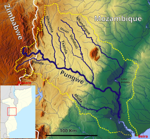
Pungwe (Pungoé)

- Honde
- Nhazonia
- Txatola
- Vunduzi
- Muazi
- Nhandugue
- Muda

- Mwenezi (Manisi)
- Olifants River (Mpumalanga)
- Changane
- Aluize
- Inhabenzule
- Lichangalimue
- Buabuassi
- Chefu
- Chingovo
- Inhabenzule
- Chigombe
- Panzene
- Sangtane
- Chichacarra
- Aluize

Weitere

- Macanga
- Quibanda
- Meronvi
- Calundi
- Messalo
- Montepuez
- Megaruma
- Lurio
- Mecequece
- Lalaua
- Mecubúri
- Monapo
- Muecata
- Mongicual
- Malato
- Metomode
- Meluli
- Ligonha
- Namiroe
- Molocue
- Melela
- Raraga
- Niplodi
- Licungo
- Luo
- Lugera
- Nhamacurra
- Moon
- Namacurra
- Lualua

- Sanga
- Chiniziua
- Sambazo
- Sangussi
- Búzi
- Lucite
- Mussapa
- Revue
- Lucite
- Ucarranga
- Gorongosa
- Repembe
- Inhanjane
- Mocolosse
- Save (Sabi)
- Vumaoze
- Coa
- Govuro
- Inhanhombe
- Guiua
- Mutamba
- Inharrime
Alphabetisch
A
- Angwa
B
- Buabuassi – Búzi
C
- Calundi – Capoche – Changane – Chefu – Cherize – Chichacarra – Chigombe – Chinde – Chingovo – Chiniziua – Chiulezo – Coa – Condedezi
D
- Duembe
G
- Gorongosa – Govuro – Guiua
H
- Honde – Hunyani
I
- Inflene – Inhabenzule – Inhanhombe – Inhanjane – Inharrime – Inkomati
L
- Lalaua – Lichangalimue – Licungo – Lifidzi – Ligonha – Limpopo – Livirandzi – Lualua – Luambala – Luangwa – Luangua – Luatize – Lucheringo – Lucite – Luenha – Lugenda – Lugera – Luia – Luo – Lureco – Lurio
M
- Macanga – Malato – Manisi – Massintonto – Maputo – Matola – Maue – Mazimechopes – Mazowe – Mbuluzi – Mecequece – Mecubúri – Megaruma – Melela – Meluli – Meronvi – Messalo – Messinge – Metangua (Luai) – Metomode – Molocue – Mocolosse – Monapo – Mongicual – Montepuez – Moon – Muangadeze – Muazi – Mucumbuzi – Muda – Muecata – Muira – Mussapa – Mutamba
N
- Namacurra – Namanzi – Namiroe – Nhamacurra – Nhandugue – Nhazonia – Nhimbe – Niplodi – Nwanedzi
O
P
- Panzene – Piauanhe – Pompue – Ponfi – Pungwe
Q
- Quibanda
R
- Raraga – Repembe – Revue – Rovuma – Ruo – Revuboe
S
- Sabie – Sadzo – Sambazo – Sambesi – Sanga – Sangtane – Sangussi – Save – Shingwedzi – Shire
T
- Tembe – Txatola
U
- Ucarranga
V
- Vuboe – Vudzi – Vumaoze – Vunduzi
Einzugsgebietaufteilung des Landes in Prozent
| Einzugsgebiet | Quadratkilometer in Mosambik | Quadratkilometer gesamt | Prozent der Landesfläche[2] |
|---|---|---|---|
| Sambesi | 178.448 | 1.474.004 | 22,3 |
| Rovuma | 100.126 | 154.727 | 12,5 |
| Limpopo | 86.398 | 422.741 | 10,8 |
| Lurio | 61.011 | 61.015 | 7,6 |
| Pungoe | 29.911 | 31.366 | 3,7 |
| Buzi | 26.005 | 29.790 | 3,2 |
| Messalo | 24.456 | 24.456 | 3,1 |
| Licungo | 22.761 | 22.761 | 2,8 |
| Save | 16.845 | 103.076 | 2,1 |
| Incomati | 14.998 | 46.649 | 1,9 |
| Ligonha | 14.737 | 14.737 | 1,8 |
| Inharrime | 13.478 | 13.478 | 1,7 |
| Govuro | 11.289 | 11.289 | 1,4 |
| Meluli | 10.253 | 10.253 | 1,3 |
| Gorongose | 10.212 | 10.212 | 1,3 |
| Montepuez | 10.040 | 10.040 | 1,3 |
| Mucuburi | 9439 | 9439 | 1,2 |
| Raraga | 9123 | 9123 | 1,1 |
| Melela | 8180 | 8180 | 1,0 |
| Monapo | 8006 | 8006 | 1,0 |
| Namacurra | 7563 | 7563 | 0,9 |
| Molocue | 6512 | 6512 | 0,8 |
| Megaruma | 5446 | 5446 | 0,7 |
| Mongicual | 3254 | 3254 | 0,4 |
| Ucarranga | 3016 | 3016 | 0,4 |
| Calundi | 2619 | 2619 | 0,3 |
| Umbeluzi | 2319 | 5589 | 0,3 |
| Maputo | 1979 | 30.903 | 0,2 |
| Einzugsgebiete kleiner 2000 km² | 103.166 | 12,9 | |
| Mosambik gesamt | 801.590 | 100,0 |
Weblinks
Einzelnachweise
- ↑ U.S. Militärkarten bei loadmap.net
- ↑ Development of Master Plan for Water Resourses Management in Mozambique. Abgerufen am 4. Dezember 2020 (englisch).
Auf dieser Seite verwendete Medien
Autor/Urheber: Hans Braxmeier & Peter in s, Lizenz: CC BY-SA 2.0
Die Flüsse und ihre Einzugsgebiete in Eswatini
Autor/Urheber: Keenan Pepper, Peter in s, Location map:NordNordWest, Lizenz: CC BY-SA 4.0
Modification of Limpopo River basin map.svg, Based up on US Army map SG35-36, SF35-36
Autor/Urheber: Hans Braxmeier & Peter in s, Location map:Sting, Lizenz: CC BY-SA 3.0
Map of the Ruvuma River drainage basin_OSM. Based on US military map sd37
Autor/Urheber: Hans Braxmeier & Peter in s, Location map:NordNordWest, Lizenz: CC BY-SA 3.0
The Pungwe basin OSM, Based up on US Army map SE36
Autor/Urheber: Hans Braxmeier & Peter in s, Location map:NordNordWest, Lizenz: CC BY-SA 3.0
Rivers of south Mozambique_OSM. Based on US military map se36, sf36, sg36
Autor/Urheber: Hans Braxmeier & Peter in s, Location map:NordNordWest, Lizenz: CC BY-SA 3.0
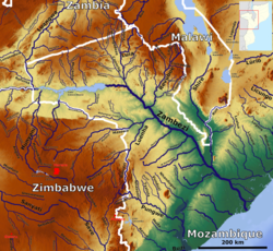
Lower_Zambezi_OSM. Based on US military map se36-37, sd36-37
Autor/Urheber: Hans Braxmeier & Peter in s, Location map:NordNordWest, Lizenz: CC BY-SA 3.0
Rivers of the northern Mozambique_OSM. Based on US military map sd37


