Liste der Ramsar-Gebiete in Niger
Die Liste der Ramsar-Gebiete in Niger umfasst die 14 nach der Ramsar-Konvention geschützten Feuchtgebiete in Niger, die eine Gesamtfläche von 7.534.289 Hektar aufweisen (Stand: 3. Januar 2022).[1]
Liste
| Foto | Name | Region | Fläche in ha | Ausweisungsdatum | Nummer | Lagekarte | |
|---|---|---|---|---|---|---|---|
 | Nationalpark W | Tillabéri | 385.000 | 30.04.1987 | 355 | ||
| Kokorou-Namga-Komplex | Tillabéri | 66.829 | 17.06.2001 | 1071 | |||
 | Tschadsee | Diffa | 338.550 | 17.06.2001 | 1072 | ||
| Feuchtgebiet am mittleren Niger | Dosso | 52.180 | 17.06.2001 | 1073 | |||
| Dallol Maouri | Dosso | 317.520 | 26.04.2004 | 1381 | |||
 | Dallol Bosso | Dosso | 892.122 | 26.04.2004 | 1382 | ||
 | Feuchtgebiet am mittleren Niger II | Dosso | 38.555 | 26.04.2004 | 1383 | ||
| Mare de Dan Doutchi | Tahoua | 38.250 | 16.09.2005 | 1492 | |||
| Mare de Lassouri | Zinder | 34.000 | 16.09.2005 | 1493 | |||
 | Mare de Tabalak | Tahoua | 107.100 | 16.09.2005 | 1494 | ||
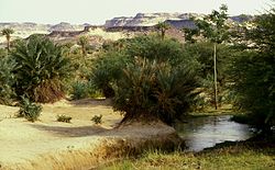
| Oasen des Kawar | Agadez | 339.220 | 16.09.2005 | 1495 | |||
 | Gueltas und Oasen des Aïr | Agadez | 4.924.100 | 16.09.2005 | 1501 | ||
| Guidimouni-See | Zinder | 338 | 18.12.2019 | 2450 | |||
 | Madarounfa-See | Maradi | 524 | 18.12.2019 | 2451 |
Einzelnachweise
- ↑ Niger. List. In: Ramsar Sites Information Service. Abgerufen am 3. Januar 2023 (englisch).
Auf dieser Seite verwendete Medien
(c) OOjs UI Team and other contributors, MIT
An icon from the OOjs UI MediaWiki lib.
Autor/Urheber: Roland Hunziker https://www.flickr.com/photos/rolandh/, Lizenz: CC BY-SA 2.0
A partially dry steam in the W National Park, Niger. Note, the photgraph was taken at the end of March, in the midst of the driest -- and hottest -- months of the year. The stream seen here could well be a good sized river at other times.
Autor/Urheber: Angeline A. van Achterberg , Lizenz: CC BY-SA 4.0
A temporary lake with reeds, trees in the water and a heron and other birds at Tabalak.
Autor/Urheber: NigerTZai, Lizenz: CC BY-SA 4.0
View from the western part of the town of Filingué (in Niger) over the Dallol Bosso valley towards the escarpment.
Autor/Urheber: Jacques Taberlet, Lizenz: CC BY 3.0
At the bivouac in the Arakao, Massif de l'Aïr
Autor/Urheber: Martin23230, Lizenz: CC BY-SA 3.0
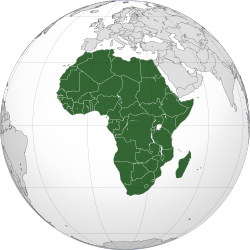
Orthographic map of Africa
Autor/Urheber: YoTuT from United States, Lizenz: CC BY 2.0
The border crossing into Benin from Niger
(c) Holger Reineccius, CC BY-SA 3.0
Palmengärten in der Oase Bilma, Kaouar-Tal in Niger
Lake Chad
Autor/Urheber: Barke11, Lizenz: CC BY-SA 4.0
Une vue du lac de Madarounfa avec des troupeaux de passage
Autor/Urheber: Carport, Lizenz: CC BY-SA 2.0
Physische Positionskarte von Niger


