Liste der Ramsar-Gebiete in Namibia
Lage der Ramsar-Gebiete in Namibia |
Ramsar-Gebiete in Namibia sind nach der 1971 geschlossenen Ramsar-Konvention geschützte Feuchtgebiete in Namibia. Diese sind von internationaler Bedeutung, nach der Absicht des internationalen völkerrechtlichen Vertrags insbesondere als Lebensraum für Wasser- und Watvögel.
Namibia weist zurzeit fünf Ramsar-Gebiete mit einer Fläche von 676.564 Hektar (ha) aus (Stand 2023).
Liste der Ramsar-Gebiete
(TRS) = grenzüberschreitend
| Name des Gebiets | Bild | Lage | Koordinaten | Größe in ha | Höhe in m ü.NHN | Ausweisungs- Datum | Anzahl Vögel |
|---|---|---|---|---|---|---|---|
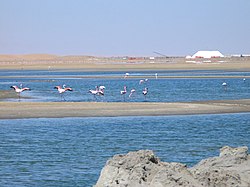
| Walvis-Bay-Feuchtgebiet |  | Walvis Bay, Erongo | 22° 58′ 32″ S, 14° 27′ 18,5″ O | 12.600 | Meereshöhe | 19. Juni 1995 | 70.000–240.000 |
| Sandwich Harbour |  | südlich von Walvis Bay, Erongo | 23° 9′ 55″ S, 14° 27′ 10,3″ O | 16.500 | Meereshöhe | 19. Juni 1995 | 75.000–400.000 |
| Oranje-Mündung (TRS) |  | ǁKaras | 28° 35′ 52,7″ S, 16° 27′ 16,2″ O | 500 | Meereshöhe | 19. Juni 1995 | |
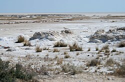
| Etosha-Pfanne, Cuvelai, Oponono-See |  | Nordzentralnamibia | 18° 45′ 39,2″ S, 16° 20′ 20,6″ O 18° 9′ 0″ S, 15° 47′ 0″ O | 600.000 | 1200 | 19. Juni 1995 | |
| Lower Okavango-Bwabwata[1][2] |  | Bwabwata-Nationalpark | 17° 57′ 54,6″ S, 22° 25′ 46,4″ O | 46.964 | 13. Dezember 2013 |
Siehe auch
Weblinks
- Ramsar-Gebiete in Namibia (offizielle Seite) (englisch)
Einzelnachweise
- ↑ Nam shows commitment to Ramsar Convention The Namibian, 22. Januar 2014, S. 7
- ↑ Namibia has designated its fifth Ramsar Site, Bwabwata - Okavango. Namibia Nature Foundation, 21. Januar 2014 ( vom 26. Januar 2014 im Internet Archive) abgerufen am 24. Januar 2014
- ↑ Annotated List of Wetlands of International Importance: Namibia. (PDF; 112 KB) In: rsis.ramsar.org. Abgerufen am 1. Mai 2023 (englisch).
- ↑ Mary Seely, John Pallett: Namib - Secrets of a desert uncovered. Venture Publications, Windhoek 2008, ISBN 978-3-941602-06-9, S. 44.
Auf dieser Seite verwendete Medien
Autor/Urheber: Martin23230, Lizenz: CC BY-SA 3.0
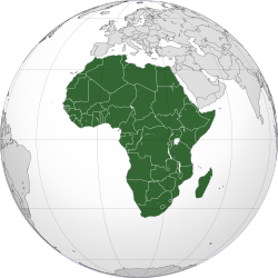
Orthographic map of Africa
(c) Uwe Dedering in der Wikipedia auf Deutsch, CC BY-SA 3.0
Location map of Namibia
Equirectangular projection. Strechted by 108.0%. Geographic limits of the map:
- N: -16.4° N
- S: -29.6° N
- W: 11.0° E
- E: 25.8° E
Autor/Urheber: Harald Süpfle, Lizenz: CC BY-SA 2.5
Flamingos, Saline, Walvisbay, Namibia
Autor/Urheber: yakovlev.alexey from Moscow, Russia, Lizenz: CC BY-SA 2.0
Orange River mouth, Alexander Bay, Northern Cape, South Africa
village in the eastern caprivi floodplains taken during the filming of 'flying the falls' - http://www.flyingthefalls.com
Autor/Urheber: Lidine Mia, Lizenz: CC BY-SA 4.0
Dunes coincées entre l'Océan (lagune de Walvis Bay) et le désert du Namib.
Autor/Urheber: Moongateclimber, Lizenz: CC BY 3.0
The Etosha Pan, in Etosha National Park, Namibia


