Liste der Orte in der Gemeinde Dili

Die Gemeinden Dili und Atauro in Osttimor

Die Liste der Orte in der Gemeinde Dili gibt an, welche Ortschaften in jedem Suco der osttimoresischen Gemeinde Dili liegen und welche geographische Koordinaten und Meereshöhe sie haben. Als Orte sind hier auch die Ortsteile der Stadt Dili aufgeführt, da verwaltungstechnisch in Osttimor dabei nicht von eigenständigen Siedlungen unterschieden wird. 2022 wurde die Insel Atauro als eigenständige Gemeinde abgetrennt.

Die Änderungen von 2015 und 2017 wurden noch nicht in dieser Liste berücksichtigt.

Landkarten

Liste

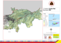
Das Verwaltungsamt Cristo Rei

Verwaltungsamt Cristo Rei
Cristo Rei
Suco Balibar
OrtePositionHöheOrtePositionHöhe
Balibar8° 36′ 0″ S, 125° 35′ 42″ O642 mFatu Loda8° 35′ 59″ S, 125° 35′ 29″ O642 m
Lacoto8° 35′ 52″ S, 125° 35′ 9″ O651 mTancae8° 35′ 50″ S, 125° 36′ 3″ O625 m
Suco Becora
OrtePositionHöheOrtePositionHöhe
Becusi Leten8° 33′ 51″ S, 125° 36′ 17″ O[1]264 mCulau8° 34′ 19″ S, 125° 36′ 18″ O307 m
Darlau8° 35′ 42″ S, 125° 37′ 56″ O536 mLebuhua8° 36′ 25″ S, 125° 37′ 37″ O865 m
Maliqueo8° 35′ 1″ S, 125° 36′ 17″ O402 mMasau Leten8° 33′ 42″ S, 125° 36′ 27″ O265 m
Masau8° 33′ 25″ S, 125° 35′ 52″ O166 mMota Ulun8° 34′ 22″ S, 125° 36′ 52″ O350 m
Suco Bidau Santana
OrtePositionHöheOrtePositionHöhe
Masau8° 33′ 22″ S, 125° 36′ 3″ O166 mMota Claran8° 33′ 9″ S, 125° 35′ 44″ O43 m
Santana8° 32′ 56″ S, 125° 35′ 35″ O43 m
Suco Camea
OrtePositionHöheOrtePositionHöhe
Aidac Bihare8° 34′ 20″ S, 125° 37′ 36″ O373 mAilele Hun8° 33′ 21″ S, 125° 37′ 25″ O
Ailoc Laran8° 34′ 13″ S, 125° 37′ 42″ O304 mBedois8° 33′ 50″ S, 125° 37′ 31″ O313 m
Benamauc8° 34′ 7″ S, 125° 37′ 3″ O[1]?Buburlau8° 34′ 15″ S, 125° 37′ 11″ O304 m
Cadabunac8° 35′ 7″ S, 125° 37′ 53″ OFatuahi8° 34′ 3″ S, 125° 38′ 4″ O272 m
Karomate8° 34′ 27″ S, 125° 37′ 3″ O350 mLekuru Laun8° 35′ 4″ S, 125° 38′ 17″ O
Lenuc Hun8° 33′ 4″ S, 125° 36′ 50″ OSusan8° 34′ 10″ S, 125° 38′ 21″ O233 m
Suco Culu Hun
OrtePositionHöheOrtePositionHöhe
Becusi de Baixo8° 33′ 44″ S, 125° 35′ 45″ O166 mKuluhum de Cima8° 33′ 22″ S, 125° 35′ 36″ O84 m
Kuluhum Taibesi Leten8° 33′ 41″ S, 125° 35′ 36″ O84 m
Suco Hera
OrtePositionHöheOrtePositionHöhe
Acanuno8° 33′ 23″ S, 125° 38′ 53″ O179 mAilele Hun8° 33′ 9″ S, 125° 37′ 25″ O302 m
Ailoc Laran8° 32′ 49″ S, 125° 41′ 2″ O139 mAiriti8° 33′ 16″ S, 125° 39′ 26″ O220 m
Bemanotolu8° 32′ 10″ S, 125° 40′ 43″ OmBeraka8° 32′ 20″ S, 125° 41′ 20″ O92 m
Berukulun8° 32′ 48″ S, 125° 40′ 18″ O133 mBesidada8° 32′ 38″ S, 125° 40′ 7″ O52 m
Bidik8° 32′ 31″ S, 125° 39′ 47″ O52 mCaremon8° 33′ 46″ S, 125° 39′ 52″ O389 m
Hera8° 32′ 18″ S, 125° 41′ 4″ O29 mJembatankik8° 32′ 38″ S, 125° 40′ 22″ O23 m
Lepos8° 32′ 32″ S, 125° 41′ 14″ O29 mLiqirahu8° 32′ 36″ S, 125° 39′ 26″ O65 m
Lolesu8° 32′ 57″ S, 125° 38′ 30″ O169 mManoroni8° 32′ 19″ S, 125° 40′ 54″ O29 m
Mantarlido8° 32′ 8″ S, 125° 40′ 17″ OmMontensaun8° 32′ 59″ S, 125° 39′ 57″ O147 m
Mota Quic8° 33′ 7″ S, 125° 39′ 39″ O139 mPasir Putih8° 31′ 26″ S, 125° 42′ 45″ Om
Raimia8° 33′ 49″ S, 125° 38′ 34″ O233 mSidara8° 33′ 44″ S, 125° 39′ 46″ O[1]?
Suco Meti Aut
OrtePositionHöheOrtePositionHöhe
17 de Abril8° 33′ 3″ S, 125° 36′ 51″ O[1]?Areia Branca (Pasirputih)8° 31′ 56″ S, 125° 36′ 58″ O134 m
Bekaril8° 32′ 25″ S, 125° 36′ 48″ O222 mMeti Aut8° 32′ 46″ S, 125° 36′ 8″ O134 m

Das Verwaltungsamt Dom Aleixo

Verwaltungsamt Dom Aleixo
Dom Aleixo
Suco Bairro Pite
OrtePositionHöheOrtePositionHöhe
Ailoklaran8° 33′ 53″ S, 125° 33′ 36″ O111 mAiloklaran do Sul8° 34′ 9″ S, 125° 33′ 53″ O114 m
Bairro Pite8° 33′ 33″ S, 125° 33′ 35″ O18 mFatumeta8° 33′ 43″ S, 125° 33′ 11″ O50 m
Hudilaran8° 33′ 28″ S, 125° 33′ 21″ O18 mKakaulidung8° 33′ 57″ S, 125° 33′ 17″ O111 m
Manleu-Ana8° 34′ 33″ S, 125° 32′ 39″ O179 mPerumnas8° 33′ 45″ S, 125° 33′ 50″ O114 m
Suco Comoro
OrtePositionHöheOrtePositionHöhe
12 de Outubro8° 33′ 29″ S, 125° 30′ 44″ O[1]?4 de Setembro8° 33′ 56″ S, 125° 32′ 6″ O[1]?
Aimutin 18° 33′ 19″ S, 125° 32′ 48″ O50 mAimutin 28° 33′ 43″ S, 125° 32′ 50″ O50 m
Aimutin Laran8° 33′ 38″ S, 125° 32′ 37″ O64 mBadiac8° 34′ 17″ S, 125° 32′ 17″ O[1]?
Bebonuk Metin8° 32′ 40″ S, 125° 32′ 37″ OmBeduku8° 35′ 10″ S, 125° 31′ 47″ O124 m
Beto Barat8° 33′ 3″ S, 125° 31′ 25″ OmBeto Timur8° 32′ 57″ S, 125° 31′ 59″ Om
Comoro8° 32′ 48″ S, 125° 31′ 29″ OmHaslaran8° 33′ 44″ S, 125° 32′ 16″ O64 m
Kampung Baru8° 33′ 22″ S, 125° 31′ 30″ OmKelapa8° 32′ 32″ S, 125° 32′ 16″ O[1]?
Lapangan
Terbang Comoro
8° 33′ 7″ S, 125° 31′ 4″ O[1]?Lesibutak8° 34′ 43″ S, 125° 32′ 5″ O79 m
Lih Baulelo8° 33′ 56″ S, 125° 30′ 12″ O[1]?Lurumata8° 33′ 10″ S, 125° 32′ 53″ Om
Manleuana8° 33′ 28″ S, 125° 31′ 43″ OmManleu Lidun8° 34′ 55″ S, 125° 31′ 58″ O[1]?
Marinir8° 32′ 28″ S, 125° 31′ 58″ OmMate Lahotu8° 32′ 21″ S, 125° 32′ 11″ O[1]?
Merdeka8° 33′ 17″ S, 125° 31′ 54″ O10 mMoris Foun8° 34′ 58″ S, 125° 31′ 42″ O[1]?
Pantai Kelapa (Praia dos Coqueiros)8° 32′ 58″ S, 125° 32′ 27″ OmPaularan8° 32′ 27″ S, 125° 32′ 13″ Om
Pomento8° 33′ 26″ S, 125° 32′ 17″ O64 mRai Nain8° 33′ 21″ S, 125° 32′ 54″ O[1]?
São José8° 33′ 18″ S, 125° 32′ 35″ O[1]?São Miguel8° 33′ S, 125° 33′ O?
Suco Fatuhada
OrtePositionHöheOrtePositionHöhe
Fatuhada8° 33′ 8″ S, 125° 33′ 26″ OmMarkoni8° 32′ 59″ S, 125° 33′ 6″ Om
Mataruak8° 32′ 49″ S, 125° 33′ 6″ Om
Suco Kampung Alor
OrtePositionHöheOrtePositionHöhe
Karketu8° 32′ 56″ S, 125° 33′ 40″ OmMoro8° 33′ 8″ S, 125° 33′ 41″ Om

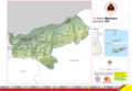
Das Verwaltungsamt Metinaro

Verwaltungsamt Metinaro
Metinaro
Suco Mantelolão
OrtePositionHöheOrtePositionHöhe
Besahe8° 32′ 38″ S, 125° 45′ 54″ O[1]?Lebutun8° 31′ 59″ S, 125° 44′ 48″ O168 m
Suco Sabuli
OrtePositionHöheOrtePositionHöhe
Ayatan8° 32′ 10″ S, 125° 44′ 3″ O104 mWenunuc8° 31′ 48″ S, 125° 44′ 37″ O135 m
Kabura8° 31′ 54″ S, 125° 44′ 19″ O135 mManuleu8° 31′ 52″ S, 125° 44′ 39″ O135 m
Metinaro8° 31′ 50″ S, 125° 44′ 41″ O135 mSabuli8° 31′ 46″ S, 125° 44′ 10″ O104 m
Sukaerlaran8° 31′ 57″ S, 125° 44′ 22″ O135 m
Suco Wenunuc
OrtePositionHöheOrtePositionHöhe
Duyung8° 31′ 43″ S, 125° 45′ 12″ O61 mManleu8° 29′ 18″ S, 125° 50′ 0″ O171 m
Nelayan8° 31′ 23″ S, 125° 45′ 5″ O61 mPriramatan8° 31′ 50″ S, 125° 45′ 4″ O168 m

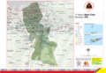
Das Verwaltungsamt Nain Feto

Verwaltungsamt Nain Feto
Nain Feto
Suco Acadiru Hun
OrtePositionHöheOrtePositionHöhe
Ailelehun8° 33′ 23″ S, 125° 35′ 6″ O38 mBelebato8° 33′ 15″ S, 125° 35′ 20″ O84 m
Culuhun de Baixo8° 33′ 21″ S, 125° 35′ 21″ O84 mNu'u Badac8° 33′ 6″ S, 125° 35′ 20″ O43 m
Suco Bemori
OrtePositionHöheOrtePositionHöhe
Bemori Baba Liu Rai8° 33′ 34″ S, 125° 35′ 22″ O84 mBemori Central8° 33′ 27″ S, 125° 35′ 20″ O38 m
Suco Bidau Lecidere
OrtePositionHöheOrtePositionHöhe
Bairo Lecidere8° 33′ 1″ S, 125° 35′ 19″ O[1]m
Suco Gricenfor
OrtePositionHöheOrtePositionHöhe
Bairo Central8° 33′ 17″ S, 125° 35′ 1″ O[1]?Bairo dos Grilos8° 33′ 11″ S, 125° 34′ 59″ O[1]?
Bairo Formosa8° 33′ 18″ S, 125° 34′ 50″ O[1]?
Suco Lahane Oriental
OrtePositionHöheOrtePositionHöhe
Marabia8° 34′ 7″ S, 125° 35′ 19″ O155 mMota Ulun (Ost)8° 34′ 36″ S, 125° 35′ 38″ O261 m
Mota Ulun (West)8° 34′ 25″ S, 125° 35′ 29″ O261 mQuintal Arbiro8° 34′ 3″ S, 125° 35′ 7″ O128 m
Taibesi8° 34′ 4″ S, 125° 35′ 31″ O155 m
Suco Santa Cruz
OrtePositionHöheOrtePositionHöhe
Ailele Hun8° 33′ 23″ S, 125° 35′ 7″ OAudian8° 33′ 25″ S, 125° 34′ 54″ O38 m
Bemori Babaliurai8° 33′ 36″ S, 125° 35′ 15″ OBemori Sentral8° 33′ 31″ S, 125° 35′ 6″ O
Bemori Taibesi8° 33′ 42″ S, 125° 35′ 13″ OQuintal Bot8° 33′ 51″ S, 125° 34′ 57″ O128 m
Quintal Qik8° 33′ 36″ S, 125° 34′ 58″ O38 m

Das Verwaltungsamt Vera Cruz

Verwaltungsamt Vera Cruz
Vera Cruz
Suco Caicoli
OrtePositionHöheOrtePositionHöhe
Borohun8° 33′ 37″ S, 125° 34′ 40″ O11 mCaicoli8° 33′ 33″ S, 125° 34′ 23″ O11 m
Rumbia8° 33′ 46″ S, 125° 34′ 46″ O128 mTahu Laran8° 33′ 52″ S, 125° 34′ 26″ O
Suco Colmera
OrtePositionHöheOrtePositionHöhe
Colmera8° 33′ 23″ S, 125° 34′ 27″ O[1]11 mSoslodade8° 33′ 17″ S, 125° 34′ 23″ O[1]11 m
Suco Dare
OrtePositionHöheOrtePositionHöhe
Casnafar8° 36′ 18″ S, 125° 31′ 45″ O101 mBematua8° 36′ 13″ S, 125° 33′ 42″ O587 m
Dare8° 35′ 44″ S, 125° 34′ 9″ O495 mFatu Naba8° 35′ 35″ S, 125° 34′ 48″ O645 m
Laulara Lama8° 36′ 4″ S, 125° 33′ 9″ O558 mLeilaus8° 36′ 9″ S, 125° 32′ 56″ O?[1]
Nahaec8° 35′ 31″ S, 125° 34′ 57″ O545 m
Suco Lahane Ocidental
OrtePositionHöheOrtePositionHöhe
Aihanexun8° 35′ 2″ S, 125° 34′ 58″ O376 mCorreio8° 34′ 43″ S, 125° 34′ 53″ O248 m
Suco Mascarenhas
OrtePositionHöheOrtePositionHöhe
Balide8° 33′ 54″ S, 125° 34′ 24″ O114 mBispo Medeiros8° 33′ 52″ S, 125° 34′ 42″ O114 m
Mascarenhas8° 34′ 2″ S, 125° 34′ 43″ O114 m
Suco Motael
OrtePositionHöheOrtePositionHöhe
Aitarak8° 32′ 56″ S, 125° 33′ 57″ OmBairo Alto8° 33′ 18″ S, 125° 34′ 7″ Om
Bebora8° 33′ 12″ S, 125° 33′ 56″ OmFarol8° 33′ 12″ S, 125° 34′ 7″ Om
Palapaso8° 32′ 59″ S, 125° 34′ 9″ Om
Suco Vila Verde
OrtePositionHöheOrtePositionHöhe
Banderahun8° 33′ 47″ S, 125° 34′ 1″ O114 mLafandaria8° 33′ 39″ S, 125° 34′ 10″ Om
Mata Doro8° 33′ 32″ S, 125° 34′ 8″ OmManumeta Rahun8° 34′ 1″ S, 125° 34′ 4″ O114 m
Tuanalaran8° 33′ 50″ S, 125° 34′ 9″ O114 mVila Verde8° 33′ 30″ S, 125° 34′ 3″ Om
Virgolosa8° 33′ 45″ S, 125° 34′ 9″ O114 m

Siehe auch

Belege

Die Schreibweise der Ortsnamen folgt, sofern vorhanden, den Angaben zu den administrativen Einteilungen in:

Die Liste der Ortschaften wird mit folgenden Karten erstellt:

Bei unterschiedlicher Schreibweise der Ortsnamen, wird den Angaben des GIS-Portals gefolgt. Die anderen Schreibweisen für einzelne Orte finden sich in den Artikel zu den einzelnen Sucos des Landes.

Die Meereshöhen und Koordinaten wurden entnommen von:

Bei Global Gazetteer aufgeführte Orte, die nicht durch eine Karte bestätigt sind, werden nicht mit in die Liste aufgenommen.

Koordinaten, die nicht bei Global Gazetteer aufgeführt sind, werden mit Hilfe von Google Maps ermittelt.

  1. a b c d e f g h i j k l m n o p q r s t u v w Google Maps

Auf dieser Seite verwendete Medien

Nain Feto posto administrativo.png
Autor/Urheber: , Lizenz: CC BY-SA 2.5
Verwaltungskarte des Subdistrikts Nain Feto in Osttimor
East Timor Dili locator map.svg
Autor/Urheber: NordNordWest, Lizenz: CC BY 3.0
Lagekarte des Distrikts Dili, Osttimor
Sucos Dili.png
Autor/Urheber: J. Patrick Fischer, Lizenz: CC BY-SA 3.0
Sucos des Distrikts Dili/Osttimor nach der Neustrukturierung 2004
Cristo Rei posto administrativo.png
Autor/Urheber: , Lizenz: CC BY-SA 2.5
Verwaltungskarte des Verwaltungsamts Cristo Rei in Osttimor
Vera Cruz posto administrativo.png
Autor/Urheber: , Lizenz: CC BY-SA 2.5
Verwaltungskarte des Subdistrikts Vera Cruz in Osttimor
Metinaro posto administrativo.png
Autor/Urheber: , Lizenz: CC BY-SA 2.5
Verwaltungskarte des Subdistrikts Metinaro/Distrikt Dili in Osttimor
Dom Aleixo posto administrativo.png
Autor/Urheber: , Lizenz: CC BY-SA 2.5
Verwaltungskarte des Verwaltungsamts Dom Aleixo in Dili/Osttimor