Liste der Orte in der Gemeinde Cova Lima

Die Liste der Orte in Cova Lima gibt an, welche Ortschaften in jedem Suco der osttimoresischen Gemeinde Cova Lima liegen und welche geographische Koordinaten und Meereshöhe sie haben.
Landkarten
 Die Gemeinde Cova Lima
 Das Verwaltungsamt Fatululic
 Das Verwaltungsamt Fatumean
 Das Verwaltungsamt Fohorem
 Das Verwaltungsamt Maucatar
 Das Verwaltungsamt Suai
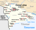 Das Verwaltungsamt Tilomar
 Das Verwaltungsamt Zumalai
Liste
Das Verwaltungsamt Fatululic
| Verwaltungsamt Fatululic | |||||||
| |||||||
| Suco Fatululic | |||||||
| Orte | Position | Höhe | Orte | Position | Höhe | ||
| Aitoun | 9° 12′ 20″ S, 125° 6′ 55″ O | 1542 m | Beco | 9° 11′ 19″ S, 125° 8′ 20″ O | 1189 m | ||
| Beidasi | 9° 11′ 12″ S, 125° 8′ 27″ O[1] | ? | Fatululic | 9° 11′ 27″ S, 125° 7′ 55″ O | 1348 m | ||
| Suco Taroman | |||||||
| Orte | Position | Höhe | Orte | Position | Höhe | ||
| Fatuloro | 9° 13′ 12″ S, 125° 10′ 54″ O | 621 m | Lia Nain | 9° 11′ 38″ S, 125° 10′ 35″ O | 678 m | ||
| Macous | 9° 12′ 40″ S, 125° 10′ 49″ O | 621 m | Taroman | 9° 11′ 52″ S, 125° 10′ 39″ O | 692 m | ||
| Tialai | 9° 12′ 4″ S, 125° 10′ 48″ O[1] | ? | |||||
Das Verwaltungsamt Fatumean
| Verwaltungsamt Fatumean | |||||||
| |||||||
| Suco Belulic Leten | |||||||
| Orte | Position | Höhe | Orte | Position | Höhe | ||
| Belulic Craic | 9° 13′ 16″ S, 125° 1′ 15″ O | 766 m | Belulic Leten | 9° 14′ 38″ S, 125° 0′ 5″ O | 852 m | ||
| Bibitali | 9° 15′ 2″ S, 125° 0′ 49″ O | 674 m | Clau Halec | 9° 15′ 15″ S, 125° 0′ 18″ O[1] | ? | ||
| Kunsabibi | 9° 14′ 50″ S, 125° 0′ 38″ O | 775 m | Mane Quic | 9° 15′ 8″ S, 124° 59′ 48″ O | 887 m | ||
| Sabaama | 9° 14′ 47″ S, 125° 1′ 13″ O | 674 m | Takasana | 9° 14′ 56″ S, 125° 0′ 38″ O | 775 m | ||
| We Bua | 9° 13′ 24″ S, 125° 1′ 14″ O[1] | ? | |||||
| Suco Fatumea | |||||||
| Orte | Position | Höhe | Orte | Position | Höhe | ||
| Aisik | 9° 14′ 8″ S, 125° 2′ 51″ O | 880 m | Fatumea | 9° 13′ 45″ S, 125° 2′ 9″ O | 877 m | ||
| Lebo | 9° 13′ 48″ S, 125° 2′ 12″ O[1] | 877 m | Moata Ulun | 9° 13′ 15″ S, 125° 4′ 19″ O | 1185 m | ||
| Suco Nanu | |||||||
| Orte | Position | Höhe | Orte | Position | Höhe | ||
| Buhutaran | 9° 17′ 1″ S, 125° 1′ 41″ O | 681 m | Makokon | 9° 17′ 50″ S, 125° 2′ 55″ O | 521 m | ||
| Nanu | 9° 16′ 23″ S, 125° 1′ 55″ O | 645 m | Tradu Cama | 9° 16′ 50″ S, 125° 1′ 34″ O | 681 m | ||
Das Verwaltungsamt Fohorem
Das Verwaltungsamt Maucatar
| Verwaltungsamt Maucatar | |||||||
| |||||||
| Suco Belecasac | |||||||
| Orte | Position | Höhe | Orte | Position | Höhe | ||
| Hasain | 9° 16′ 5″ S, 125° 18′ 9″ O | 116 m | Ila | 9° 16′ 4″ S, 125° 18′ 10″ O[1] | ? | ||
| Suco Holpilat | |||||||
| Orte | Position | Höhe | Orte | Position | Höhe | ||
| Ager | 9° 11′ 7″ S, 125° 12′ 21″ O | 642 m | Airik | 9° 13′ 53″ S, 125° 13′ 10″ O | 685 m | ||
| Holpilat | 9° 13′ 23″ S, 125° 12′ 53″ O | 741 m | Holuban | 9° 12′ 47″ S, 125° 12′ 34″ O | 860 m | ||
| Lela | 9° 11′ 22″ S, 125° 12′ 26″ O | 599 m | Leogore | 9° 14′ 11″ S, 125° 13′ 11″ O | 685 m | ||
| Manulor | 9° 13′ 5″ S, 125° 12′ 42″ O | 860 m | Nainare | 9° 12′ 27″ S, 125° 12′ 41″ O | 759 m | ||
| Suco Matai | |||||||
| Orte | Position | Höhe | Orte | Position | Höhe | ||
| Lohorai | 9° 18′ 9″ S, 125° 17′ 2″ O | 30 m | Maior | 9° 17′ 53″ S, 125° 15′ 24″ O | 70 m | ||
| Matai | 9° 17′ 57″ S, 125° 15′ 55″ O | 61 m | My Krus Minar | 9° 18′ 3″ S, 125° 16′ 0″ O[1] | 61 m | ||
| Quiar | 9° 18′ 21″ S, 125° 16′ 30″ O | 29 m | |||||
| Suco Ogues | |||||||
| Orte | Position | Höhe | Orte | Position | Höhe | ||
| Baulela | 9° 17′ 29″ S, 125° 13′ 53″ O | 163 m | Bergel | 9° 14′ 34″ S, 125° 14′ 8″ O[1] | ? | ||
| Foho Rua | 9° 17′ 35″ S, 125° 14′ 0″ O | 163 m | Oges | 9° 15′ 52″ S, 125° 12′ 50″ O | 460 m | ||
| Ogues | 9° 17′ 32″ S, 125° 14′ 2″ O | 163 m | |||||
Das Verwaltungsamt Suai
| Verwaltungsamt Suai | |||||||
| |||||||
| Suco Beco | |||||||
| Orte | Position | Höhe | Orte | Position | Höhe | ||
| Aidantuic | 9° 14′ 4″ S, 125° 22′ 11″ O | 97 m | Bakau | 9° 14′ 9″ S, 125° 23′ 45″ O[1] | ? | ||
| Beco | 9° 12′ 35″ S, 125° 23′ 44″ O | 115 m | Beco 1 | 9° 13′ 20″ S, 125° 23′ 24″ O[1] | ? | ||
| Haemanu | 9° 15′ 14″ S, 125° 20′ 44″ O | 71 m | Lewalu | 9° 8′ 18″ S, 125° 21′ 21″ O | 276 m | ||
| Maucola | 9° 12′ 15″ S, 125° 23′ 54″ O | 100 m | Teda | 9° 8′ 21″ S, 125° 20′ 26″ O | 330 m | ||
| Tobur | 9° 8′ 18″ S, 125° 19′ 28″ O | 621 m | |||||
| Suco Camenaça | |||||||
| Orte | Position | Höhe | Orte | Position | Höhe | ||
| Camenaça | 9° 19′ 9″ S, 125° 17′ 1″ O | 1 m | Futuisin | 9° 19′ 20″ S, 125° 16′ 59″ O | 0 m | ||
| Manequin | 9° 19′ 3″ S, 125° 16′ 47″ O | 1 m | Sanfuc | 9° 18′ 18″ S, 125° 17′ 47″ O | 6 m | ||
| Suco Debos | |||||||
| Orte | Position | Höhe | Orte | Position | Höhe | ||
| Ahinarai | 9° 18′ 47″ S, 125° 15′ 26″ O | 13 m | Asumaten | 9° 19′ 9″ S, 125° 15′ 45″ O | 8 m | ||
| Bonuc | 9° 19′ 4″ S, 125° 15′ 7″ O[1] | ? | Busacucun | 9° 19′ 42″ S, 125° 13′ 47″ O | 51 m | ||
| Busakukua | 9° 19′ 38″ S, 125° 14′ 2″ O[1] | ? | Fatukoan | 9° 20′ 33″ S, 125° 12′ 11″ O | 111 m | ||
| Kulit | 9° 19′ 1″ S, 125° 9′ 38″ O | 300 m | Laconac Babu | 9° 20′ 14″ S, 125° 12′ 23″ O | 98 m | ||
| Laconac Besic | 9° 20′ 1″ S, 125° 13′ 14″ O | 79 m | Lookeu | 9° 17′ 41″ S, 125° 13′ 21″ O[1] | ? | ||
| Orun | 9° 18′ 17″ S, 125° 14′ 49″ O | 29 m | Serankotek | 9° 19′ 34″ S, 125° 14′ 12″ O | 51 m | ||
| Suai | 9° 18′ 45″ S, 125° 15′ 20″ O | 13 m | Talioan | 9° 19′ 47″ S, 125° 14′ 42″ O | 23 m | ||
| Suco Labarai | |||||||
| Orte | Position | Höhe | Orte | Position | Höhe | ||
| Dais | 9° 17′ 6″ S, 125° 18′ 55″ O | 22 m | Holba | 9° 15′ 58″ S, 125° 19′ 34″ O | 79 m | ||
| Holbelis | 9° 18′ 5″ S, 125° 17′ 23″ O | 22 m | Meop | 9° 15′ 59″ S, 125° 19′ 36″ O | 79 m | ||
| Suco Suai Loro | |||||||
| Orte | Position | Höhe | Orte | Position | Höhe | ||
| Acar Laran | 9° 21′ 1″ S, 125° 14′ 46″ O | 6 m | Audian | 9° 19′ 58″ S, 125° 16′ 41″ O | 0 m | ||
| Beimau | 9° 20′ 49″ S, 125° 16′ 58″ O | 0 m | Lo'o | 9° 20′ 52″ S, 125° 16′ 39″ O | 1 m | ||
| Mane Icun | 9° 20′ 49″ S, 125° 16′ 11″ O | 0 m | Sucabe Laran | 9° 20′ 6″ S, 125° 15′ 46″ O | 1 m | ||
| Suco Loro | 9° 20′ 44″ S, 125° 16′ 27″ O | 0 m | Sularan | 9° 20′ 30″ S, 125° 16′ 27″ O | 0 m | ||
Das Verwaltungsamt Tilomar
| Verwaltungsamt Tilomar | |||||||
| |||||||
| Suco Beiseuc | |||||||
| Orte | Position | Höhe | Orte | Position | Höhe | ||
| Baer | 9° 18′ S, 125° 5′ O | 357 m | Fatuc Metan | 9° 20′ 54″ S, 125° 5′ 31″ O | 353 m | ||
| Foholulic | 9° 18′ 39″ S, 125° 4′ 6″ O | 496 m | Maubesi | 9° 19′ 49″ S, 125° 3′ 52″ O | 514 m | ||
| Niquiir | 9° 20′ 44″ S, 125° 4′ 18″ O | 428 m | Tulaeduc Bawah | 9° 25′ 26″ S, 125° 6′ 43″ O | 18 m | ||
| Walabaru | 9° 26′ 3″ S, 125° 6′ 25″ O | 15 m | Walatama | 9° 21′ 43″ S, 125° 4′ 54″ O | 341 m | ||
| We Taba | 9° 25′ 17″ S, 125° 6′ 45″ O[1] | ? | |||||
| Suco Casabauc | |||||||
| Orte | Position | Höhe | Orte | Position | Höhe | ||
| Casabauc 1 | 9° 23′ 0″ S, 125° 11′ 45″ O | 81 m | Casabauc 2 | 9° 23′ 2″ S, 125° 12′ 18″ O | 44 m | ||
| Cawa Uman | 9° 22′ 9″ S, 125° 11′ 8″ O | 126 m | Coloama | 9° 22′ 50″ S, 125° 11′ 18″ O[1] | ? | ||
| Maudemo | 9° 22′ 49″ S, 125° 11′ 13″ O | 98 m | Tabolo | 9° 21′ 11″ S, 125° 11′ 12″ O | 156 m | ||
| Suco Lalawa | |||||||
| Orte | Position | Höhe | Orte | Position | Höhe | ||
| Ai Oan | 9° 20′ 38″ S, 125° 7′ 22″ O[1] | ? | Halemea | 9° 20′ 32″ S, 125° 6′ 51″ O | 328 m | ||
| Halemea Bawah | 9° 24′ 21″ S, 125° 8′ 30″ O | 35 m | Kota Foun | 9° 20′ 35″ S, 125° 7′ 6″ O | 328 m | ||
| Maudemo | 9° 20′ 46″ S, 125° 6′ 45″ O | 324 m | Salale Bot | 9° 24′ 41″ S, 125° 7′ 29″ O | ? | ||
| Tilomar | 9° 20′ 26″ S, 125° 6′ 48″ O | 328 m | Tulaeduc | 9° 20′ 5″ S, 125° 6′ 3″ O | 18 m | ||
| Suco Maudemo | |||||||
| Orte | Position | Höhe | Orte | Position | Höhe | ||
| Besac Oan | 9° 23′ 39″ S, 125° 9′ 36″ O[1] | ? | Caicoli | 9° 23′ 21″ S, 125° 10′ 8″ O[1] | ? | ||
| Kuitaok | 9° 21′ 57″ S, 125° 9′ 40″ O | 190 m | Salele | 9° 23′ 25″ S, 125° 9′ 51″ O[1] | 16 m | ||
Das Verwaltungsamt Zumalai
| Verwaltungsamt Zumalai | |||||||
| |||||||
| Suco Fatuleto | |||||||
| Orte | Position | Höhe | Orte | Position | Höhe | ||
| Lale | 9° 6′ 56″ S, 125° 24′ 51″ O | 310 m | Loegolo | 9° 7′ 4″ S, 125° 25′ 8″ O | 310 m | ||
| Zulo Tas | 9° 6′ 45″ S, 125° 24′ 42″ O | 311 m | |||||
| Suco Lepo | |||||||
| Orte | Position | Höhe | Orte | Position | Höhe | ||
| Zulo | 9° 6′ 36″ S, 125° 24′ 30″ O | 320 m | Zulo Tas | 9° 6′ 45″ S, 125° 24′ 42″ O | 311 m | ||
| Suco Lour | |||||||
| Orte | Position | Höhe | Orte | Position | Höhe | ||
| Salasa | 9° 8′ 18″ S, 125° 27′ 37″ O | 244 m | |||||
| Suco Mape | |||||||
| Keine größeren Orte im Suco | |||||||
| Suco Raimea | |||||||
| Orte | Position | Höhe | Orte | Position | Höhe | ||
| Audian | 9° 11′ 53″ S, 125° 27′ 14″ O | 82 m | Bebora | 9° 11′ 16″ S, 125° 30′ 6″ O[1] | ? | ||
| Beilaco A | 9° 11′ 51″ S, 125° 29′ 3″ O | 82 m | Beilaco B | 9° 12′ 1″ S, 125° 29′ 5″ O | 82 m | ||
| Fatukao | 9° 10′ 25″ S, 125° 27′ 13″ O | 157 m | Hare Cain | 9° 11′ 1″ S, 125° 29′ 15″ O | 145 m | ||
| Heli Key | 9° 10′ 52″ S, 125° 28′ 59″ O[1] | ? | Holitol | 9° 11′ 16″ S, 125° 29′ 51″ O | 115 m | ||
| Leonti | 9° 10′ 47″ S, 125° 28′ 31″ O | 138 m | Lepokanua | 9° 8′ 54″ S, 125° 27′ 33″ O | 232 m | ||
| Loro | 9° 12′ 41″ S, 125° 27′ 44″ O | 63 m | Mape | 9° 9′ 18″ S, 125° 27′ 13″ O | 199 m | ||
| Naguidal | 9° 8′ 40″ S, 125° 27′ 32″ O | 244 m | Oebata | 9° 11′ 19″ S, 125° 30′ 59″ O | 106 m | ||
| Oerbora | 9° 11′ 17″ S, 125° 30′ 10″ O | 115 m | Oeulitai | 9° 11′ 20″ S, 125° 30′ 36″ O | 114 m | ||
| Raifila | 9° 10′ 41″ S, 125° 28′ 7″ O | 166 m | Raimea | 9° 12′ 42″ S, 125° 27′ 44″ O | 63 m | ||
| Uma Claran | 9° 12′ 49″ S, 125° 27′ 41″ O | 45 m | Zobete | 9° 9′ 56″ S, 125° 26′ 57″ O | 180 m | ||
| Suco Tashilin | |||||||
| Orte | Position | Höhe | Orte | Position | Höhe | ||
| Baura Icun | 9° 12′ 0″ S, 125° 24′ 38″ O | 106 m | Culu Oan | 9° 13′ 22″ S, 125° 26′ 9″ O | 30 m | ||
| Galitaz | 9° 11′ 45″ S, 125° 25′ 26″ O | 118 m | Holgeda | 9° 11′ 25″ S, 125° 25′ 41″ O | 118 m | ||
| Karetamute | 9° 10′ 39″ S, 125° 26′ 22″ O | 150 m | Obugmil | 9° 11′ 0″ S, 125° 26′ 5″ O | 140 m | ||
| Tashilin | 9° 11′ 50″ S, 125° 25′ 16″ O | 92 m | |||||
| Suco Ucecai | |||||||
| Keine größeren Orte im Suco | |||||||
| Suco Zulo | |||||||
| Orte | Position | Höhe | Orte | Position | Höhe | ||
| Dilukede | 9° 9′ 44″ S, 125° 26′ 48″ O | 199 m | Maliseran | 9° 9′ 56″ S, 125° 26′ 35″ O | 169 m | ||
| Quimaque | 9° 4′ 29″ S, 125° 23′ 5″ O[1] | ? | Zulokota | 9° 9′ 14″ S, 125° 27′ 1″ O | 210 m | ||
| Zumalai | 9° 9′ 27″ S, 125° 27′ 2″ O | 199 m | |||||
Siehe auch
Belege
Die Schreibweise der Ortsnamen folgt, sofern vorhanden, den Angaben zu den administrativen Einteilungen in:
- Jornal da Républica mit dem Diploma Ministerial n.° 199/09 ( vom 3. Februar 2010 im Internet Archive) (portugiesisch; PDF; 323 kB)
Die Liste der Ortschaften wird mit folgenden Karten erstellt:
- Timor-Leste GIS-Portal ( vom 30. Juni 2007 im Internet Archive)
- UNMIT Karten der Distrikte 2008
Bei unterschiedlicher Schreibweise der Ortsnamen, wird den Angaben des GIS-Portals gefolgt. Die anderen Schreibweisen für einzelne Orte finden sich in den Artikel zu den einzelnen Sucos des Landes.
Die Meereshöhen und Koordinaten wurden entnommen von:
Bei Global Gazetteer aufgeführte Orte, die nicht durch eine Karte bestätigt sind, werden nicht mit in die Liste aufgenommen.
Koordinaten, die nicht bei Global Gazetteer aufgeführt sind, werden mit Hilfe von Google Maps ermittelt.
Die administrativen Grenzen innerhalb Osttimors haben sich 2015 geändert. Dieser Artikel muss daher geprüft und gegebenenfalls aktualisiert werden. Siehe Neue administrative Grenzen.
Auf dieser Seite verwendete Medien
(c) OOjs UI Team and other contributors, MIT
An icon from the OOjs UI MediaWiki lib.

(c) Karte: NordNordWest, Lizenz: Creative Commons by-sa-3.0 de
Positionskarte von Osttimor


Autor/Urheber:
- Administrative_map_of_the_Covalima_district_of_East_Timor.png: Maximilian Dörrbecker (Chumwa)
- derivative work: J. Patrick Fischer
Verwaltungskarte des Subdistrikts Zumalai in Osttimor

Autor/Urheber:
- Administrative_map_of_the_Covalima_district_of_East_Timor.png: Maximilian Dörrbecker (Chumwa)
- derivative work: J. Patrick Fischer
Verwaltungskarte des Verwaltungsamts Fatumean in Osttimor

Autor/Urheber:
- Administrative_map_of_the_Covalima_district_of_East_Timor.png: Maximilian Dörrbecker (Chumwa)
- derivative work: J. Patrick Fischer
Verwaltungskarte des Verwaltungsamts Fohorem in Osttimor

Autor/Urheber:
- Administrative_map_of_the_Covalima_district_of_East_Timor.png: Maximilian Dörrbecker (Chumwa)
- derivative work: J. Patrick Fischer
Verwaltungskarte des Subdistrikts Tilomar in Osttimor

Autor/Urheber:
- Administrative_map_of_the_Covalima_district_of_East_Timor.png: Maximilian Dörrbecker (Chumwa)
- derivative work: J. Patrick Fischer
Verwaltungskarte des Subdistrikts Suai in Osttimor

Autor/Urheber:
- Administrative_map_of_the_Covalima_district_of_East_Timor.png: Maximilian Dörrbecker (Chumwa)
- derivative work: J. Patrick Fischer
Verwaltungskarte des Subdistrikts Maucatar in Osttimor

Autor/Urheber: J. Patrick Fischer, Lizenz: CC BY-SA 3.0
Sucos des Distrikts Cova Lima/Osttimor nach der Neustrukturierung 2004
Autor/Urheber: J. Patrick Fischer, Lizenz: CC BY-SA 4.0
Lagekarte der Gemeinde Cova Lima seit 2015, Osttimor

Autor/Urheber:
- Administrative_map_of_the_Covalima_district_of_East_Timor.png: Maximilian Dörrbecker (Chumwa)
- derivative work: J. Patrick Fischer
Verwaltungskarte des Verwaltungsamts Fatululic in Osttimor