Liste der Highways in Ontario
Diese Liste stellt eine Übersicht über die Highways in der ostkanadischen Provinz Ontario dar. Die sogenannte 400er Serie besteht aus autobahnähnlich ausgebauten Strecken (Freeways bzw. Expressways). Die Highways in Ontario stehen unter Verwaltung der Provinz, einzige Ausnahme bildet der 407 ETR, der privat finanziert wurde und unter Verwaltung von 407 ETR Concession Company Limited.[1]
400er Serie
| Zeichen | Nummer | Name | Beginn | Ende | Länge in km |
|---|---|---|---|---|---|
| 400 | Toronto–Barrie Highway | Nobel, weiter auf | Toronto | 226 | |
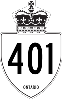
| 401 | Macdonald–Cartier Freeway | Windsor, weiter auf | South Glengarry, weiter auf | 818 | |
| 402 | Point Edward, weiter auf | London, weiter auf | 103 | ||
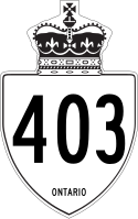
| 403 | Chedoke Expressway | Woodstock, weiter auf | Mississauga, weiter auf | 125 | |
| 404 | Toronto, weiter auf | East Gwillimbury | 37 | ||
| 405 | General Brock Parkway | St. Catharines, weiter auf | Niagara Falls, weiter auf | 9 | |
| 406 | Thorold, weiter auf | St. Catharines, weiter auf | 26 | ||
| 407 | Express Toll Route | Burlington, weiter auf | Pickering, weiter auf | 107 | |
| 409 | Belfield Expressway | Pearson Airport | Toronto, weiter auf | 6 | |
| 410 | Mississauga, weiter auf | Caledon, weiter auf | 20 | ||
| 416 | Veterans Memorial Highway | Johnstown, weiter auf | Ottawa, weiter auf | 76 | |
| 417 | Queensway | Arnprior, weiter auf | East Hawkesbury, weiter auf | 181 | |
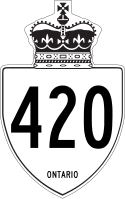
| 420 | Niagara Veterans Memorial Highway | Niagara Falls | Niagara Falls | 3 | |
| 427 | Toronto, weiter auf | Vaughan | 20 | ||
| QEW | Queen Elizabeth Way | Fort Erie | Toronto, weiter auf | 139 |
The King's Highways
| Zeichen | Nummer | Name | Beginn | Ende | Länge in km |
|---|---|---|---|---|---|
| 2 | Gananoque | Gananoque, weiter auf | 1 | ||
| 3 | Talbot Trail | Windsor, weiter auf | Fort Erie | 261 | |
| 4 | St. Thomas, weiter auf | Clinton, weiter auf | 101 | ||
| 5 | Dundas, weiter auf | Waterdown, weiter auf | 13 | ||
| 6 | Garafraxa Road | Port Dover | Baldwin, weiter auf | 480 | |
| 7 | Elginfield, weiter auf | Norval | 153 | ||
| Markham | Kanata, weiter auf | 384 | |||
| 7A | Port Perry, weiter auf | Peterborough, weiter auf | 48 | ||
| 8 | Goderich, weiter auf | Dundas, weiter auf | 139 | ||
| 9 | Kincardine, weiter auf | Harriston, weiter auf | 73 | ||
| Orangeville, weiter auf | Newmarket, weiter auf | 46 | |||
| 10 | Hurontario Street | Caledon, weiter auf | Owen Sound, weiter auf | 136 | |
| 11 | Cochrane, weiter auf | Barrie, weiter auf | 1780 | ||
| 12 | Brooklin | Midland, weiter auf | 145 | ||
| 15 | Kingston, weiter auf | Carleton Place, weiter auf | 113 | ||
| 16 | Prescott, weiter auf | Prescott, weiter auf | 4 | ||
| 17 | Trans-Canada Highway | Kenora, weiter auf | Arnprior, weiter auf | 1964 | |
| 17A | Kenora Bypass | Keewatin, weiter auf | Kenora, weiter auf | 34 | |
| 19 | Tillsonburg, weiter auf | Ingersoll, weiter auf | 24 | ||
| 20 | Lundy's Lane | Allanburg, weiter auf | Niagara Falls | 2 | |
| 21 | Bluewater Highway | Wyoming, weiter auf | Owen Sound, weiter auf | 227 | |
| 23 | Elginfield, weiter auf | Owen Sound, weiter auf | 98 | ||
| 24 | Simcoe, weiter auf | Cambridge | 65 | ||
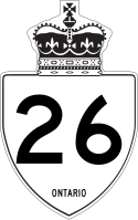
| 26 | Owen Sound, weiter auf | Barrie, weiter auf | 116 | ||
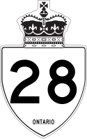
| 28 | Peterborough, weiter auf | Denbigh, weiter auf | 163 | ||
| 33 | Loyalist Parkway | Bloomfield, weiter auf | Kingston | 61 | |
| 34 | Vankleek Hill, weiter auf | Hawkesbury, weiter auf | 17 | ||
| 35 | Newcastle, weiter auf | Algonquin Park, weiter auf | 196 | ||
| 37 | Belleville, weiter auf | Actinolite, weiter auf | 44 | ||
| 40 | Chatham–Kent, weiter auf | Sarnia, weiter auf | 92 | ||
| 41 | Kaladar, weiter auf | Pembroke, weiter auf | 161 | ||
| 48 | Markham Road | Markham | Beaverton, weiter auf | 63 | |
| 49 | Prince Edward County | Marysville | 6 | ||
| 58 | Port Colborne, weiter auf | Welland, weiter auf | 7 | ||
| Allanburg, weiter auf | Thorold, weiter auf | 8 | |||
| 58A | Townline Tunnel | Welland, weiter auf | Welland, weiter auf | 4 | |
| 60 | Frank A. McDougall Parkway | Huntsville, weiter auf | Renfrew, weiter auf | 256 | |
| 61 | Neebing, weiter auf | Thunder Bay, weiter auf | 61 | ||
| 62 | Bloomfield, weiter auf | Maynooth, weiter auf | 166 | ||
| 63 | North Bay | Thorne, weiter auf | 64 | ||
| 64 | Rutter, weiter auf | Marten River, weiter auf | 145 | ||
| 65 | Matachewan, weiter auf | Casey Township, weiter auf | 123 | ||
| 66 | Matachewan | Larder Lake, weiter auf | 102 | ||
| 67 | Porquis Junction, weiter auf | Iroquois Falls | 11 | ||
| 69 | Trans-Canada Highway | MacTier, weiter auf | Sudbury, weiter auf | 198 | |
| 71 | Trans-Canada Highway | Fort Frances, weiter auf | Kenora, weiter auf | 194 | |
| 72 | Dinorwic, weiter auf | Sioux Lookout | 69 | ||
| 77 | Leamington, weiter auf | Comber, weiter auf | 23 | ||
| 85 | Kitchener | St. Jacobs | 10 | ||
| 89 | Harriston, weiter auf | Cookstown, weiter auf | 107 | ||
| 93 | Barrie, weiter auf | Midland, weiter auf | 24 | ||
| 94 | Callander | Corbeil, weiter auf | 12 | ||
| 101 | Wawa, weiter auf | Black River-Matheson, weiter auf | 473 | ||
| 102 | Sistonens Corners, weiter auf | Thunder Bay, weiter auf | 33 | ||
| 105 | Vermilion Bay, weiter auf | Red Lake | 174 | ||
| 108 | Serpent River, weiter auf | Elliot Lake | 42 | ||
| 112 | Tarzwell, weiter auf | Kirkland Lake, weiter auf | 20 | ||
| 115 | Newcastle, weiter auf | Peterborough, weiter auf | 57 | ||
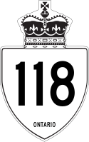
| 118 | Bracebridge, weiter auf | Bancroft, weiter auf | 128 | ||
| 124 | Parry Sound, weiter auf | Sundridge, weiter auf | 75 | ||
| 125 | Red Lake, weiter auf | Cochenour | 14 | ||
| 127 | Maynooth, weiter auf | Whitney, weiter auf | 39 | ||
| 129 | Thessalon, weiter auf | Chapleau | 221 | ||
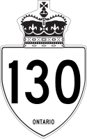
| 130 | Thunder Bay, weiter auf | Thunder Bay, weiter auf | 15 | ||
| 132 | Dacre, weiter auf | Renfrew, weiter auf | 30 | ||
| 137 | Hill Island, weiter auf | Lansdowne, weiter auf | 4 | ||
| 138 | Cornwall | Casselman, weiter auf | 39 | ||
| 140 | Port Colborne, weiter auf | Welland | 11 | ||
| 141 | Parry Sound, weiter auf | Port Sydney, weiter auf | 54 | ||
| 144 | Sudbury, weiter auf | Timmins, weiter auf | 272 | ||
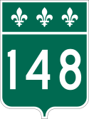
| 148 | Pembroke | Cotnam Island, weiter auf | 7 |
Einzelnachweise
- ↑ 407 ETR - Homepage des Betreibers. Abgerufen am 25. April 2012 (englisch).
Auf dieser Seite verwendete Medien
A picture of the special shield of the Macdonald-Cartier Freeway (Ontario Provincial Highway 401).
This picture is intended for description and is not intended to be authoritative.
This is a rough approximation of the marker used on King's Highways in Ontario, modified from Image:Ontario Junction template.svg
Minnesota State Highway route marker
Highway 407's crest across the route.
Minnesota State Highway route marker
Diagram of a 750 mm by 600 mm (30 in by 24 in) route marker for New York State Route 812, made to the specifications of the Manual on Uniform Traffic Control Devices (MUTCD), 2009 Edition (sign M1-5; p. 143) and the 2010 New York state supplement to the MUTCD (signs NYM3-1, NYM3-2, and NYM3-3; pp. 73, 256). Uses the Roadgeek 2005 fonts. (United States law does not permit the copyrighting of typeface designs, and the fonts are meant to be copies of a U.S. Government-produced work anyway.)
600 mm × 600 mm (24 in × 24 in) U.S. Highway shield, made to the specifications of the 2004 edition of Standard Highway Signs. (Note that there is a missing "J" label on the left side of the diagram.) Uses the Roadgeek 2005 fonts. (United States law does not permit the copyrighting of typeface designs, and the fonts are meant to be copies of a U.S. Government-produced work anyway.)
600 mm by 600 mm (24 in by 24 in) Interstate shield, made to the specifications of the 2004 edition of Standard Highway Signs (sign M1-1). Uses the Roadgeek 2005 fonts. (United States law does not permit the copyrighting of typeface designs, and the fonts are meant to be copies of a U.S. Government-produced work anyway.) Colors are from [1] (Pantone Red 187 and Blue 294), converted to RGB by [2]. The outside border has a width of 1 (1 mm) and a color of black so it shows up; in reality, signs have no outside border.
Blank shield with white background of the Trans-Canada Highway
Ontario Highway 17 shield
This is a rough approximation of the marker used on King's Highways in Ontario
Marker sign for Highway 21 (Ontario). This is the logo of a former provincial Highway of Ontario.
Manitoba Highway 1 route marker
600 mm by 600 mm (24 in by 24 in) Interstate shield, made to the specifications of the 2004 edition of Standard Highway Signs (sign M1-1). Uses the Roadgeek 2005 fonts. (United States law does not permit the copyrighting of typeface designs, and the fonts are meant to be copies of a U.S. Government-produced work anyway.) Colors are from [1] (Pantone Red 187 and Blue 294), converted to RGB by [2]. The outside border has a width of 1 (1 mm) and a color of black so it shows up; in reality, signs have no outside border.
This is a rough approximation of the marker used on King's Highways in Ontario.
Autor/Urheber: Floydian (talk), Lizenz: CC BY-SA 2.0
An arrowless trailblazer and directionless reassurance marker for the Gardiner Expressway. These are signed on the expressway with the word 'EAST' or 'WEST' within the yellow circle. On city streets near the expressway, an arrow appears in the circle directing drivers to the nearest onramp.
