Liste der Einträge im National Register of Historic Places im Vermillion County
Die Liste der Einträge im National Register of Historic Places im Vermillion County in Indiana führt alle Bauwerke und historischen Stätten im Vermillion County auf, die in das National Register of Historic Places aufgenommen wurden.[1]
Legende
| NRHP | Historic Place |
|---|---|
| HD | Historic District |
Aktuelle Einträge
| [2] | Name[3] | Bild | Eintragsdatum | Lage | Ort | Beschreibung |
|---|---|---|---|---|---|---|
| 1 | Clinton Downtown Historic District | 2000 ID-Nr. 00000205 | Abgegrenzt durch South Water Street, South 3rd Street, Elm Street und die Gleise der CSX 39° 39′ 33,5″ N, 87° 23′ 53,8″ W | Clinton | ||
| 2 | Eugene Covered Bridge | 1994 ID-Nr. 94000585 | Brücke der früheren County Road 00 über den Big Vermilion River bei Eugene 39° 58′ 9″ N, 87° 28′ 23″ W | Eugene | ||
| 3 | Hill Crest Community Center | 1997 ID-Nr. 97001555 | 505 North 8th Street 39° 40′ 25″ N, 87° 24′ 25″ W | Clinton | ||
| 4 | Newport Covered Bridge | 1994 ID-Nr. 94000589 | Brücke der County Road 50N über den Little Vermilion River, nordwestlich von Newport 39° 53′ 29″ N, 87° 26′ 0″ W | Newport | ||
| 5 | Possum Bottom Covered Bridge | 1994 ID-Nr. 94000584 | Nordseite des US 36, rund 300 m östlich der Kreuzung mit der East Road 39° 47′ 50″ N, 87° 27′ 12″ W | Dana | ||
| 6 | Salem Methodist Episcopal Church | 1979 ID-Nr. 79000022 | Nördlich von Clinton an der IN 63 39° 43′ 55″ N, 87° 23′ 58″ W | Clinton | ||
| 7 | Vermillion County Courthouse | 2007 ID-Nr. 07001283 | 255 South Main Street 39° 53′ 5″ N, 87° 24′ 34″ W | Newport | ||
| 8 | Vermillion County Jail and Sheriff's Residence | 1999 ID-Nr. 99000305 | 220 East Market Street 39° 51′ 27″ N, 87° 24′ 22″ W | Newport |
Frühere Einträge
| [2] | Name[3] | Bild | Eintragsdatum | Lage | Ort | Beschreibung |
|---|---|---|---|---|---|---|
| 1 | Brouilletts Creek Covered Bridge | 1994 ID-Nr. 94000586 | County Roads 100W and 1700S über den Brouilletts Creek 39° 38′ 10,6″ N, 87° 24′ 19,9″ W | Clinton | 1999 aus dem Register gestrichen[4] |
Siehe auch
Einzelnachweise
- ↑ Auszug aus dem National Register of Historic Places - Vermillion County Abgerufen am 29. November 2012
- ↑ a b Die Nummerierung in dieser Listenspalte ist an der vom National Park Service vorgelegten Reihenfolge der Einträge orientiert; die Farben unterscheiden verschiedene Schutzgebietstypen des National Park Systems mit landesweiter Bedeutung (z. B. National Historic Landmarks) von den sonstigen Einträgen im National Register of Historic Places.
- ↑ a b National Register Information System. In: National Register of Historic Places. National Park Service. Abgerufen am 9. Juli 2010.
- ↑ Bridgehunter.com Abgerufen am 29. November 2012
Auf dieser Seite verwendete Medien
Western portal and southern side of the Possum Bottom Covered Bridge, located in the Ernie Pyle Rest Park on the northern side of U.S. Route 36 southeast of Dana in Helt Township, Vermillion County, Indiana, United States. Built in 1876, it is listed on the National Register of Historic Places.
Southern portal and eastern side of the Eugene Covered Bridge, which formerly carried County Road 0 over the Vermilion River at Eugene in Eugene Township, Vermillion County, Indiana, United States. Built in 1873, it is listed on the National Register of Historic Places.
The east face of the Vermillion County Courthouse in Newport, Indiana, photographed from Main Street during the 2009 Newport Antique Auto Hill Climb.
Front and western side of the Vermillion County Jail and Sheriff's Residence, located at 220 E. Market Street in Newport, Indiana, United States. Built in 1868 and now the Vermillion County Historical Society's museum, it is listed on the National Register of Historic Places.
Northern portal and western side of the Newport Covered Bridge, which carries County Road 50N over the Little Vermilion River northwest of Newport in Vermillion Township, Vermillion County, Indiana, United States. Built in 1885, it is listed on the National Register of Historic Places.
Front and eastern side of the Hill Crest Community Center, located at 505 N. Eighth Street in Clinton, Indiana, United States. Built in 1911, it is listed on the National Register of Historic Places.
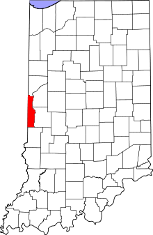
This is a locator map showing Vermillion County in Indiana. For more information, see Commons:United States county locator maps.
Front and eastern side of Salem United Methodist Church, located on the northwestern corner of the junction of State Road 63 and County Road 1050S north of Clinton in Helt Township, Vermillion County, Indiana, United States. Built in 1878, it is listed on the National Register of Historic Places.
Buildings on the western side of the 100 block of S. Main Street in Clinton, Indiana, United States. From left to right, they are:
- 145 S. Main, none, 1915
- 141 S. Main, Neoclassical, 1910 — formerly Citizens Bank
- 139 S. Main, Italianate, 1900
- 137 S. Main, Queen Anne, 1900
- 125 S. Main, none, 1910
- 111 S. Main, none, 1910 — shares an address with its neighbor
- 111 S. Main, Neoclassical, 1915 — shares an address with its neighbor


