Liste der Einträge im National Register of Historic Places im Tazewell County (Illinois)

Die Liste der Einträge im National Register of Historic Places im Tazewell County in Illinois führt alle Bauwerke und historischen Stätten im Tazewell County auf, die in das National Register of Historic Places aufgenommen wurden.[1]
Legende
| NRHP | Historic Place |
|---|---|
| HD | Historic District |
Aktuelle Einträge
| [2] | Name[3] | Bild | Eintragsdatum | Lage | Ort | Beschreibung |
|---|---|---|---|---|---|---|
| 1 | Allentown Union Hall | _from_SE_2.jpg) | 1988 ID-Nr. 88001228 | Rund 3 km östlich der IL 121 40° 33′ 18,5″ N, 89° 23′ 49,9″ W | Allentown | |
| 2 | Ayer Public Library |  | 1998 ID-Nr. 98001352 | 200 Locust Street 40° 22′ 27,3″ N, 89° 32′ 49″ W | Delavan | |
| 3 | Cemetery Road Bridge |  | 1998 ID-Nr. 98000467 | Candlewood Drive auf dem Gelände des Glendale Cemetery 40° 41′ 51″ N, 89° 24′ 41″ W | Washington | |
| 4 | Clear Lake Site | 1978 ID-Nr. 78001171 | Kreuzung von 1200E und 2600N in Sand Ridge State Forest 40° 26′ 8″ N, 89° 54′ 0″ W | westlich von Manito | Reicht bis in das benachbarte Mason County | |
| 5 | Delavan Commercial Historic District |  | 1991 ID-Nr. 91001687 | 307, 309-324, 400, 401, 404-410, 412 und 414 Locust Street 40° 22′ 20″ N, 89° 32′ 50″ W | Delavan | |
| 6 | Dement-Zinser House |  | 2002 ID-Nr. 02001411 | 105 Zinser Place 40° 42′ 16″ N, 89° 24′ 26,5″ W | Washington | |
| 7 | Denhart Bank Building |  | 2005 ID-Nr. 05000874 | 101 Washington Square 40° 42′ 14″ N, 89° 24′ 24″ W | Washington | |
| 8 | Farm Creek Section |  | 1992 ID-Nr. 91002039 | Südliches Ufer des Farm Creek 40° 40′ 38″ N, 89° 29′ 23″ W | East Peoria | |
| 9 | Carl Herget Mansion |  | 1992 ID-Nr. 92001005 | 420 Washington Street 40° 33′ 52″ N, 89° 38′ 47″ W | Pekin | |
| 10 | Illinois Traction System Mackinaw Depot | 1978 ID-Nr. 78001192 | 301 North Main Street 40° 32′ 22″ N, 89° 21′ 33,3″ W | Mackinaw | ||
| 11 | Pekin Federal Building |  | 1980 ID-Nr. 80001412 | 334 Elizabeth Street 40° 34′ 8″ N, 89° 38′ 55″ W | Pekin | |
| 12 | Peoria Lock and Dam Historic District | 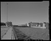 | 2004 ID-Nr. 04000169 | 1071 Wesley Road 40° 33′ 7,9″ N, 89° 28′ 27,2″ W | Creve Coeur | |
| 13 | St. Louis, Peoria and Northern Railroad Depot | 2004 ID-Nr. 04001305 | Block 1900 Broadway 40° 34′ 2,2″ N, 89° 37′ 23,8″ W | Pekin | ||
| 14 | Tazewell County Courthouse |  | 1985 ID-Nr. 85002837 | Court Street zwischen Capitol Street und 4th Street 40° 34′ 9″ N, 89° 38′ 52″ W | Pekin | |
| 15 | Third Street Bridge | 1999 ID-Nr. 99000586 | 3rd Street zwischen Pine Street und Elm Street 40° 22′ 24,6″ N, 89° 32′ 40,6″ W | Delavan | ||
| 16 | Waltmire Bridge | _from_SW_2.jpg) | 1999 ID-Nr. 99000112 | Brücke der Locust Road über den Mackinaw River, rund 8 km südlich von Tremont 40° 26′ 57,4″ N, 89° 29′ 31″ W | Tremont |
Frühere Einträge
| [2] | Name[3] | Bild | Eintragsdatum | Lage | Ort | Beschreibung |
|---|---|---|---|---|---|---|
| 1 | Pekin Theatre | 1982 ID-Nr. 82002601 | 21-29 South Capitol Street 40° 33′ 7,9″ N, 89° 28′ 27,2″ W | Pekin | 1987 aus dem Register gestrichen |
Siehe auch
Einzelnachweise
- ↑ Auszug aus dem National Register of Historic Places – Tazewell County (Memento des Originals vom 12. Mai 2013 im Internet Archive) Info: Der Archivlink wurde automatisch eingesetzt und noch nicht geprüft. Bitte prüfe Original- und Archivlink gemäß Anleitung und entferne dann diesen Hinweis. Abgerufen am 14. Januar 2013
- ↑ a b Die Nummerierung in dieser Listenspalte ist an der vom National Park Service vorgelegten Reihenfolge der Einträge orientiert; die Farben unterscheiden verschiedene Schutzgebietstypen des National Park Systems mit landesweiter Bedeutung (z. B. National Historic Landmarks) von den sonstigen Einträgen im National Register of Historic Places.
- ↑ a b National Register Information System. In: National Register of Historic Places. National Park Service. Abgerufen am 9. Juli 2010.

National Register of Historic Places in Illinois
Adams | Alexander | Bond | Boone | Brown | Bureau | Calhoun | Carroll | Cass | Champaign | Christian | Clark | Clay | Clinton | Coles | Cook (inkl. Chicago) | Crawford | Cumberland | DeKalb | DeWitt | Douglas | DuPage | Edgar | Edwards | Effingham | Fayette | Ford | Franklin | Fulton | Gallatin | Greene | Grundy | Hamilton | Hancock | Hardin | Henderson | Henry | Iroquois | Jackson | Jasper | Jefferson | Jersey | Jo Daviess | Johnson | Kane | Kankakee | Kendall | Knox | LaSalle | Lake | Lawrence | Lee | Livingston | Logan | Macon | Macoupin | Madison | Marion | Marshall | Mason | Massac | McDonough | McHenry | McLean | Menard | Mercer | Monroe | Montgomery | Morgan | Moultrie | Ogle | Peoria | Perry | Piatt | Pike | Pope | Pulaski | Putnam | Randolph | Richland | Rock Island | Saline | Sangamon | Schuyler | Scott | Shelby | St. Clair | Stark | Stephenson | Tazewell | Union | Vermilion | Wabash | Warren | Washington | Wayne | White | Whiteside | Will | Williamson | Winnebago | Woodford
Auf dieser Seite verwendete Medien

Autor/Urheber: Ammodramus, Lizenz: CC0
Third Street Bridge in Delavan, Illinois, carrying Third Street (which runs east-west) across a railroad track; seen from the south.
This is a locator map showing Tazewell County in Illinois. For more information, see Commons:United States county locator maps.
Autor/Urheber: Boscophotos, Lizenz: CC BY-SA 3.0
Denhart Bank Building
Autor/Urheber: Ammodramus, Lizenz: CC0
Federal Building, located at 334 Elizabeth Street in Pekin, Illinois. Elizabeth Street runs northwest-southeast; view in the photo is from the east.
Autor/Urheber: Ammodramus, Lizenz: CC0
Waltmire Bridge, located south of Tremont in Tazewell County, Illinois. The bridge carries a county road named Locust across the Mackinaw River. The bridge is oriented northeast-southwest; the river flows generally northwestward at this point. View in the photo is from the southwest (left is downstream).
Autor/Urheber: Ammodramus, Lizenz: CC0
Allentown Union Hall, located in Allentown, Illinois, an apparently unincorporated settlement located northwest of Mackinaw, Illinos; seen from the southeast.
Autor/Urheber: Ammodramus, Lizenz: CC0
Tazewell County, Illinois courthouse, occupying most of the block between 4th and Capitol and between Elizabeth and Court Streets in Pekin, Illinois. The building's long axis runs northwest-southeast (parallel to Elizabeth and Court). View in the photo is from the southwest (from Capitol).
Autor/Urheber: Boscophotos, Lizenz: CC BY-SA 3.0
Cemetery Road Bridge
Autor/Urheber: Ammodramus, Lizenz: CC0
Herget house, located at 420 Washington Street in Pekin, Illinois; seen from the northwest.
Autor/Urheber: Ammodramus, Lizenz: CC0
Building at 401 Locust Street in Delavan, Illinois. The 1875 building is a contributing property in the Delavan Commercial Historic District, which is listed in the National Register of Historic Places.
Autor/Urheber: Ammodramus, Lizenz: CC0
Farm Creek Section, located in Farmdale Recreation Area, in Tazewell County near East Peoria, Illinois. Fifth in a series of seven photos running from left to right (generally, from east to west, with the camera facing generally southward) along the slope. Farm Creek runs from left to right.

Autor/Urheber: Ammodramus, Lizenz: CC0
Chicago & Alton railroad depot, located in a park at about 20th and Broadway in Pekin, Illinois; seen from the northwest.
Autor/Urheber: Esvobod2, Lizenz: CC BY-SA 3.0
Dement-Zinser House, 105 Zinser Place, Washington, Illinois

Autor/Urheber: Ammodramus, Lizenz: CC0
Ayer Public Library, located at 200 Locust Street in Delavan, Illinois; seen from the west.

Autor/Urheber: Ammodramus, Lizenz: CC0
Railroad depot, located 301 N. Main Street in Mackinaw, Illinois; seen from the northeast.