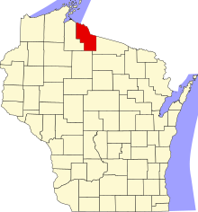
Liste der Einträge im National Register of Historic Places im Iron County (Wisconsin)
Die Liste der Einträge im National Register of Historic Places im Iron County in Wisconsin führt alle Bauwerke und historischen Stätten im Iron County auf, die in das National Register of Historic Places aufgenommen wurden.[1]
Legende
| NRHP | Historic Place |
|---|---|
| HD | Historic District |
Aktuelle Einträge
| [2] | Name[3] | Bild | Eintragsdatum | Lage | Ort | Beschreibung |
|---|---|---|---|---|---|---|
| 1 | Annala Round Barn | 1979 ID-Nr. 79000085 | Dupont Road 46° 25′ 5″ N, 90° 9′ 41″ W | Town of Oma | 1917 errichtete Rundscheune des finnischen Einwanderers Matt Annala[4] | |
| 2 | Montreal Company Location Historic District | 1980 ID-Nr. 80000141 | WIS 77 46° 25′ 35″ N, 90° 13′ 50″ W | Montreal | Von der Montreal Mining Company 1907 bis 1927 errichtete Wohnsiedlung[5] | |
| 3 | Old Iron County Courthouse | 1977 ID-Nr. 77000031 | 303 Iron Street 46° 26′ 52″ N, 90° 10′ 59″ W | Hurley | 1893 errichtetes Justiz- und Verwaltungsgebäude des Iron County; heute Museum[6] | |
| 4 | Plummer Mine Headframe | 1997 ID-Nr. 97001141 | rund 400 m westlich der Kreuzung von Plummer Mine Road und WIS 77 46° 24′ 25″ N, 90° 17′ 31″ W | Pence | Förderturm der von 1904 bis 1924 in Betrieb befindlichen Eisenerzmine; heute Wisconsins letzter erhaltener Förderturm[7] | |
| 5 | Springstead | 1997 ID-Nr. 97000326 | Kreuzung von Old Springfield Tote Road und WIs 182 46° 1′ 17″ N, 90° 7′ 26″ W | Town of Sherman |
Siehe auch
Einzelnachweise
- ↑ Auszug aus dem National Register of Historic Places - Iron County Abgerufen am 17. Februar 2014
- ↑ Die Nummerierung in dieser Listenspalte ist an der vom National Park Service vorgelegten Reihenfolge der Einträge orientiert; die Farben unterscheiden verschiedene Schutzgebietstypen des National Park Systems mit landesweiter Bedeutung (z. B. National Historic Landmarks) von den sonstigen Einträgen im National Register of Historic Places.
- ↑ National Register Information System. In: National Register of Historic Places. National Park Service. Abgerufen am 9. Juli 2010.
- ↑ Mercer, Wisconsin - Sightseeing the Area Abgerufen am 17. Februar 2014
- ↑ Wisconsin History - Montreal Company Location Historic District Abgerufen am 17. Februar 2014
- ↑ Iron County Wisconsin Historical Society Museum (Memento des Originals vom 10. Januar 2016 im Internet Archive) Info: Der Archivlink wurde automatisch eingesetzt und noch nicht geprüft. Bitte prüfe Original- und Archivlink gemäß Anleitung und entferne dann diesen Hinweis. Abgerufen am 17. Februar 2014
- ↑ Historical Markers Database - Penokee Iron Range Trail - Plummer Location Abgerufen am 17. Februar 2014
Auf dieser Seite verwendete Medien
Autor/Urheber: Royalbroil, Lizenz: CC BY-SA 3.0
Plummer Mine Headframe, the last remaining mining headframe in Wisconsin, listed on the National Register of Historic Places.
Autor/Urheber: Royalbroil, Lizenz: CC BY-SA 3.0
The two contributing buildings for the Annala Round Barn near w:Hurley, Wisconsin, listed on the National Register of Historic Places.
Autor/Urheber: Csgaylord, Lizenz: CC BY-SA 3.0
Springstead, Jct. of Old Springfield Tote Rd. and WI 182 Sherman
Autor/Urheber: Royalbroil, Lizenz: CC BY-SA 3.0
Two of the larger-style houses most prolific in the Montreal Company Location Historic District
This is a locator map showing Iron County in Wisconsin. For more information, see Commons:United States county locator maps.
Autor/Urheber: Bobak Ha'Eri, Lizenz: CC BY 3.0
Old Iron County Courthouse (now Iron County Historical Museum), Hurley, Wisconsin, USA.


