Liste der Einträge im National Register of Historic Places im Iron County (Missouri)

Die Liste der Einträge im National Register of Historic Places im Iron County in Missouri führt die Bauwerke und historischen Stätten im Iron County auf, die in das National Register of Historic Places aufgenommen wurden.[1][2]
Legende
| NRHP | Historic Place |
|---|---|
| HD | Historic District |
Aktuelle Einträge
| [3] | Name[4] | Bild | Eintragsdatum | Lage | Ort | Beschreibung |
|---|---|---|---|---|---|---|
| 1 | Fort Davidson | 1970 ID-Nr. 70000332 | MO 21 37° 37′ 45″ N, 90° 38′ 24″ W | Pilot Knob | ||
| 2 | Immanuel Evangelical Lutheran Church |  | 1979 ID-Nr. 79001364 | Palmer Street Ecke Zeigler Street 37° 37′ 34″ N, 90° 38′ 29″ W | Pilot Knob | |
| 3 | Iron County Courthouse Buildings |  | 1979 ID-Nr. 79001363 | Courthouse Square und 220 South Shepherd Street 37° 35′ 52″ N, 90° 37′ 41″ W | Ironton | |
| 4 | St. Paul's Episcopal Church |  | 1969 ID-Nr. 69000107 | Knob Street Ecke Reynolds Street 37° 35′ 59″ N, 90° 37′ 36″ W | Ironton | |
| 5 | Ursuline Academy-Arcadia College Historic District | 1998 ID-Nr. 98000816 | Maine Street Ecke Maple Street 37° 34′ 57″ N, 90° 37′ 48″ W | Arcadia |
Siehe auch
Einzelnachweise
- ↑ Auszug aus dem National Register of Historic Places - Iron County Abgerufen am 28. Oktober 2012
- ↑ Department of National Resources - Iron County (Memento des vom 21. Mai 2011 im Internet Archive) Info: Der Archivlink wurde automatisch eingesetzt und noch nicht geprüft. Bitte prüfe Original- und Archivlink gemäß Anleitung und entferne dann diesen Hinweis. Abgerufen am 28. Oktober 2012
- ↑ Die Nummerierung in dieser Listenspalte ist an der vom National Park Service vorgelegten Reihenfolge der Einträge orientiert; die Farben unterscheiden verschiedene Schutzgebietstypen des National Park Systems mit landesweiter Bedeutung (z. B. National Historic Landmarks) von den sonstigen Einträgen im National Register of Historic Places.
- ↑ National Register Information System. In: National Register of Historic Places. National Park Service, abgerufen am 9. Juli 2010 (englisch).
Auf dieser Seite verwendete Medien
Autor/Urheber: TheCatalyst31, Lizenz: CC0
St. Paul's Episcopal Church, located at the corner of Knob and Reynolds Streets in Ironton, Missouri. The church is listed on the National Register of Historic Places.
Autor/Urheber: Kbh3rd, Lizenz: CC BY 4.0
The county courthouse for Iron County, Missouri in Ironton.
Autor/Urheber: TheCatalyst31, Lizenz: CC0
The Immanuel Evangelical Lutheran Church, located at the corner of Pine and Ziegler Streets in Pilot Knob, Missouri. The church is listed on the National Register of Historic Places.
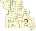
This is a locator map showing Iron County in Missouri. For more information, see Commons:United States county locator maps.
(c) Anela aus der englischsprachigen Wikipedia, CC BY-SA 3.0
One side of Fort Davidson as seen today. At far right, one can see the crater from the blast blowing up the powder magazine. Photo by Valerie Holifield. https://www.flickr.com/photos/anela/260420264/
Autor/Urheber: Skye Marthaler, Lizenz: CC BY-SA 3.0
Ursuline Academy-Arcadia College Historic District, located in Arcadia, w:Iron County, Missouri. Listed 1 July 1998. National Register of Historic Places


