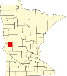
Liste der Einträge im National Register of Historic Places im Grant County (Minnesota)
Die Liste der Einträge im National Register of Historic Places im Grant County in Minnesota führt alle Bauwerke und historischen Stätten im Grant County auf, die in das National Register of Historic Places aufgenommen wurden.[1]
Aktuelle Einträge
| [2] | Name[3] | Bild | Eintragsdatum | Lage | Ort | Beschreibung |
|---|---|---|---|---|---|---|
| 1 | Fort Pomme de Terre Site | 1974 ID-Nr. 74001018 | County Road 4 46° 4′ 0,6″ N, 95° 52′ 56,5″ W | Pelican Lake Township | Stelle, an der 1859 eine Postkutschenstation errichtet worden war; von der US-Army nach dem Sioux-Aufstand von 1862 befestigt[4] | |
| 2 | Grant County Courthouse | 1985 ID-Nr. 85001945 | 10 2nd Street, Northeast 45° 59′ 41,4″ N, 95° 58′ 36,5″ W | Elbow Lake | 1905 errichtetes Gerichts- und Verwaltungsgebäude | |
| 3 | Roosevelt Hall | 1985 ID-Nr. 85001819 | Hawkins Avenue 45° 54′ 39,4″ N, 95° 53′ 18,6″ W | Barrett | 1934 von der Civil Works Administration errichtete Versammlungshalle |
Frühere Einträge
| [2] | Name[3] | Bild | Eintragsdatum | Lage | Ort | Beschreibung |
|---|---|---|---|---|---|---|
| 1 | Minneapolis, St. Paul and Sault Ste. Marie Depot | 1988 ID-Nr. 88002152 | 111 Central Avenue 45° 59′ 21,9″ N, 95° 58′ 44,8″ W | Elbow Lake |
Siehe auch
Weblinks
Einzelnachweise
- ↑ Auszug aus dem National Register of Historic Places - Grant County Abgerufen am 23. April 2013
- ↑ a b Die Nummerierung in dieser Listenspalte ist an der vom National Park Service vorgelegten Reihenfolge der Einträge orientiert; die Farben unterscheiden verschiedene Schutzgebietstypen des National Park Systems mit landesweiter Bedeutung (z. B. National Historic Landmarks) von den sonstigen Einträgen im National Register of Historic Places.
- ↑ a b National Register Information System. In: National Register of Historic Places. National Park Service. Abgerufen am 9. Juli 2010.
- ↑ William M. Goetzinger Pomme de Terre: A Frontier Outpost in Grant County (PDF; 2,8 MB) Abgerufen am 23. April 2013
Auf dieser Seite verwendete Medien
New design for the Flag of Minnesota, adopted on May 11, 2024.
This is a locator map showing Grant County in Minnesota. For more information, see Commons:United States county locator maps.
Autor/Urheber: Gobonobo, Lizenz: CC BY-SA 3.0
Grant County Courthouse
Autor/Urheber: Gobonobo, Lizenz: CC BY-SA 3.0
Roosevelt Hall in Barrett, Minnesota
Autor/Urheber: Gobonobo, Lizenz: CC BY-SA 3.0
Site of Fort Pomme de Terre with a stone marker bearing a plaque that reads "In memory of Corporal Zenas Blackman age 31 and Private H. Adam Hare age 34 Co. D 8th. Minnesota Regiment garrisoned at Pomme de Terre Stockade Killed May 2, 1863 by indians and buried here, near the stockade. This tablet erected by the Carl A. Hanson Post, Inc. American Legion, Elbow Lake, Minn. 1933"


