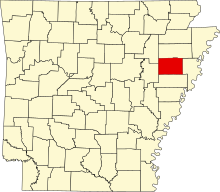
Liste der Einträge im National Register of Historic Places im Cross County
Die Liste der Einträge im National Register of Historic Places im Cross County in Arkansas führt die Bauwerke und historischen Stätten im Cross County auf, die in das National Register of Historic Places aufgenommen wurden.[1]
Legende
| NRHP | Historic Place |
|---|---|
| HD | Historic District |
| NHL | National Historic Landmark |
Aktuelle Einträge
| [2] | Name[3] | Bild | Eintragsdatum | Lage | Ort | Beschreibung |
|---|---|---|---|---|---|---|
| 1 | Isaac Block House | 1998 ID-Nr. 98000851 | 404 East Hamilton Street 35° 13′ 35″ N, 90° 47′ 19″ W | Wynne | ||
| 2 | Capt. Isaac N. Deadrick House | 1993 ID-Nr. 93000964 | Nordwestlich der Kreuzung von US 64 und AR 163 35° 15′ 2″ N, 90° 42′ 44″ W | Levesque | ||
| 3 | East Hamilton Avenue Historic District | 2011 ID-Nr. 11000330 | East Hamilton Avenue zwischen North Falls Boulevard und North Killough Road 35° 13′ 31″ N, 90° 48′ 51″ W | Wynne | ||
| 4 | Giboney-Robertson-Stewart House | 1998 ID-Nr. 98000585 | 734 Hamilton Avenue 35° 13′ 32″ N, 90° 47′ 5″ W | Wynne | ||
| 5 | Grace Episcopal Church | 1992 ID-Nr. 92000106 | 614 East Poplar Street 35° 13′ 40″ N, 90° 47′ 12″ W | Wynne | ||
| 6 | John H. Johnston Cotton Gin Historic District | 2005 ID-Nr. 05000490 | Kreuzung von US 64 und AR 163 35° 15′ 1″ N, 90° 42′ 48″ W | Levesque | ||
| 7 | Memphis to Little Rock Road-Strong’s Ferry Segment | 2012 ID-Nr. 12000274 | Adresse nicht veröffentlicht | westlich von Jennette | Teil des Trail of Tears der Cherokee (Multiple Property Submission) | |
| 0 | Memphis to Little Rock Road-Village Creek Segment | 2003 ID-Nr. 03000193 | Östlich des Lake Austell im Village Creek State Park 35° 8′ 48″ N, 90° 43′ 0″ W | Südöstlich von Wynne | Teil des Trail of Tears | |
| 9 | New Hope School | 2008 ID-Nr. 08001037 | 3762 AR 284 35° 12′ 25,7″ N, 90° 43′ 55,7″ W | Wynne | ||
| 10 | Parkin Indian Mound | (c) Heironymous Rowe in der Wikipedia auf Englisch, CC BY-SA 3.0 | 1966 ID-Nr. 66000200 | Kreuzung von US 64 und AR 184 35° 16′ 37,7″ N, 90° 33′ 26,7″ W | Parkin | |
| 11 | South Elementary School | 2006 ID-Nr. 06000419 | 711 East Union Avenue 35° 13′ 31″ N, 90° 47′ 9″ W | Wynne | ||
| 12 | Wittsburg Fortification | 2002 ID-Nr. 02001626 | Adresse nicht veröffentlicht | Wittsburg | ||
| 13 | Wittsburg Store and Gas Station | 2000 ID-Nr. 00001386 | County Road 739 35° 13′ 5″ N, 90° 42′ 0″ W | Wittsburg | ||
| 14 | Woman’s Progressive Club | 1990 ID-Nr. 90000430 | Rowena Street Ecke Merriman Avenue 35° 13′ 25″ N, 90° 47′ 21″ W | Wynne | ||
| 15 | Wynne Commercial Historic District | 2009 ID-Nr. 09001115 | Abgegrenzt durch Front Street, Commercial Avenue, Terry Street, Wilson Street und Pecan Avenue 35° 13′ 23,4″ N, 90° 47′ 30,2″ W | Wynne | ||
| 16 | Wynne Post Office | 1998 ID-Nr. 98000914 | 402 East Merriman Avenue 35° 13′ 27″ N, 90° 47′ 21″ W | Wynne | ||
| 17 | Wynne Wholesale Commercial Historic District | 2010 ID-Nr. 09000772 | West Merriman Street und Martin Luther King Drive 35° 13′ 28,3″ N, 90° 47′ 38,1″ W | Wynne |
Frühere Einträge
| [2] | Name[3] | Bild | Eintragsdatum | Lage | Ort | Beschreibung |
|---|---|---|---|---|---|---|
| 1 | Missouri-Pacific Depot | 1999 ID-Nr. 92000623 | North Front Street Ecke East Hamilton Avenue 35° 13′ 9,2″ N, 90° 47′ 36,5″ W | Wynne |
Siehe auch
Einzelnachweise
- ↑ Auszug aus dem National Register of Historic Places – Cross County Abgerufen am 28. September 2012
- ↑ a b Die Nummerierung in dieser Listenspalte ist an der vom National Park Service vorgelegten Reihenfolge der Einträge orientiert; die Farben unterscheiden verschiedene Schutzgebietstypen des National Park Systems mit landesweiter Bedeutung (z. B. National Historic Landmarks) von den sonstigen Einträgen im National Register of Historic Places.
- ↑ a b National Register Information System. In: National Register of Historic Places. National Park Service. Abgerufen am 24. April 2008.
Auf dieser Seite verwendete Medien
Autor/Urheber: Thomas R Machnitzki (thomas@machnitzki.com), Lizenz: CC BY 3.0
Wynne, Arkansas.
(c) Heironymous Rowe in der Wikipedia auf Englisch, CC BY-SA 3.0
A photo of the main mound and the moat at the Parkin Archeological State Park.
Autor/Urheber: Thomas R Machnitzki (thomas@machnitzki.com), Lizenz: CC BY 3.0
Wynne, Arkansas. Post office.
Post officeAutor/Urheber: Thomas R Machnitzki (thomas@machnitzki.com), Lizenz: CC BY 3.0
East Hamilton Ave. Historic District in Wynne, Arkansas.
Autor/Urheber: Thomas R Machnitzki (thomas@machnitzki.com), Lizenz: CC BY 3.0
Wynne Commercial Historic District in Wynne, Arkansas.
Autor/Urheber: Thomas R Machnitzki, Lizenz: CC BY 3.0
Trail of Tears — intact portion concurring with the Old Military Road.
- In Village Creek State Park, south of Wynne, Arkansas.
Autor/Urheber: Thomas R Machnitzki (thomas@machnitzki.com), Lizenz: CC BY 3.0
Levesque, Arkansas.
This is a locator map showing Cross County in Arkansas. For more information, see Commons:United States county locator maps.


