Liste der Einträge im National Register of Historic Places im Calhoun County (Illinois)
Die Liste der Einträge im National Register of Historic Places im Calhoun County in Illinois führt alle sechs Bauwerke und historischen Stätten im Calhoun County auf, die in das National Register of Historic Places aufgenommen wurden.[1]
Legende
| NRHP | Historic Place |
|---|---|
| HD | Historic District |
Aktuelle Einträge
| [2] | Name[3] | Bild | Eintragsdatum | Lage | Ort | Beschreibung |
|---|---|---|---|---|---|---|
| 1 | Brussels Historic District | 1998 ID-Nr. 98000981 | Entlang der Main Street und der Community Street 38° 56′ 59″ N, 90° 35′ 13″ W | Brussels | ||
| 2 | Golden Eagle-Toppmeyer Site | 1979 ID-Nr. 79000816 | Adresse nicht veröffentlicht | Brussels | ||
| 3 | Kamp Mound Site | 1978 ID-Nr. 78001114 | Adresse nicht veröffentlicht | Kampsville | ||
| 4 | Kamp Store | 1994 ID-Nr. 94000027 | Oak Street Ecke Broadway 39° 17′ 54″ N, 90° 36′ 37″ W | Kampsville | ||
| 5 | Michael Klunk Farmstead | 1982 ID-Nr. 82002518 | Adresse nicht veröffentlicht | Michael | ||
| 6 | Schudel No. 2 Site | 1979 ID-Nr. 79000817 | Adresse nicht veröffentlicht | Hamburg |
Siehe auch
Weblinks
Einzelnachweise
- ↑ Auszug aus dem National Register of Historic Places – Calhoun County Abgerufen am 17. November 2012.
Suchmaske Datenbank im National Register Information System, National Park Service. - ↑ Die Nummerierung in dieser Listenspalte ist an der vom National Park Service vorgelegten Reihenfolge der Einträge orientiert; die Farben unterscheiden verschiedene Schutzgebietstypen des National Park Systems mit landesweiter Bedeutung (z. B. National Historic Landmarks) von den sonstigen Einträgen im National Register of Historic Places.
- ↑ National Register Information System. In: National Register of Historic Places. National Park Service. Abgerufen am 9. Juli 2010.
Auf dieser Seite verwendete Medien
Fields on the western side of Illinois Route 100 north of Kampsville in Carlin Precinct, Calhoun County, Illinois, United States. These fields are part of the village associated with the Kamp Mound Site; as an important archaeological site, it is listed on the National Register of Historic Places.
Fields at the Toppmeyer Site, located on the western side of Quarry Road southeast of Brussels in Point Precinct, Calhoun County, Illinois, United States. As an important archaeological site, it is listed on the National Register of Historic Places along with the adjacent Golden Eagle earthwork site.
Looking eastward at buildings on the Michael Klunk Farmstead, located along Crater Creek Road south of Kampsville, Illinois, United States. The farmstead is listed on the National Register of Historic Places.
Overview of the Schudel No. 2 Site, located on the western side of Mississippi River Road west of Hardin in Gilead Precinct, Calhoun County, Illinois, United States. As an important archaeological site, it is listed on the National Register of Historic Places.
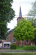
Front and eastern side of St. Mary's Catholic Church, located at 115 E. Main Street in Brussels, Illinois, United States. Built in 1902, it is part of the Brussels Historic District, a historic district that is listed on the National Register of Historic Places.
Front and southern side of the Kamp Store, located on the northeastern corner of the junction of Broadway (Illinois Route 100) and Oak Street in Kampsville, Illinois, United States. Built in 1902, it is listed on the National Register of Historic Places.
This is a locator map showing Calhoun County in Illinois. For more information, see Commons:United States county locator maps.


