Liste der Countys in Connecticut
Der US-Bundesstaat Connecticut ist in acht Countys unterteilt. Die County Seats haben in Connecticut seit 1960 eine untergeordnete Rolle, denn es gibt keine County-Regierung mehr. Der FIPS-Code für Connecticut ist 09.
| County | FIPS Code [1] | County Seat (kein Verwaltungssitz mehr)[2] | Gegründet [2] | Ursprung | Namensherkunft [3] | Bevölkerung [4] | Fläche [2] | Karte |
|---|---|---|---|---|---|---|---|---|
| Fairfield County | 001 | Fairfield (1666–1853) Bridgeport (1853–1960) | 1666 | Eines der vier ursprünglich errichteten Countys | An den Ufern gibt es große Salzfelder | 916.829 | 1.621 km² (626 sq mi) |  |
| Hartford County | 003 | Hartford (1666–1960) | 1666 | Eines der vier ursprünglich errichteten Countys | Nach Hertfordshire in England | 894.014 | 1.906 km² (736 sq mi) |  |
| Litchfield County | 005 | Litchfield (1751–1960) | 1751 | Aus Teilen von Fairfield County, Hartford County, und New Haven County | Lichfield in England | 189.927 | 2.383 km² (920 sq mi) |  |
| Middlesex County | 007 | Middletown (1785–1960) | 1785 | Aus Teilen von Hartford County und New London County | Middlesex in England | 165.676 | 956 km² (369 sq mi) |  |
| New Haven County | 009 | New Haven (1666–1960) | 1666 | Eines der vier ursprünglich errichteten Countys | Nach New Haven Colony, das als Hafen für Puritaner gebaut wurde. Dort wurden sie nicht verfolgt. | 862.477 | 1.570 km² (606 sq mi) |  |
| New London County | 011 | New London (1666–1960) | 1666 | Eines der vier ursprünglich errichteten Countys | London | 274.055 | 1.725 km² (666 sq mi) |  |
| Tolland County | 013 | Tolland (1785–1889) Rockville (1889–1960) | 1785 | Aus Teilen von Hartford County und Windham County | Hamlet von Tolland, Somerset, England | 152.691 | 1.062 km² (410 sq mi) |  |
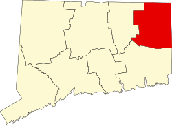
| Windham County | 015 | Windham (1726–1819) Brooklyn (1819–1895) Willimantic and Putnam (1895–1960) | 1726 | Aus Teilen von Hartford County, und New London County | Nach Windham (jetzt Wineham) in Sussex, England | 118.428 | 1.329 km² (513 sq mi) |  |
Ehemalige Countys
- Trumbull County – Connecticut Western Reserve, fiel 1800 an Ohio.
- Westmoreland County – ein Gebiet bei Wilkes-Barre, fiel 1784 an Pennsylvania.
Einzelnachweise
- ↑ EPA County FIPS Code Listing. In: EPA.gov. Abgerufen am 23. Februar 2008.
- ↑ a b c National Association of Counties: NACo - Find a county. Archiviert vom Original am 10. April 2005. Abgerufen am 30. April 2008.
- ↑ Beatty, Michael: County Name Origins of the United States. McFarland Press, 2001, ISBN 0-7864-1025-6.
- ↑ Durch das Missouri Census Data Center ausgewertete Daten der Volkszählung (Seite nicht mehr abrufbar, Suche in Webarchiven) Info: Der Link wurde automatisch als defekt markiert. Bitte prüfe den Link gemäß Anleitung und entferne dann diesen Hinweis. , abgerufen am 4. Oktober 2012
Auf dieser Seite verwendete Medien
This is a locator map showing Windham County in Connecticut. For more information, see Commons:United States county locator maps.
This is a locator map showing Tolland County in Connecticut. For more information, see Commons:United States county locator maps.
This is a locator map showing Fairfield County in Connecticut. For more information, see Commons:United States county locator maps.
This is a locator map showing New London County in Connecticut. For more information, see Commons:United States county locator maps.
The image was downloaded from en.wiki (en:Image:Connecticut-counties-map.gif) under the {{PD-USGov}} license tag. Wars 05:30, 12 September 2006 (UTC)
This is a locator map showing Litchfield County in Connecticut. For more information, see Commons:United States county locator maps.
This is a locator map showing Hartford County in Connecticut. For more information, see Commons:United States county locator maps.
This is a locator map showing Middlesex County in Connecticut. For more information, see Commons:United States county locator maps.
This is a locator map showing New Haven County in Connecticut. For more information, see Commons:United States county locator maps.


