Leonardville
| Dorf Leonardville Naosanabis (historisch) | |||
|---|---|---|---|
| |||
 | |||
| Motto | The Best (Das Beste) | ||
| Basisdaten | |||
| Einwohnerzahl Fläche Einwohnerdichte | 2.099 (Zählung 2023)[1] 56,75 km² 37 Einw./km² | ||
| Staat Region Wahlkreis | Namibia Omaheke Aminuis | ||
| Gründungsdatum | |||
| Kfz-Kennzeichen Telefonvorwahl | |||
| Website | |||
(c) Karte: NordNordWest, Lizenz: Creative Commons by-sa-3.0 de | |||
| Politische Daten | |||
| Bürgermeister/in | ? (SWAPO) | ||
| Letzte Wahl | 2020 | ||
| Geographische Daten | |||
| Koordinaten | 23° 30′ S, 18° 48′ O | ||
Leonardville ist ein Dorf im Wahlkreis Aminuis in der Region Omaheke in Zentralost-Namibia. Es hat 2099 Einwohner (Stand 2023) auf einer Fläche von 56,7501 km².[1]
Leonardville ist der historische Hauptort der Lambert-Orlam, einem Clan der Orlam-Nama.
Kommunalpolitik
Bei den Kommunalwahlen 2020 wurde folgendes amtliche Endergebnis ermittelt (Trend zu den Kommunalwahlen 2015 angegeben).[2]
| Partei | Stimmen | Stimmenanteil | Sitze |
|---|---|---|---|
| SWAPO | 336 | 57,2 % | 3 |
| LPM NEU | 151 | 25,7 % | 1 |
| NUDO | 60 | 10,2 % | 1 |
| PDM | 40 | 6,8 % | 0 |
| Insgesamt | 587 | 100 % | 5 |

Weblinks
Einzelnachweise
- ↑ a b Omaheke Region. Namibia Statistics Agency, 2023 Census. Abgerufen am 18. Juni 2024.
- ↑ Government Gazette, Republic of Namibia, 1. April 2021, Nr. 7494, S. 14.
Auf dieser Seite verwendete Medien
(c) Uwe Dedering in der Wikipedia auf Deutsch, CC BY-SA 3.0
Location map of Namibia
Equirectangular projection. Strechted by 108.0%. Geographic limits of the map:
- N: -16.4° N
- S: -29.6° N
- W: 11.0° E
- E: 25.8° E
(c) Karte: NordNordWest, Lizenz: Creative Commons by-sa-3.0 de
Wahlkreis Aminuis in der Region Omaheke, Namibia (2014)
Autor/Urheber:
Leonardville Village Council
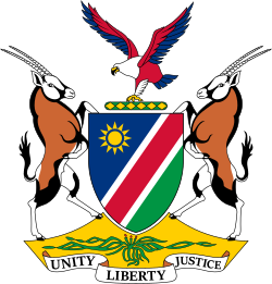
, Lizenz: PD-Amtliches WerkWappen von Leonardville
Autor/Urheber: Hp.Baumeler, Lizenz: CC BY-SA 4.0
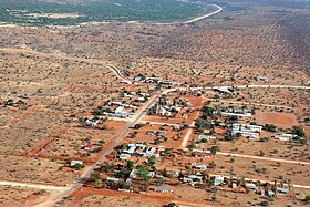
Vogelperspektive von Leonardville (Bild vom Oktober 2015)


