Le Bez
| Le Bez Lo Bèç | ||
|---|---|---|
 |
| |
| Staat | Frankreich | |
| Region | Okzitanien | |
| Département (Nr.) | Tarn (81) | |
| Arrondissement | Castres | |
| Kanton | Les Hautes Terres d’Oc | |
| Gemeindeverband | Sidobre Vals et Plateaux | |
| Koordinaten | 43° 37′ N, 2° 29′ O | |
| Höhe | 353–813 m | |
| Fläche | 32,13 km² | |
| Einwohner | 821 (1. Januar 2019) | |
| Bevölkerungsdichte | 26 Einw./km² | |
| Postleitzahl | 81260 | |
| INSEE-Code | 81031 | |
| Website | https://www.le-bez.fr/ | |
Le Bez (occitanisch: Lo Bèç) ist eine südfranzösische Gemeinde mit 821 Einwohnern (Stand: 1. Januar 2019) im Département Tarn in der Region Okzitanien (vor 2016: Midi-Pyrénées). Le Bez gehört zum Arrondissement Castres und zum Kanton Les Hautes Terres d’Oc (bis 2015: Kanton Brassac).
Lage
Le Bez liegt zwischen den Flüssen Agout und Durenque im Regionalen Naturparks Haut-Languedoc, etwa 18 Kilometer in ostnordöstlicher Richtung von Castres entfernt. Umgeben wird Le Bez von den Nachbargemeinden Vabre und Fontrieu im Norden, Brassac im Osten, Lasfaillades im Südosten, Cambounès im Süden, Saint-Salvy-de-la-Balme und Burlats im Westen sowie Lacrouzette im Nordwesten.
Bevölkerungsentwicklung
| Jahr | 1962 | 1968 | 1975 | 1982 | 1990 | 1999 | 2006 | 2013 |
| Einwohner | 643 | 602 | 606 | 612 | 654 | 716 | 786 | 842 |
| Quelle: Cassini und INSEE | ||||||||
Sehenswürdigkeiten
- Kirche
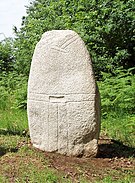
- Statuenmenhir du Baissas, Statuenmenhir de la Monjarié und Statuenmenhir de Guior-Haut
Weblinks
Auf dieser Seite verwendete Medien
(c) Karte: NordNordWest, Lizenz: Creative Commons by-sa-3.0 de
Positionskarte von Frankreich mit Regionen und Départements
Autor/Urheber: Sidoubret, Lizenz: CC BY-SA 4.0
This menhir statue belongs to the family of menhirs of the "Saint-ponien" (high Languedoc, Tarn / Hérault) civilization dated Neolithic. It measures 2.70m and has the characteristic symbols: harness, dagger, belt and buckle, legs. Made of granite (local stone). He was beheaded in an old age.


