Laubeuf-Fjord
| Laubeuf-Fjord | ||
|---|---|---|
 | ||
| Verbindet Gewässer | Marguerite Bay | |
| mit Gewässer | The Gullet | |
| Trennt Landmasse | Adelaide-Insel | |
| von Landmasse | Arrowsmith-Halbinsel, Grahamland | |
| Daten | ||
| Geographische Lage | 67° 20′ S, 67° 50′ W | |
| ||
| Länge | 40 km | |
| Geringste Breite | 10 km | |
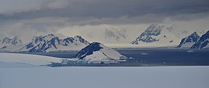
Der Laubeauf-Fjord (französisch Fiord Laubeuf) ist ein 40 km langer und durchschnittlich 10 km breiter Sund mit nordsüdlicher Ausrichtung vor der Westküste des Grahamlands im Norden der Antarktischen Halbinsel. Er liegt zwischen dem östlich-zentralen Teil der Adelaide-Insel und dem südlichen Abschnitt der Arrowsmith-Halbinsel und stellt die Verbindung zwischen der Marguerite Bay im Süden und der nördlich liegenden Meerenge The Gullet her.
Dort liegt auch der Quilp Rock.
Entdeckt wurde der Fjord bei der Fünften Französischen Antarktisexpedition (1908–1910) unter der Leitung des Polarforschers Jean-Baptiste Charcot. Dieser benannte ihn nach dem französischen Schiffbauingenieur Maxime Laubeuf (1864–1939), der die Arbeiten beim Bau der Antriebsmaschine für Charcots Forschungsschiff Pourquoi Pas ? beaufsichtigte.
Weblinks
- Laubeauf Fjord. In: Geographic Names Information System. United States Geological Survey, United States Department of the Interior, archiviert vom (englisch).
- Laubeauf Fjord auf geographic.org (englisch)
(c) Karte: NordNordWest, Lizenz: Creative Commons by-sa-3.0 de
| |||
Meerengen entlang der Küste des Grahamlandes |
Auf dieser Seite verwendete Medien
(c) Karte: NordNordWest, Lizenz: Creative Commons by-sa-3.0 de
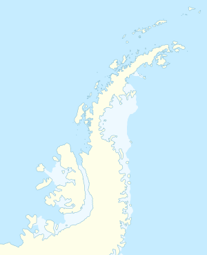
Positionskarte der Antarktischen Halbinsel
Autor/Urheber: Vincent van Zeijst, Lizenz: CC BY-SA 3.0
Laubeuf Fjord in the Antarctic Peninsula region, seen from a position high on the Wormald Ice Piedmont on Adelaide Island. Viewing direction is toward the NE. In the centre, behind some of the ice cliffs of the piedmont, is Webb Island. Left of Webb Island and further away is Wyatt Island. All the mountains in the background are on the Arrowsmith Peninsula, which is part of the Loubet Coast of the Antarctic Peninsula. The dark mountains at the right edge are the northernmost peaks of the Haslam Heights. The long front of coastal ice cliffs left of these peaks are the mouths of the Vallot Glacier and Ward Glacier. The large mountain behind this ice front is Pryor Peak; it is more than 1000 m high and is part of the Tyndall Mountains.


