Lake-Eyre-Nationalpark
| Lake Eyre National Park | ||
|---|---|---|
| Salzkruste | ||
| Lage: | South Australia, Australien | |
| Besonderheit: | Salzpfanne | |
| Nächste Stadt: | Marree | |
| Fläche: | 13.492,51 km² | |
| Gründung: | 1985 | |
| Satellitenfoto | ||
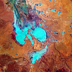
Der Lake-Eyre-Nationalpark, der eine Fläche von 12.880 km² umfasst, liegt in South Australia am östlichen Ufer des Salzsees Lake Eyre, ungefähr 750 Kilometer nördlich von Adelaide und 60 Kilometer östlich von William Creek. Der Park umfasst den nördlichen Salzsee (Lake Eyre North), den südlichen, kleineren Salzsee (Lake Eyre South), sowie Teile der Tirariwüste.[1]
Dieser Park liegt in einer der trockensten Gegenden Australiens. Wird der See in Gänze durch Zuflüsse mit Wasser gefüllt, und dies war letztmals im Jahre 2000 der Fall, bewohnen ihn vor allem Pelikane, Möwen und Enten. Sie ernähren sich von Fischen und kleinen Krebsen, die die Flüsse in den See spülen. Im Park gibt es Reptilien wie den Lake Eyre Dragon und es wachsen Queller, Salt- und Bluebush und kleinwüchsige Akazien. Da der See im Durchschnitt nur alle 25 Jahre mit Wasser gefüllt ist, weist er meistens eine etwa bis zu 46 cm dicke Salzkruste auf.
Von William Creek, Marree oder Coober Pedy aus können Rundflüge über den Park gechartert werden. Für eine Fahrt in den Park benötigt man allradangetriebene Fahrzeuge und einen South Australian Desert Park Pass, mit einem normalen PKW kann nur bis Oodnadatta gefahren werden. Außerhalb des Parks kann bei Muloorina Station kampiert werden. Im Park ist nur die Nutzung von Gaskochern erlaubt und kein offenes Feuer. Die beste Reisezeit ist April bis Oktober.
Weblinks
Einzelnachweise
- ↑ Steve Parish: Australian Touring Atlas. Steve Parish Publishing Pty. Ltd. Archerfield QLD (2007). ISBN 978-1-74193-232-4. S. 72+73
Auf dieser Seite verwendete Medien
A false colour picture. The purpose of NASA's Earth Observatory is to provide a freely-accessible publication on the Internet where the public can obtain new satellite imagery and scientific information about our home planet. The focus is on Earth's climate and environmental change. In particular, we hope our site is useful to public media and educators. Any and all materials published on the Earth Observatory are freely available for re-publication or re-use, except where copyright is indicated. We ask that NASA's Earth Observatory be given credit for its original materials.
Autor/Urheber: Tentotwo, Lizenz: CC BY-SA 3.0
Location map of South Australia, Australia
Equidistant cylindrical projection, latitude of true scale 31.27° S (equivalent to equirectangular projection with N/S stretching 117 %). Geographic limits of the map:
- N: 25.6° S
- S: 38.5° S
- W: 128.5° E
- E: 141.5° E


